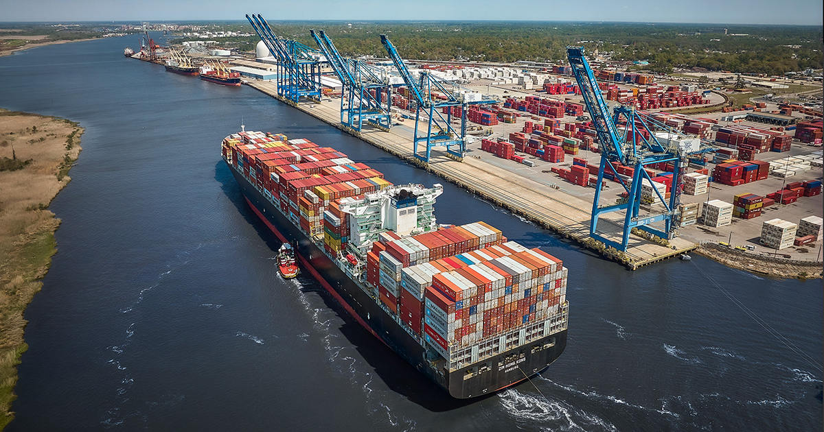
The U.S. Army Corps of Engineers is pushing forward its proposal to deepen the Wilmington Harbor by an additional 5 feet and widen segments of the shipping lane up the Cape Fear River.
The Corps-prepared final Wilmington Harbor 403 environmental impact statement, or EIS, sticks with a plan to extend the entrance of the federal navigation channel by about 9 miles, deepen the channel from 42 feet to 47 feet and widen portions of it from the river mouth about 28 miles to the Wilmington port. The construction, which is projected to begin in 2030 and take about six years to complete, is estimated to cost more than $1.3 billion.
Supporter Spotlight

The North Carolina State Ports Authority says the project is needed to accommodate larger, deep-draft container vessels at the Wilmington port in U.S. East Coast-Asia trade. Deepening the shipping channel would attract more import and export business and boost job growth in the state, ports officials say.
The Port of Wilmington is the 67th largest port in the nation when measured by total cargo tonnage. In 2022, about 7.6 million tons of cargo, including 6.6 million tons of largely containerized foreign cargo, and 1 million tons of domestic cargo was shipped through the Wilmington Harbor, according to the Corp’s Waterborne Commerce Statistics Center.
The final environmental impact statement and accompanying letter report, as required under Section 403 of the 2020 Water Resources Development Act, will be formally submitted this month to the Office of the Assistant Secretary of the Army for Civil Works for review and then a record of decision, or the final stage of the approval process, will be published in the Federal Register.
Once that office receives those documents, the North Carolina Department of Environmental Quality’s Division of Coastal Management may submit objections it raised earlier this year about the proposed project, one the division’s director wrote would have “significant adverse impacts to coastal resources.”
Looking back: Port plan would have ‘significant adverse impacts’
Supporter Spotlight

“The FEIS acknowledges the State’s federal consistency objection but does not resolve it,” a Division of Coastal Management spokesperson said in an email responding to a request for comment. “DCM and DEQ will continue to come to the table with the Army Corps and the State Ports to discuss a potential path forward.”
Wilmington District Public Affairs Specialist Jed Cayton explained in an email to Coastal Review last month that federal rules outline how a state agency must reply when that agency objects to a federal agency’s consistency choice.
“The regulation provides several potential paths forward, including not proceeding with the action, attempting to resolve differences with the state, or determining that the federal action is consistent to the maximum extent practicable with the state’s coastal zone management program,” Cayton wrote. “The Wilmington District is consulting with its higher headquarters to determine the specific course of action regarding the State’s non-concurrence with the USACE’s coastal consistency determination.”
The Corps anticipates that the record of decision will be issued in October.
Division officials argue that the Corps’ draft EIS failed to adequately assess cumulative flooding impacts or thoroughly detail areas where dredged material would be placed, did not sufficiently account for potential effects on fisheries habitat, freshwater wetlands, shorelines, or state, historic and other sites along the Cape Fear River, and did not evaluate PFAS in the lower Cape Fear River sediment.
Residents, environmental organizations and local governments have widely expressed similar concerns, saying that the project will threaten historic and cultural resources along the river, accelerate erosion and exacerbate flooding, destroy habitat, is not economically justified, and will disperse contaminants in the riverbed’s sediment into marshes and onto public beaches.
“The Final Letter Report and FEIS continue to show that this project is unnecessary and extraordinarily damaging to the environment,” Southern Environmental Law Center attorneys wrote in a July 31 letter in response to those documents. “The costs of this harbor expansion continue to climb as the alleged need and purported benefits simultaneously dwindle. On top of the questionable economic considerations, the project would come with a host of permanent harms to the natural environment of the Lower Cape Fear, cherished by locals and tourists alike.”
The letter, written on behalf of more than a half-dozen environmental and nonprofit organizations, including the North Carolina Coastal Federation, which publishes Coastal Review, concludes, “Before the Corps finalizes the record of decision, we implore the Corps to reevaluate the economic justifications for this project, complete all required consultations, and address the significant questions regarding the project’s environmental impacts.”
Looming questions, PFAS concerns
The Corps has identified several areas in which it would place material dredged from the channel, including on nearby beaches in Brunswick and New Hanover counties and bird islands in the river. Dredged material would also be used for intertidal marsh restoration, fish habitat enhancement structures, riverbank protection, and back-bay marsh restoration.
About half of the construction dredge material would be placed for beneficial use instead of within federal offshore sites, according to the final EIS.
But worries persist over whether that material is contaminated by per- and polyfluoroalkyl substances, or PFAS, that have been discharged into the Cape Fear River for decades by upstream industries.
“Known contamination exists upstream, but it is not known if the sediment proposed to be dredged is contaminated,” the final EIS states. “At the time this EIS was prepared, this concern and the associated controversy remain, and the lack of resolution is hindering resolution of other issues that require state agency approvals and certifications.”
There are no federal or state human health limits for PFAS in sediment.
“The proposed project is not expected to contribute to PFAS contamination or impact drinking water contaminant concentrations. The sediment will be tested in accordance with all applicable requirements, including any new standards that are developed, prior to construction, and the results will be used to guide decisions related to use and disposal options based on the testing results and applicable criteria.”
A peer-reviewed study published by the Royal Science of Chemistry in 2022 confirms the presence of PFAS in the sediment in areas of the Cape Fear River.
The study targeted six PFAS, including legacy chemical compounds PFOA and PFOS, which have been phased out of production and replaced by what are referred to as emerging compounds. For this study, scientists focused on emerging compounds HFPO-DA, commonly referred to as GenX, PFMOAA, PFMOBA and PFMOPrA.
After collecting sediment samples between September 2017 and October 2019, scientists found that the highest concentration of PFAS was found in the sediment at Lock and Dam No. 1, some 39 miles upstream of Wilmington.
The overall trend of the data researchers collected found that PFAS in the Cape Fear River’s sediment “is decreasing as you go down the river,” said University of North Carolina Wilmington Professor Dr. Ralph Mead, program director of the NC PFAS Research Network and one of the study’s corresponding authors.
“There’s PFAS in the sediment, and while the concentration changes, of course, the distribution of PFAS compounds change as you move along the river itself,” Mead said in a recent telephone interview.
“One of the interesting things about the Cape Fear River is, as you move down the river, of course the salinity is going to increase. That salinity increase, depending on the freshwater flow, you can have salty water downtown by the hotels down on the riverfront,” he continued.
This leaves a question that does not yet have a clear answer. If a particle of sediment with PFAS in it floats down the river, will the salt make the particle hold on to PFAS or let it go?
“We all like to think that sediment is the ultimate sink for a lot of organic compounds, but sometimes, if the conditions and water chemistry is right, there can be a desorption that can take place,” Mead said.
He pointed out that researchers also detected a series of unknown fluorinated compounds in their sediment samples that were found by using high-resolution mass spectrometry, which can clearly distinguish tiny mass differences between molecules.
“The significance of this is we do not have standards for any of these compounds,” Mead said. “So, there’s potentially more PFAS present than we know of. I think this all ties back to the idea that there’s a lot of research that’s left to be done. There’s just a lot of questions out there and it’s not just the Cape Fear, there are other waterbodies as well that are impaired.”
Adverse impacts, outstanding issues
The final EIS identifies two “general types of meaningful adverse impacts,” including the destruction of fish habitat during construction and loss of freshwater, forested wetlands in the lower Cape Fear River.
The Corps would compensate for fish habitat loss by improving fish passages at lock and dams No. 1 and 2 more than 35 miles upstream of Wilmington “to enable anadromous fish to access quality habitat upstream of those facilities.”
The proposed plan to offset impacts to freshwater wetlands include preserving high-quality freshwater forested wetlands and upgrading lower-quality sites along the lower Cape Fear.
“Along with the adverse impacts, some beneficial effects would be expected,” according to the final EIS. “The deepened and widened channels would allow the cargo to be transported on a smaller number of larger and more modern and efficient vessels. In addition to the economic benefits, these transportation efficiencies would result in fewer vessel transits through the harbor yielding beneficial effects such as reduced fuel consumption, air emissions, vessel strikes to animals in the channels and shoreline erosion,” when compared to leaving the channel at its current depth.
The final EIS also notes that several controversial issues have been raised about the proposed project.
“Most were addressed and resolved,” the final EIS states.
But other controversial and outstanding issues remain, those “that require more time or additional action to resolve,” including federal review of the project’s impacts to endangered species and their habitat.
The Corps anticipates executing a programmatic agreement with agencies including the N.C. Department of Natural and Cultural Resources’ State Historic Preservation Office “this summer,” Cayton wrote. A programmatic agreement aims to address a project’s impacts on cultural and historic resources.
There are nearly 30 historic sites and properties within the proposed project’s area of potential effects, according to the State Historic Preservation Office.
Those sites include Dark Branch, a community in unincorporated Brunswick County where land remains largely owned by the descendants of previously enslaved residents, and Orton, a sprawling, former rice plantation.
Orton’s owner, billionaire hedge fund manager and conservation philanthropist Louis Moore Bacon, remains firmly opposed to the proposed harbor project, one he argues would threaten the expansive, historic rice field system and earthen dike in which he’s invested tens of millions of dollars to restore.
“The Cape Fear’s West Bank exists today because generations of conservationists, landowners, public agencies and local communities made the deliberate decision to protect one of North Carolina’s most important ecological and cultural landscapes,” Bacon said in an emailed statement to Coastal Review. “It would be a profound mistake to unravel that achievement with proposed Wilmington Harbor Dredging Project, which would threaten permanent harm to protected wetlands, wildlife habitat, historic rice fields built by the hands of enslaved African Americans and the historic Gullah Geechee cultural landscape. Before moving forward with what would be irreversible losses, we should be certain the project’s economic rationale still holds, and that every environmental and cultural consequence has been transparently and scientifically evaluated. Once these resources are compromised, nothing can fully bring them back.”