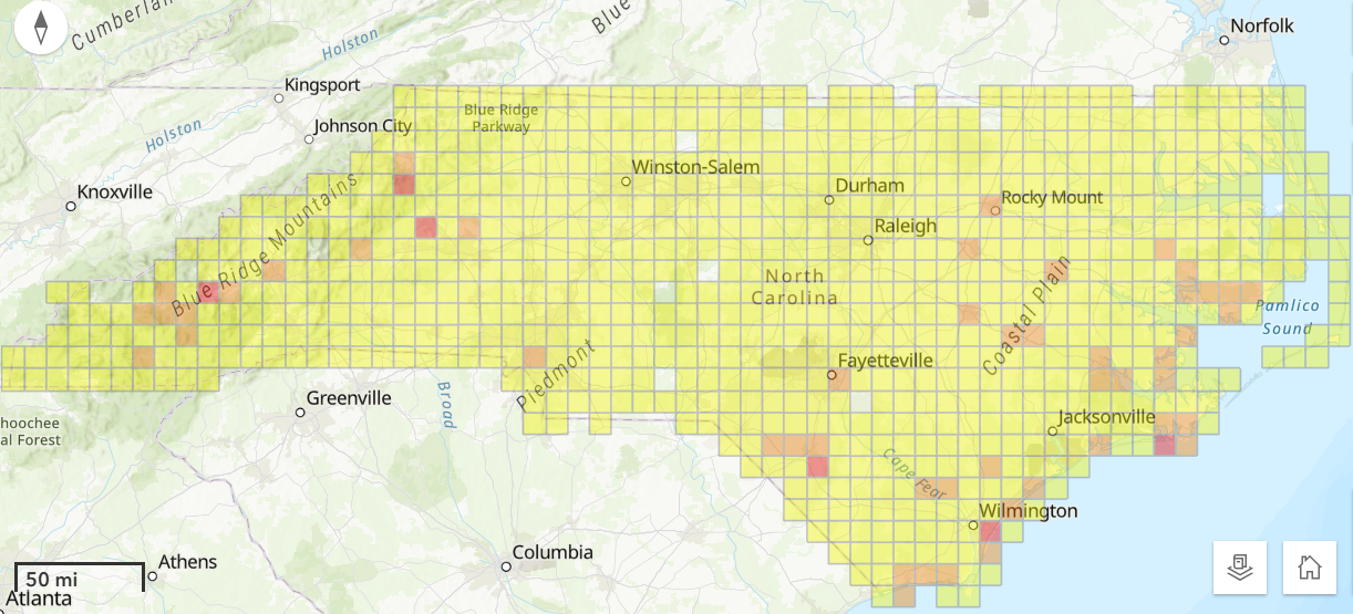
North Carolina’s Flood Resiliency Blueprint Tool now includes enhanced flood mapping and risk information for five river basins in Eastern North Carolina.
The online tool designed to help local governments, agencies and nongovernmental partners develop, evaluate and prioritize resilience actions has been updated with new nonregulatory or “advisory” flood maps for the Cape Fear, Lumber, Neuse, Tar-Pamlico, and White Oak river basins.
Supporter Spotlight
The need for new maps and modeling efforts were identified in the draft blueprint, which was created by the North Carolina Department of Environmental Quality at the direction of the General Assembly.
The updates were made through extensive coordination with local leaders, other state agencies, nongovernmental organizations, university researchers and evaluating programs in other states like Texas and Louisiana for guidance, according to an NCDEQ release.
NCDEQ Secretary Reid Wilson, in the release, stated that research from the University of North Carolina Chapel Hill found that more than 90,000 buildings in Eastern North Carolina flooded at least once from 1996 until 2020, and 43% of those buildings were outside the mapped Federal Emergency Management Agency floodplain. “The General Assembly’s investment in updated modeling and mapping means that North Carolinians in five river basins now have a more accurate picture of their actual flooding risk, Wilson said.”
The improved mapping was done in partnership with the North Carolina Floodplain Mapping Program, one overseen by the North Carolina Emergency Management.
“NC Emergency Management is proud to provide flood mapping support to DEQ which will produce additional flood mapping products to build resilient communities across the state,” N.C. Emergency Management Director Will Ray stated. “As part of a multi-year advisory flood data web application development project, which began in 2022, the NCEM Floodplain Management Program was able to provide data and resources to assist in this project, once again showing the whole-of-community approach to disaster preparedness In North Carolina.”
Supporter Spotlight

The mapping includes numerical models that simulate surface runoff and routing on a landscape, and are available for previously unmapped or undermapped basins too small to be included on regulatory maps and extend beyond what is normally included in traditional regulatory floodplain mapping.
The maps also include areas that flood despite being many miles from the nearest stream and allow communities to explore their future risk associated with projected growth patterns and the changing climate fueling more frequent and severe storms and sea level rise.
“These new maps, available through our Flood Resiliency Blueprint Tool, mean that Eastern North Carolinians can make more informed decisions and better investments to build their resilience in the face of more frequent and severe flooding,” Flood Resiliency Blueprint Manager Stuart Brown said in a release.
River Basin Action Strategies for the five river basins are expected to be available this summer, and new maps for the French Broad River Basin available this fall, according to DEQ.