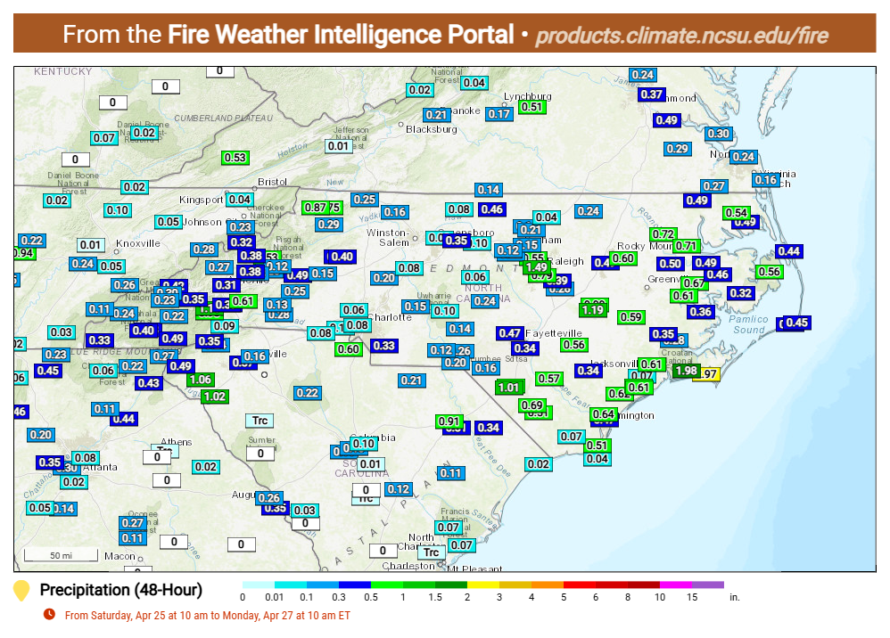
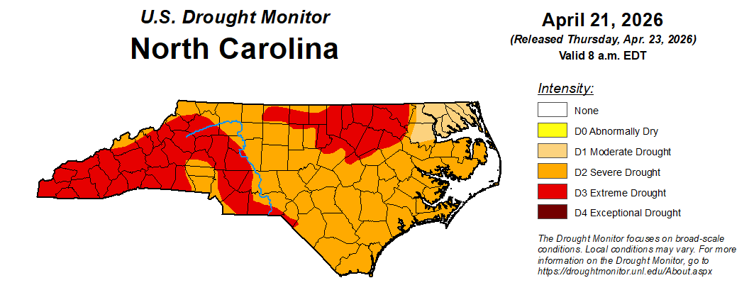
Though parts of North Carolina saw rainfall over the weekend, it didn’t touch the extreme drought conditions the state has been experiencing for at least six months.
State Climate Office of North Carolina Assistant State Climatologist Corey Davis told Coastal Review Monday that, while eastern North Carolina fared better than the rest of the state this weekend with the rainfall totals outperforming the forecasts — with A few spots like Lumberton and Goldsboro had around an inch, and parts of the Crystal Coast had 2 to 3 inches — “I don’t expect that will bring any improvements on the drought map this week.”
Supporter Spotlight
He is referring to the U.S. Drought Monitor’s weekly assessment of drought conditions. The North Carolina Drought Management Advisory Council, or DMAC, looks at data from Tuesday to Tuesday and submits its recommendations to the National Drought Mitigation Center. The center then publishes on that Thursday a map showing where conditions range from abnormally dry, or D1, to exceptional drought, or D4.
Often, Davis continued, the first rain event or two after a prolonged dry spell has little to no impact on things like soil moisture because the ground can hardened and then it becomes tough for water to infiltrate.
“Streamflow levels are also very low still, so it will take more rain to recharge those streams and their tributaries,” he said, calling the recent rain more of a “stop-the-bleeding kind of week.”
The state began moving toward these extreme drought conditions late last summer, the result of little rainfall overall, a quiet tropical storm season that did not contribute to the average precipitation numbers, and followed by a fairly dry fall and winter.
Since mid-March of this year, there has been a summer-like weather pattern with high pressure overhead, meaning unseasonably warm temperatures and little rainfall. That has helped drought intensify, and more than 40% of the state is now in extreme drought, which is considered the second most severe category in the U.S. Drought Monitor’s classification system, according to the climate office. Most of coastal North Carolina is in the severe drought category, the third category.
Supporter Spotlight

“The main hope is that this event is the start of a pattern change, and the forecast is promising for at least a couple more rain events through the end of the week,” Davis said Monday. “If we can pick up a few more inches of rain over the next week or two, then that could at least soften the edges of those Severe and Extreme Drought areas on the map and start bringing some gradual improvements.”
Davis made a similar point Thursday during a webinar “About Extreme Drought: What to know this spring and beyond.” He was joined by other members of DMAC, including its chair Klaus Albertin with the Division of Water Resources, N.C. Forest Service Forestry and Fire Environment Staff Forester Jamie Dunbar, and Senior Service Hydrologist Barrett Smith with the National Weather Service’s Raleigh office.
Davis said during the online presentation that the state had been experiencing a substantial drought for a while and will not be getting rid of the drought and its impacts with one event, or even in one month.
“Ideally, we would like to start seeing consistently at least 1 to 2 inches of rain per week,” Davis explained. “This time of the year, we tend to average between three-quarters of an inch to an inch of rain every week. We want at least to get that normal amount — an extra inch on top of that would be even better — and that would let us start chipping away at this drought and some of the ongoing impacts.”
In parts of northeastern North Carolina, “they are only, in quotes, in the moderate drought level, but that still means they are starting to see some crop stress and some low surface water levels,” Davis said.
The severe drought still prevalent across the coastal plain and central Piedmont means that it has been dry long enough that farmers are not going to see the yields that they expect if these conditions continue. And “at this point, that drought has been around long enough that it can start to take a toll on our water supplies.”
The final category, exceptional drought, “is reserved for the very rarest and the very driest events,” or “the most dire situation,” Davis said, which is “when water supplies are critically low, and you’ll see even more water restrictions implemented at even higher levels than what we’re seeing right now in extreme drought.”
Adding to the drought this winter was a La Niña pattern, which is where there tends to be cooler water out across the Pacific that weakens the jet stream, and ultimately shifting storms north, making it so places like the Great Lakes see more rain, while North Carolina usually experiences warmer and drier winter months.
The snowfall in late January and early February did not have much effect on the rain total deficits. “Even though we saw a foot of snow in some spots, that only amounted to about an inch of liquid, which is average per week at that time of the year,” he added.
Since the middle of March, there has been high pressure either just offshore or right over the Carolinas and has put the area in what Davis called a “heat dome” that is expected around June or July, not in April. “That’s why we’ve seen record high temperatures over the last few weeks and it has really blocked any sort of rai- making weather systems from moving through.”
Impacts that most people are starting to notice as the drought lingers is that the soil moisture is extremely low right now.
“What that tells us is that the soil moisture is not in any shape for planting right now. There is just no moisture there, especially in the upper layers of the soil. And even if we were to get some decent rainfall over the next week, that does not necessarily mean it is time to start planting,” he said, because anything that’s planted will establish a very shallow root system.
“And if this drought continues, or if we get into some hot weather this summer, those shallow roots will dry out very easily, and that can kill the plant,” he said.
Davis mentioned Community Collaborative Rain, Hail and Snow Network, or CoCoRaHs, a community science program that encourages people to make daily rainfall measurements and to submit condition monitoring reports that talk about the sort of dryness or impacts that they’re seeing around their home or in their neighborhood or in their community.
There was “a really interesting report from the northeastern part of the state,” Davis said about a submission from a farmer in Chowan County, which is in a moderate drought.
While farmers were able to get the corn in the fields, “the problem there is that a lot of those farmers will pull water directly from the Albemarle Sound, where it meets the Roanoke River, and use that to irrigate their farms,” Davis said. “Typically, in the upper levels of the sound there, you’re getting enough fresh water that’s being flushed down the river, then it’s not too much of a worry about saltiness.”
Because of the drought, water isn’t moving down the river, and salty water is pushing farther inland, which is too salty to use for irrigation. “That’s a very unique impact that we’ll see in that corner of the state during times of extreme drought like this one.”
Albertin with the Division of Water Resources explained that groundwater gives a good indication of the more extreme droughts.
“Surface water can fluctuate rapidly,” Albertin said. When there’s rainfall, groundwater is much more stable, but when there are low groundwater levels, widespread impacts to water resources across the state should be expected.
Another place drought presents itself is that the reservoirs are under more demand, and as the temperatures rise, evaporation is higher.
“When you have inflows that are below or well below the median,” he said, “it’s not surprising that we’ll start to see levels in the reservoirs drop fairly quickly.”
This has resulted in many areas implementing water restrictions, which may increase if conditions do not improve.
Common conservation guidelines are to limit outdoor watering to a couple of days a week and water by hand instead of using a sprinkler.
“It’s better to water heavier once a week versus lighter twice a week and try and water before 10 a.m. this results in less evaporation and reduces grass diseases,” Albertin said. Adding to avoid washing driveways and sidewalks, but repair leaking faucets and run full loads of dishwashers and washing machines.
Dunbar with the state Forest Service, said that as early as December, there have been abnormal load of wildfires.
The 10-year average for January was around 339 fires, but this year, there were more than 1,000 incidents that month across the state.
The coastal plain has a very pronounced spring fire season and if the drought gets worse, eastern North Carolina could very easily have a late spring and summer fire season, he added, and has an above-normal risk for significant wildfires next month.
When the burn ban was instituted on March 28 by the Commissioner of Agriculture, almost 18,000 online burn permits were canceled, noting that in the southeast, about 45% of wildfires are caused by debris burn escapes.
“Although the ban doesn’t prevent wildfire, it definitely reduces the number of new ignitions,” Smith said, allowing more local resources to be used to control complex fires, and allows firefighters to be able to move around more effectively around the state.
Smith with the National Weather Service said the next 30 days are critical for the state in terms of how much rainfall we get and how it impacts the drought.
The outlook for the coming weeks points to above-normal precipitation, and more rain through the summer months.
“As we head toward June, July and August, we come much more dependent on afternoon showers and thunderstorms,” which may help an individual community, farm, city, reservoir, but not always the entire state.
Forecasters are also keeping an eye on patterns in the pacific that could impact the 2026 tropical storm season.
Smith also plugged CoCoRaHS, which he said they are desperate for rainfall reports, “not just when it is raining, not just when it is flooding, but when we’re in these dry situations. We don’t have enough rainfall reports.” Adding that it does not take up much time. “We really need these reports, especially in these very dry situations.”