If the tide’s ebb and flow have appeared more extreme than usual over the last few days, it’s because of the king tide event that began Friday, the everyday term for exceptionally high and low water levels that happen when the moon is either full or new and orbiting at its closest to the Earth.
The Sunny Day Flooding Project, a group of researchers who studies chronic flooding in Eastern North Carolina, has a particular interest in these natural and predictable tides because they illustrate what average tidal cycles may look like as sea levels change.
Supporter Spotlight
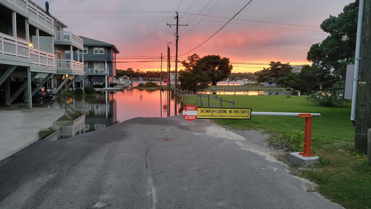
While sunny day flooding sounds counterintuitive, it is a chronic issue coastal communities are facing more often, especially during king tides.
“As local sea-level rise, land subsidence, and development continue to increase in coastal areas, so does the frequency of flooding,” the project website explains. “The tidal cycle now takes place on higher average sea levels, resulting in ‘sunny day’ flooding of roadways during high tides. Sea water also infiltrates stormwater drainage systems at normal tidal levels, such that ordinary rainstorms lead to flooding. While these minor floods draw less attention than catastrophic storms, their high frequency imposes a chronic stress on coastal communities and economies by disrupting critical infrastructure services.”
Two of the project’s leaders, scientists Katherine Anarde and Miyuki Hino, told Coastal Review in an email response that sunny day flooding is inundation that happens without any rain or storm taking place.
Anarde is an assistant professor in North Carolina State University’s Department of Civil, Construction and Environmental Engineering, and Hino is an associate professor in University of North Carolina Chapel Hill’s City and Regional Planning and an adjunct assistant professor in the Environment, Ecology, and Energy Program.

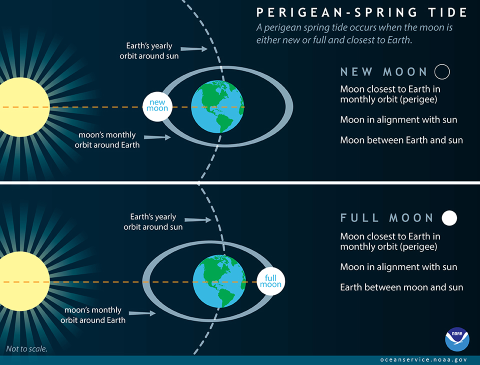
“It can be a perfectly sunny day, but due to tides or wind, water levels in the ocean are high enough to cause flooding,” they explained. “King tides occur during the coincidence of perigee and spring tides – when the moon is closest to Earth in its orbit and in alignment with the Sun, which exerts the largest tide generating force on the world’s oceans.”
Supporter Spotlight

The Sunny Day Flooding Project launched in 2021 “to understand and address the incidence and impacts of chronic coastal flooding, which includes sunny day floods but also ‘flash floods’ from routine rain events coinciding with high tides” and is currently funded by the National Oceanic Atmospheric Administration, the National Science Foundation and NASA, or the National Aeronautics and Space Administration.
“We partner with communities to monitor how often floods are occurring, measure their impacts, and evaluate potential adaptation responses,” Anarde and Hino explained.
The team collects measurements, holds interviews and conduct surveys to better understand the effect of floods on residents, economies and human health. They communicate the flood risks through its flood alert system and king tides program.
While king tides “are not a new phenomenon,” the higher sea levels combined with sinking land, called subsidence, allows tides to rise relatively higher and higher, inundating low-lying infrastructure that was built decades ago, they said.
“The most visible impact is flooding on roads, often due to water backing up through stormwater drainage networks. However, the high water levels can also affect other aspects of infrastructure, such as septic tanks and underground sewage pipes,” the two continued.
A now-retired researcher at UNC Institute of Marine Sciences based in Morehead City started about a decade ago the North Carolina King Tides Project to study the floods that historically occurred during king tides, in association with the international King Tides Project. The global initiative began in Australia in 2009 and asked the public to document and share their photos showing how these higher tides affect shorelines.
North Carolina’s project began releasing a calendar with predicted high tides and encouraged the community to photograph and submit their observations of shoreline water levels.
The Sunny Day Flooding Project absorbed the N.C. King Tides Project after the researcher retired a few years ago and now publishes the calendar of when to expect king tides each year. The project also encourages the public to upload photos and details through the free Coastal Observer app.
The first king tide of this year was April 17-19, the current king tide is supposed to end Thursday, and more are expected June 13-16, July 12-15, Aug. 10-13, Oct. 25-31, Nov. 23-27, and Dec. 24-25, according to the calendar.
The calendar notes king tides as well as amplified tides, which they define as a nonscientific term for when higher and lower water level events are expected that “result when perigee and spring tides almost co-occur, yet are offset by a day or more.”
On the project website, the team offers the caveat that the calendar “does not predict coastal flooding.” Floods are often caused by wind and pressure, seasonal changes in sea level, and land-based factors like high groundwater, rainfall, and existing infrastructure.
“With sea-level rise, flooding during the perigean spring tides has become more and more common, but flooding is also occurring during moderate tidal cycles in some communities,” the website states.
Researchers recommend checking the NOAA Monthly High Tide Outlook for flooding probabilities.
The team also communicates flood risks through its flood alert system available for Beaufort, Carolina Beach, Down East and New Bern, where there are water level sensors. Those interested can sign up to receive an email whenever water levels overtop the roadway at the chosen sensor location.
On the project website, researchers explain that the chronic flooding affects people differently than extreme events like hurricanes because it is not as deep and widespread as storm surges from hurricanes, but it is more frequent. The high rate of constant flooding interrupts travel and could also increase infrastructure maintenance costs for coastal communities.
Anarde and Hino said that there are ways to address the impacts of chronic coastal floods, and the right response is going to differ from place to place.
“Elevating infrastructure can help keep it dry and reduce damage from saltwater. Scheduling trips to avoid the highest tides can help avoid flooded roads and keep travelers safe. Given that this type of flooding is projected to become more frequent in the future, it’s important to consider both immediate, short-term responses and longer-term strategies,” they said.