The Duncan House at 105 Front St. in Beaufort, a structure that dates back to the mid-1700s, is listed on the National Register of Historic Places and is one of only 11 properties in North Carolina designated as Statewide Properties of Significance, is cordoned off Tuesday after a blaze consumed the unoccupied building on Monday. Photo: Dylan Ray
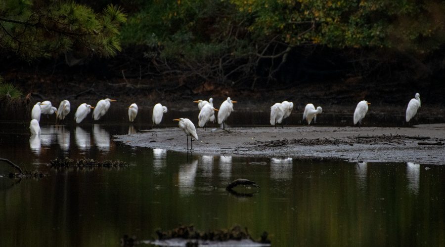
Ruffled feathers hunker together
A siege of herons takes refuge Monday from high winds near Russell Creek in Beaufort. Photo: Dylan Ray
Pick of the pumpkin patch
Barbara Johnson of Morehead City carries a pumpkin Thursday across the grounds the First Presbyterian Church at 1604 Arendell St. Held every October, the fundraising event that benefits the children and youth ministry program is from 10 a.m. to 6 p.m. Monday through Saturday and noon to 6 p.m. on Sunday until Oct. 31. Photo: Dylan Ray.
Distant storms churn up surf along NC coast
Storm swell associated with Hurricane Imelda and Hurricane Humberto breaks Tuesday along the Bogue Banks shore at Oceanana Fishing Pier in Atlantic Beach. The storm, while moving away from the U.S. Tuesday, still packed a potent punch, forecasters said, and could bring possible minor flooding in areas of onshore winds along the coast in the Southeast. At 11 a.m. Tuesday, the storm was moving to the northeast, toward near Bermuda, but swells and high surf from Imelda and Hurricane Humberto were expected to produce dangerous marine conditions and rip currents along much of the East Coast for several days. Farther north, the N.C. Department of Transportation on Tuesday closed N.C. 12 on the north end of Ocracoke Island between the National Park Service Pony Pens and the ferry terminal due to deteriorating travel conditions and five oceanfront houses collapsed on Hatteras Island. Photo: Dylan Ray
Wild herd, long shadows
Wild horses cross tidal waters from Town Marsh to Bird Shoal along Beaufort’s barrier islands, which are part of the Rachel Carson Reserve, in Carteret County. The cluster of islands includes Carrot Island, Town Marsh, Bird Shoal, and Horse Island, and the horses are descended from those brought to the islands by a Beaufort area resident in the 1940s, according to the North Carolina Department of Environmental Quality. The state manages the horse population for its health and for the health of the environment, but the herd is otherwise left to fend and forage for itself. Photo: Dylan Ray
Night flyer out on a limb
A male luna moth, or Actias luna, finds a perch in the branches of a Japanese maple near Russell Creek in Beaufort. The easily identified species flies mostly at night and is found statewide this time of year in and near hardwood forests, wooded residential areas and, on North Carolina’s barrier islands, in maritime forests. Adult luna moths do not feed and live off food they consumed as caterpillars for the moths’ seven- to 10-day lifespan.
Avon inbound
The North Carolina Department of Transportation Ferry Division vehicle ferry Avon prepares to dock at the Minnesott Beach Ferry Terminal in Pamlico County, making one of the service’s numerous daily, 20-minute trips each way, back and forth between here and the Cherry Branch terminal across the Neuse River in Craven County. The Avon is one of 21 state ferries serving commuters and visitors on seven routes across the Neuse, Cape Fear and Pamlico rivers, and the Currituck and Pamlico sounds, and their schedules vary seasonally. Photo: Dylan Ray
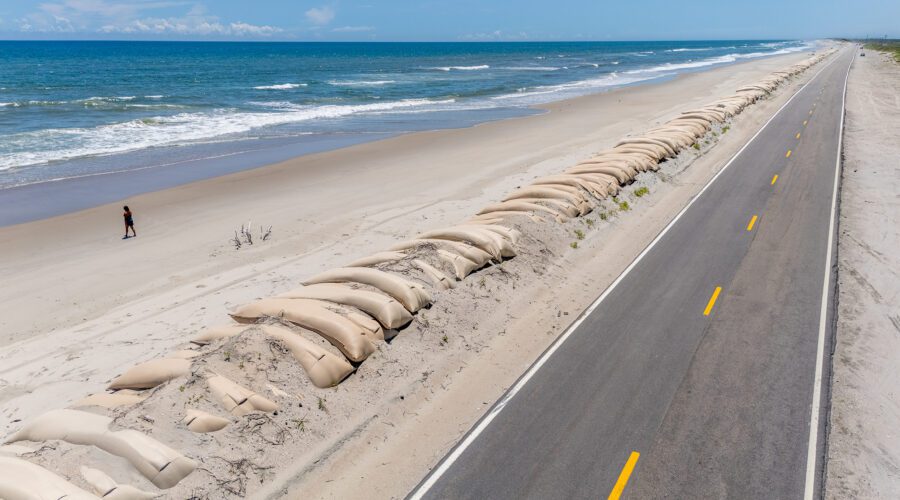
Shifting sands
A wall of sandbags extends along the roadside far into the distance aside N.C. Highway 12 on the north end of Ocracoke Island. This is where washouts and erosion from storm surge repeatedly chew away at the barrier island beach and roadway, part of the normal ocean dynamics that humans often try to control. Photo: Dylan Ray
Sexy flex
An anole sends out a message to potential mates by flexing his throat to reveal a show of color in a Beaufort garden. Photo: Dylan Ray
Coastal calf suns on a bed of flowers
A calf lies in a field of spring flowers near the Haystacks area of Morehead City in Carteret County. Photo: Dylan Ray
US 70 bridge inspection in progress, plan for daytime delays
A state Department of Transportation crew works high above the Newport River Tuesday inspecting the underside of the Morehead City-Beaufort high-rise bridge next to the state port. Traffic delays were expected through Friday on this part of U.S. Highway 70 as one lane of travel was planned during daylight hours, or 8 a.m. – 5:30 p.m. Photo: Dylan Ray
Top job
Paint crews work high above the deck of the NC State Port of Morehead City Thursday as a new protective coating is applied to the water tower. Photo: Dylan Ray
Apart from the rest
A lone cypress stands apart from those closer to the shoreline at the old mill pond in Carteret County that was originally part of a tract owned by Welshman Robert Williams, who settled in Carteret County in 1763. Williams created the mill pond by having a dam built on Black Creek. A gristmill and a sawmill operated at each end of the dam, which is now below a bridge span on Mill Creek Road. Williams was also one of two county landowners whom historians say received money to build salt works in the county to assist in the Revolution. Photo: Dylan Ray
Not fog of war
Fog blankets the cannons Monday at Fort Macon State Park at the east end of Bogue Banks in Carteret County. Built during the decade after the War of 1812 to defend Beaufort Inlet, the fort was taken by Union forces early during the Civil War and was never again relinquished to the Confederates. Fort Macon is one of the state’s most visited parks, welcoming more than a million visitors annually. Photo: Dylan Ray
Blanket of white falls overnight
Snow covers Front Street in Beaufort Wednesday morning as the winter storm continues to blanket Carteret County and much of coastal North Carolina. Photo: Dylan Ray
By land or by sea
Kevin Hardy of Wilmar, near Vanceboro, fishes along Cape Lookout National Seashore as a commercial fishing trawler offshore heads southwest. Photo: Dylan Ray


