Updated at 5:45 p.m.
Supporter Spotlight
A hurricane warning is in effect for the entire North Carolina coast, including Albemarle and Pamlico sounds.
Dorian is forecast to move near or over the coast of South Carolina and North Carolina Thursday through Friday.
The National Hurricane Center said Wednesday afternoon that satellite imagery showed significant cooling in the cloud tops in the eye wall in recent hours, with the eye becoming better defined. But forecasters noted newer reports from an Air Force Reserve Hurricane Hunter aircraft that show little change in intensity.
As of 5 p.m. Wednesday, the center of Hurricane Dorian was at 30.6 degrees north, 79.8 degrees west, or about 275 miles south-southwest of Wilmington with maximum sustained winds of 110 mph. and moving north-northwest at 8 mph.
Life-threatening storm surge and dangerous winds are expected to reach the North Carolina coast, regardless of the exact track of Dorian’s center. There is a high risk of flash flooding on Thursday across coastal sections from northeast South Carolina into southern North Carolina.
Supporter Spotlight
A storm surge warning is in effect for Pamlico and Albemarle sounds and the Neuse and Pamlico rivers. A storm surge warning means there is a danger of life-threatening inundation, from rising water moving inland from the coastline, during the next 36 hours.
Forecasters said the combination of a dangerous storm surge and the tide will cause normally dry areas near the coast to be flooded by rising waters moving inland from the shoreline. The water could reach 4 to 7 feet above ground from the Savannah River to Cape Lookout if the peak surge occurs at the time of high tide and 3 to 5 feet from Cape Lookout to Duck, including Pamlico and Albemarle sounds and the Neuse and Pamlico rivers.
Here’s the latest rainfall 5-day rainfall forecast from @NWSWPC for #Dorian. For specific details in your area, see https://t.co/SiZo8ozBbn pic.twitter.com/0GoPpHog6a
— National Hurricane Center (@NHC_Atlantic) September 3, 2019
Rainfall amounts are forecast to total 5 to 10 inches, with isolated amounts of 15 inches along the Carolina coast.
A tropical storm watch is in effect for the North Carolina-Virginia border to Chincoteague, Virginia.
Dorian is forecast to continue to pick up speed toward the northwest or north-northwest through early Wednesday. A turn toward the north is forecast by Wednesday evening, followed by a turn toward the north-northeast on Thursday morning. On this track, the core of Hurricane Dorian will move dangerously close to the Florida east coast and the Georgia coast through Wednesday night. The center of Dorian is forecast to move near or over the coast of South Carolina and North Carolina Thursday through Friday morning.
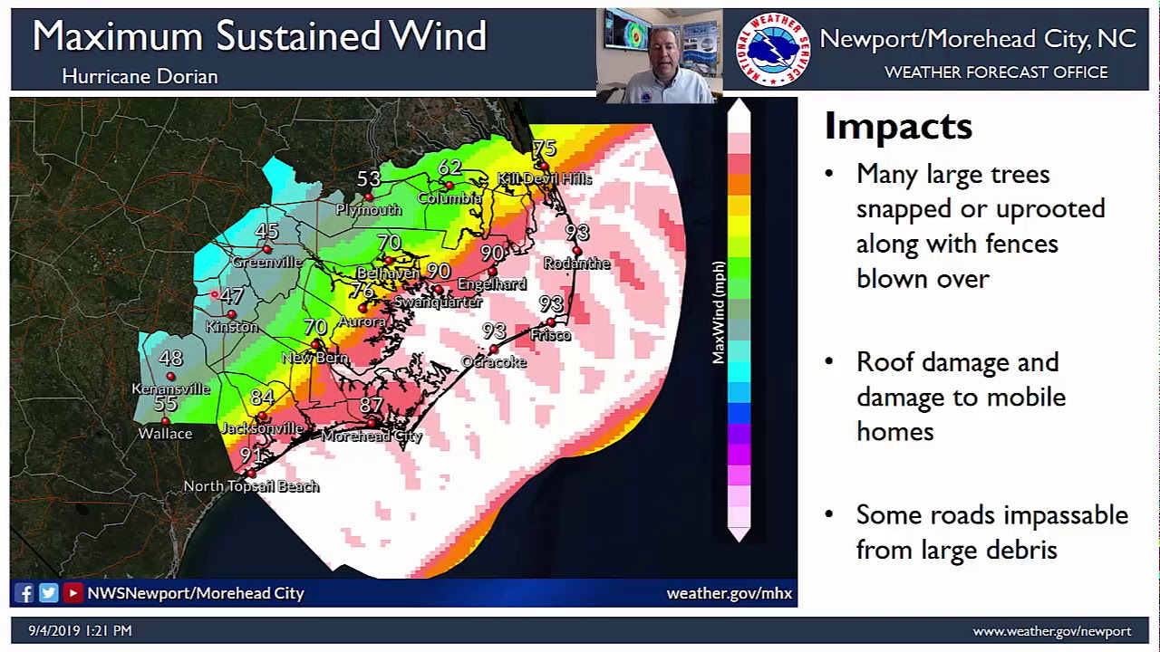
A video update from the National Weather Service’s Newport/Morehead City office.
Gov. Roy Cooper issued on Tuesday a mandatory evacuation order effective 8 a.m. Wednesday for North Carolina’s barrier islands. County and municipal governments in coastal areas have also issued mandatory and voluntary evacuations.
“Please heed any evacuation orders from local emergency officials where you live,” said Cooper. “Don’t try to ride it out. You’re putting your life at risk. You’re also putting at risk the lives of first responders who may have to rescue you.”
North Carolina Emergency Management has opened shelters in other areas of the state, including locations that are pet-friendly. For updated shelter information, visit the website.
The federal government granted Cooper’s request for a federal disaster declaration for North Carolina Tuesday.
Cooper said more than 300 North Carolina National Guard soldiers were moving into positions in armories across the state. Water rescue teams were moving to staging areas closer to the coast.
Emergency management officials urge residents to follow local news for the latest advisories from the National Weather Service and National Hurricane Center as well as state and local emergency management officials.
Officials also recommend preparing to lose power for an extended period, have well-stocked emergency supply kits with enough bottled water and nonperishable food to sustain each family member for three to seven days and to plan for your pets.
County Evacuations
Currituck County officials issued a mandatory evacuation of Corolla and Carova beginning at 8 a.m. Wednesday. Those needing evacuation assistance should call Currituck Emergency Management at 252-232-2115.
In Dare County a mandatory evacuation order is in effect for visitors and a mandatory evacuation order for residents goes into effect at 6 a.m. Wednesday. Emergency Management strongly urges everyone to heed the warning and evacuate. Those who do not evacuate should be prepared to sustain themselves for at least 72 hours. Emergency personnel will not be able to respond to calls for help during the flooding and high winds that are expected during this storm. Transportation to a shelter in Rocky Mount was made available for Dare County residents Wednesday. Subscribe to receive emergency alerts via text, email or phone directly from Dare County Emergency Management and follow @DareCountyEM on Twitter. All Criminal, Civil and Magistrates Court scheduled for Wednesday, Thursday, and Friday are canceled. New court dates will be scheduled and notifications sent out on or after Monday.
In Hyde County, a mandatory evacuation for residents takes effect at 5 a.m. Wednesday. A shelter will open at noon Wednesday at Northampton County Cultural and Wellness Center, 9536 N.C. 305, Jackson, for evacuees. Pets are allowed at this shelter. Please bring vaccination records and a kennel if you are traveling with your pets. Anyone with special medical needs that need to evacuate should contact the EOC at 252-926-3715 for guidance. Hyde Transit will be assisting those who need aid with evacuation transportation. Details can be found online. A curfew will be in effect for Ocracoke Island 10 p.m.-6 a.m. starting Wednesday. A ban on alcohol sales will begin at 4 p.m. Wednesday for Ocracoke and 4 p.m. Thursday for the mainland. The Hyde County Emergency Operations Center can be reached at 252-926-3715. If you need assistance with evacuation transportation call Hyde Transit at 252-926-1637. If you have an emergency call 911. Hyde County government offices will be closed from Wednesday through Friday. All Hyde County convenience sites will close at noon Wednesday. The county commissioners meeting scheduled for Tuesday is postponed.
The final ferry departure from Ocracoke to Swan Quarter will be at 3:45 p.m. Wednesday, the final departure from Ocracoke to Cedar Island will be at 1 p.m. Wednesday and the final departure from Ocracoke to Hatteras will be at 2 p.m. Wednesday.
In Tyrrell County a voluntary evacuation takes effect at 8 a.m. Wednesday.
Washington County has called for voluntary evacuation of low-lying areas.
Craven County issued a voluntary evacuation order to go into effect 2 p.m. Wednesday for those living in low-lying areas with a history of extreme flooding. Extreme wind, storm surge, rainfall and river flooding is expected in the Neuse and Trent river basins in Craven County as early as Wednesday evening, officials said. Craven County Emergency Shelters will open at 4 p.m. Wednesday in Havelock High School, 101 Webb Blvd.; Creekside Elementary, 2790 Landscape Drive, New Bern; Ben D. Quinn Elementary, 4275 Martin Luther King Blvd., New Bern, pet friendly; and Farm Life Elementary, 2000 Farm Life Ave., Vanceboro. For more information on emergency shelters call Craven County Emergency Management at 252-636-6608. Craven County Government Emergency Management updates will appear on the Craven County website, on the Craven County Facebook page @cravencounty and the Craven County Emergency Management Twitter account @cravencountync.
Pamlico County Emergency Management issued a voluntary evacuation beginning at 8 a.m. Wednesday. The county emergency operations center will begin 24-hour operations Wednesday. A shelter is to open at 8 p.m. Wednesday in Pamlico Community College. Animals are permitted but will be housed in a separate building under the supervision of the county animal control.
Carteret County issued a mandatory evacuation starting at noon Wednesday for North River, South River, Down East, and residents in manufactured homes including park models, recreational vehicles and mobile homes. The Emergency Operations Center will be open at 8 a.m. Wednesday. For general information, call 252-726-7061. Carteret County Emergency Management anticipates the shelter at the Newport Middle School, 500 E. Chatham St., Newport, will open at noon Wednesday.
Atlantic Beach is under a mandatory evacuation and town officials encouraged residents and visitors to be in a safe place and sheltered by 10 a.m. Thursday. A re-entry pass may be required after the storm, depending on the degree of damage and condition of property damage and roadways. Effective 7 p.m. Thursday, access to Atlantic Beach will be restricted until further notice A town-wide curfew will be in effect starting at 7 p.m. Thursday. During curfew, it is illegal for anyone to leave their own property and travel anywhere within Atlantic Beach. Only essential personnel will be permitted on public roadways.
Beaufort has issued a mandatory evacuation that began at 3 p.m. Tuesday. All residents should be at a safe location by early Wednesday evening, according to town officials.
A mandatory evacuation for Emerald Isle goes into effect at 8 a.m. Wednesday. All residents, property owners and visitors should evacuate no later than 7 p.m. Thursday, when access to Emerald Isle will be restricted until further notice. Alcohol sales will cease at 11:59 p.m. Wednesday and will remain suspended until further notice. There is a town-wide curfew effective 7 p.m. Thursday. Only essential personnel are permitted on the roadways. During the curfew, it is illegal for anyone to leave their own property and travel anywhere within Emerald Isle. The Emerald Isle Bridge is to close at 10 a.m. Thursday and will remain closed until town officials determine it is safe.
Pine Knoll Shores’ mandatory evacuation takes effect at 8 a.m. Wednesday. Evacuees should reach their safe location by 8 p.m. Wednesday. The town’s beaches will be closed 8 a.m. Wednesday until further notice. The town hall will be closed Thursday and Friday.
Cape Carteret’s mandatory evacuation takes effect at noon Wednesday. A curfew takes effect at 6 p.m. Thursday.
Onslow County has called for a voluntary evacuation for the unincorporated areas of the county. The county will open shelters starting at 7 a.m. Thursday at Jacksonville Commons Middle School, Dixon Middle School, Swansboro High School and Richlands High School.
Pender County will open three shelters at 2 p.m. Wednesday in Cape Fear Middle School, Malpass Corners Elementary and Topsail Elementary. Cape Fear Middle School is the pet-friendly shelter. Pet owners are required to present rabies vaccination records. Residents need to bring pet food and water and carriers. Residents who are listed on the special-needs registry should contact the health department at 910-259-1230. Pender County Emergency Management will post updates on the Facebook page and on the website. If you need assistance call the EM office at 910- 259-1210.
Topsail Beach commissioners issued a mandatory evacuation for all visitors and a voluntary evacuation for owners and residents effective 2 p.m. Tuesday. The voluntary evacuation for owners and residents will become mandatory at noon Wednesday. There is an 8 p.m. curfew for Wednesday.
New Hanover County issued Tuesday a mandatory evacuation order beginning at 8 a.m. Wednesday for residents and visitors of Carolina Beach, Kure Beach, Wrightsville Beach and Figure Eight Island. Residents in areas prone to flooding or storm surge and those in travel trailers, mobile homes or homes still damaged from Hurricane Florence are under a voluntary evacuation beginning at 8 a.m. Wednesday. Residents and visitors should evacuate and be in a safe location before 8 p.m. Wednesday. Residents near major waterways and near many of the county’s creeks are under voluntary evacuation because of the expected 1- to 3-feet of storm surge, with potential of higher localized areas near Cape Fear River and the Intracoastal Waterway.
“This is not the same type of rain event we saw with Hurricane Florence, but we have residents who are still in temporary housing or homes that can’t yet withstand the impacts of another storm,” said New Hanover County Emergency Management Director Steven Still. “Two shelters will open Wednesday and our partners are in the community helping Hurricane Florence survivors have their plan in place by Wednesday evening.”
New Hanover County will open emergency shelters at 10 a.m. on Wednesday at Codington Elementary School, 4321 Carolina Beach Road, Wilmington and Blair Elementary on Blair School Road. The pet-friendly shelter is at 6510 Market St., Wilmington. House cats and dogs brought to the shelter will be kept in a separate wing of the facility, and owners are allowed visitation at designated times. Those seeking emergency shelter should bring their own blankets and pillows, prescription medications and other necessary items like extra clothing and hygiene supplies. No alcohol, illegal drugs or weapons are permitted. There will be limited food service available for people seeking shelter. The public can call the Emergency Public Information Center with questions about shelters, evacuation orders, protective measures, or current notices at 910-798-6800.
Brunswick County is to open three shelters at 8 a.m. Wednesday. Beginning at 8 a.m. Wednesday is the voluntary evacuation for unincorporated areas and the mandatory evacuation for the communities of Bald Head Island, Caswell Beach, Oak Island, Holden Beach, Ocean Isle Beach and Sunset Beach.
All pet friendly, shelters are at North Brunswick High School, 114 Scorpion Drive, Leland; West Brunswick High School, 550 Whiteville Road, Shallotte; and South Brunswick High School, 280 Cougar Road, Boiling Spring Lakes.
The Brunswick County Government Complex and Brunswick County Courthouse are closed Wednesday through Friday. All court sessions are canceled and all rescheduled cases will receive notice of their new hearing dates by USPS.
Oak Island issued a voluntary evacuation for low-lying areas and a mandatory evacuation for visitors/tourists. Reentry information is available on Oak Island’s website.
The governor’s office has activated the North Carolina Disaster Relief Fund for donations to support North Carolina’s response to Hurricane Dorian.
Duke Energy says precautions in place
Duke Energy said teams had taken the necessary steps to prepare the facilities for Dorian. A spokesperson for the utility said Tuesday that its coal ash basins in North Carolina had performed well through recent hurricanes.
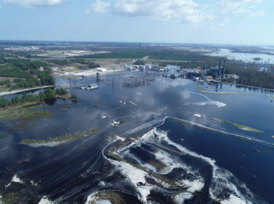
Soon after Florence, Duke Energy reported that about 2,000 cubic yards of soil and ash had spilled from the landfill at L.V. Sutton Power Station in Wilmington. Samples collected by researchers from Duke University showed an unexpectedly high magnitude of contaminants that indicated a much larger release. The company at the time called the researchers’ findings “ludicrous.”
Paige Sheehan with Duke Energy Corporate Communications provided a statement that the utility had plans in place to minimize potential effects from the storm and to ensure there is adequate staffing, supplies and equipment in place. Also, she said, the utility was “well down the path to safely closing ash basins” and that sites in the path of the storm already have lower water levels in the basins and could hold significant rainfall.
“At the retired Sutton Power Plant in Wilmington, basins have been excavated and the material moved to a lined landfill on plant property. Anticipating future storms, a special synthetic turf is being used to cap each landfill cell because it provides additional protection against erosion and strong winds that are known in the region. The turf is rated to withstand winds of 120 mph or a Category 3 hurricane,” Sheehan said.
She said that in response to flooding caused by recent hurricanes, the company had expanded or built new emergency spillways at cooling ponds, which do not store coal ash, at three facilities near the coast, the H.F. Lee, Weatherspoon and Sutton plants, to safely move water through the system if necessary in order to prevent damage to the facilities.
EPA ready to help
The Environmental Protection Agency said it is working with local, state, tribal and federal agencies to be ready to assist. EPA Region 4 based in Atlanta has also identified the list of potentially affected Superfund sites, including ones in North Carolina. In addition to the EPA liaisons supporting the Federal Emergency Management Agency’s Regional and National Response Centers, EPA said it would provide water sector support for the Army Corps of Engineers at the Florida, Georgia, North Carolina and South Carolina emergency operation centers in the coming days, pending federal declarations of emergency.
Avoid Swimming After Storm
State recreational water quality officials are advising the public to avoid swimming in all coastal waters of North Carolina following Hurricane Dorian until testing indicates bacteria levels meet state and federal standards. Testing will begin as soon as conditions are safe to do so and areas are accessible, according to the state Department of Environmental Quality.
“Severe weather events like hurricanes can bring excessive amounts of rain and cause extreme flooding. These conditions increase levels of harmful bacteria in our coastal waters that can cause illness,” said Erin Bryan-Millush, manager of the N.C. Recreational Water Quality Program. “The source of bacteria varies from failing septic systems, sewer line breaks, overflowing manholes and wildlife.”
While state officials will not have immediate laboratory confirmation that disease-causing organisms are in the water, there is an increased chance that contamination will be present following the storm, and those swimming in these waters have an increased chance of adverse health effects.
Residents and visitors should avoid swimming in all coastal waters until testing indicates bacteria levels meet state and federal standards. Testing will begin as soon as conditions are safe to do so and areas are accessible. The advisory will be lifted in part or in whole as test results become available.
Recreational Water Quality officials test for enterococci, which is a bacteria group found in the intestines and fecal matter of warm-blooded animals. While it is not known to cause illness, scientific studies show that enterococci may indicate the presence of other disease-causing organisms such as e-coli, salmonella, norovirus.
Because waters affected by the storm likely will be widespread, signs will not be posted.
Recreational water quality officials sample 209 sites throughout the coastal region, most of them on a weekly basis from April to October. Testing continues on a reduced schedule during the rest of the year, when waters are colder.
Shellfish Harvest Closures
All state coastal waters will temporarily close to shellfish harvest at sunrise Thursday due to the impending impacts of Hurricane Dorian.
The state Division of Marine Fisheries in an announcement Wednesday explained that the National Hurricane Center prediction that Hurricane Dorian will produce rainfall accumulations of 5 to 10 inches across the coast, with localized rainfall of 15 inches possible.
The excessive rainfall could cause stormwater runoff, flooding, sanitary sewer malfunctions and lift station failures that increase contaminants in the water. Shellfish feed by filtering particles from the water. As the shellfish feed, they also concentrate any pathogens in the water, which can be harmful if consumed.
The division could reopen the waters quickly if portions of the coast do not experience the expected rainfall amounts or other impacts from the storm. Staff will assess impacts and test the waters before reopening them to shellfish harvest.
Coastal Review Editor Mark Hibbs, Assistant Editor Jennifer Allen and reporter Trista Talton contributed to this report.


