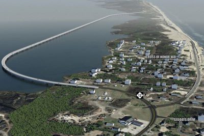
CAPE HATTERAS NATIONAL SEASHORE — The state Department of Transportation’s plan to build a portion of the new “jug handle” bridge through a portion of Cape Hatteras National Seashore was approved by the National Park Service, or NPS.
The NPS announced last week that a special use permit and highway easement deed will be issued by the NPS for NCDOT’s construction of a 2.3 mile-long bridge, partially located within Cape Hatteras National Seashore.
Supporter Spotlight
Robert Vogel, the director of the Southeast Region of the National Park Service, signed the Finding of No Significant Impact, or FONSI, completing the National Environmental Policy Act and National Historic Preservation Act reviewing and consulting requirements.
Construction has begun outside of the park service boundaries on the 2.3 mile bridge that is part of a suite of long-term transportation solutions on Hatteras Island.
The new bridge will reroute NC 12 in the Pamlico Sound to avoid the “S Curves” area at Mirlo Beach in Rodanthe, an area that routinely experiences ocean overwash, according to the release. About 150 feet of the 2.3 mile-long bridge, located at the northernmost section of sound side construction adjacent to Pea Island National Wildlife Refuge, will be inside park boundaries. The remainder of the bridge will be built within the refuge and submerged lands owned by the State of North Carolina.


