This story has been updated.
WILMINGTON – Beams of sunlight broke through dark gray storm clouds suspended in the sky above this historic city on a recent August morning.
Supporter Spotlight

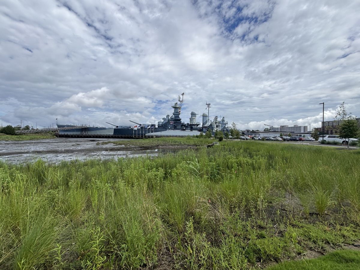
The local forecast was calling for rain, the kind of weather that drives tourists from area beaches to explore other experiences the area has to offer. The kind of weather that makes for a busy day at the Battleship North Carolina, the iconic floating World War II memorial moored on the Cape Fear River across from downtown Wilmington.
“This parking lot will be full in another hour,” said Terry DeMeo, the battleship’s director of development.
A year ago, DeMeo might not have made that prediction with as much certainty.
Back then, floodwaters overspilling from the Cape Fear River might have swallowed dozens of parking spaces in the western portion of the parking lot and forced visitors to make a decision: wade through water to get to the museum’s visitor center or head for higher ground.
That’s not much of a worry these days.
Supporter Spotlight

A wetland has been built in place of the chronically flooded section of parking lot to help absorb high-tide driven water. A tidal creek now meanders through this area of the property to direct water from the wetland back to the Cape Fear River.
A 500-foot-long and 50-foot-wide bioretention area extends through a paved, raised parking lot that has, since its completion Memorial Day weekend, gone untouched by floodwaters.
A bioswale runs the length of the parking lot next to Battleship Road. Living shorelines blend in with the rest of the natural, wild landscape around the ship’s mooring.
These features are all part of the battleship’s “Living with Water” project, one that accommodates the water rather than try and fight it back.
Construction on the project, some seven years in the making, is mostly complete.
Land next to the battleship has become a well-known and well-documented case in point on the impacts of sea level rise.
Since the memorial opened to the public in 1961, flood events on the property have climbed on a near-steady incline. Over the past six decades, a more than 7,000% increase in tidal flooding frequency has been documented at the site.
Flood events spurred by the rising sea created a sense of urgency for the museum’s leaders. The memorial does not receive regular government funding.
Persistent flooding of the property threatened one of the primary sources of the battleship’s funding – admission fees and gift shop sales.
“We actually lost parking, but that’s how committed we are to this project,” DeMeo said as she looked across the parking lot.
The lot sits at an elevation 6 feet above the old gravel one it replaced earlier this year.
The parking lot slopes to a bioretention area that looks as much like a pleasing water feature as it does a functional holding area for stormwater that allows water to percolate down into the soil.
A total of 450 spaces were at the memorial before the project was built. Today, there are 150 fewer parking spaces on the property.
Of those parking spaces, 100 were unusable due to flooding of the western portion of the old parking lot, DeMeo said. Plans are in the works to finish an overflow lot that may add roughly another 55 spaces.
“So, discounting the unusable old spaces, we expect to come out about even,” DeMeo said later in an email.
The loss of spaces has been a small price to pay for the multimillion-dollar project, one funded through federal and state grants, including the National Fish and Wildlife Foundation, National Oceanic and Atmospheric Administration, U.S. Fish and Wildlife Service, and the North Carolina Land and Water Fund, as well as the USS North Carolina Battleship Commission, Atlantic Coastal Fish Habitat Partnership, and numerous individual donors.
Within days of the wetland and tidal creek’s completion, birds moved in on the area, DeMeo said.
“That’s been pretty amazing to see the avian community step in right away, which means fish were in there,” she said. “That’s also when we saw the diminution of walking through knee-high flooding.”
The land, she explained, has been able to recreate itself.
The site now hosts researchers from NOAA as well as the University of North Carolina Wilmington, who are monitoring everything from the physical and vegetative parameters of the area to water quality.
The museum’s leaders are now in the early stages of exploring the creation of a living lab partnership with the university and NOAA.
A living lab is a natural fit, “and it’s a way to keep an eye on the project itself,” DeMeo said.
“This is a long-term project,” she said. “We don’t know where it’s ending. We consider ourselves a model for how this can be done and how it can’t be done. We really see ourselves as an opportunity to use as a case study. We had the opportunity and we had the need. That’s why we feel so strongly about serving as a model.”