Coastal communities along the Atlantic, Caribbean and Gulf coasts can now better assess changing flood risks using a newly released model created by the National Ocean Service.
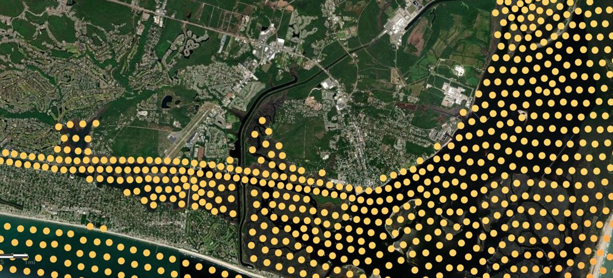
The service, which falls under the National Oceanic and Atmospheric Administration, on Monday launched Coastal Ocean Reanalysis, or CORA, a dataset that includes more than four decades of modeled and historical water level and wave information roughly every quarter mile along the U.S. coastline.
Supporter Spotlight

CORA closes what have been in some areas of the coast huge gaps in water level data collection that left some coastal communities without such information. That’s because historical data was until today available at NOAA’s tide gauge locations, which can be hundreds of miles apart along some areas of the coast.
“Historical coastal water level information is necessary to assess changing flood risks to communities and to predict the likelihood of flooding,” National Ocean Service Director Nicole LeBoeuf said in a release. “This new dataset will improve NOAA’s current flood-risk assessment tools and help scientists develop new coastal flood products and services for the nation.”
The information provided in CORA can help advance coastal flood planning for everyone from local government planners, engineers, and flood management professionals.
“CORA provides coastal communities with new insights into how their flood risk has changed over time,” Analise Keeney, project lead and oceanographer at NOAA’s Center for Operational Oceanographic Products and Services, stated in a release. “In Charleston, South Carolina, for example, CORA shows the full extent of the devastating inland flooding caused by Hurricane Hugo in 1989. Combined with NOAA’s long-term tide gauge data, the data enables more coastal communities to understand their past flood risks so they can better prepare and respond to future events.”
CORA’s historical datasets will be merged into tools including the Sea Level Calculator and High Tide Flooding Outlooks, and used by NOAA scientists to model monthly high tide flooding predictions every 500 meters along the coast to provide more communities with timely information about their flood risks.
Supporter Spotlight

NOAA’s Office of Water Prediction is also collaborating with NOS to pair CORA dataset with the National Water Model to help make coastal flood inundation mapping more robust.
CORA datasets for the West Coast, Hawaii and Alaska are expected to be released in late 2026.
CORA is available for public download through NOAA’s Open Data Dissemination platform. Additional information, maps, and related resources are available on NOAA’s Tides and Currents website.
CORA was made possible through collaboration with the University of North Carolina’s Renaissance Computing Institute. The model was validated by the University of Hawaii’s Sea Level Center.
CORA is a community-based modeling effort made possible through collaboration with the University of North Carolina Chapel Hill’s Renaissance Computing Institute. Modeling validation was conducted by the University of Hawaii’s Sea Level Center.