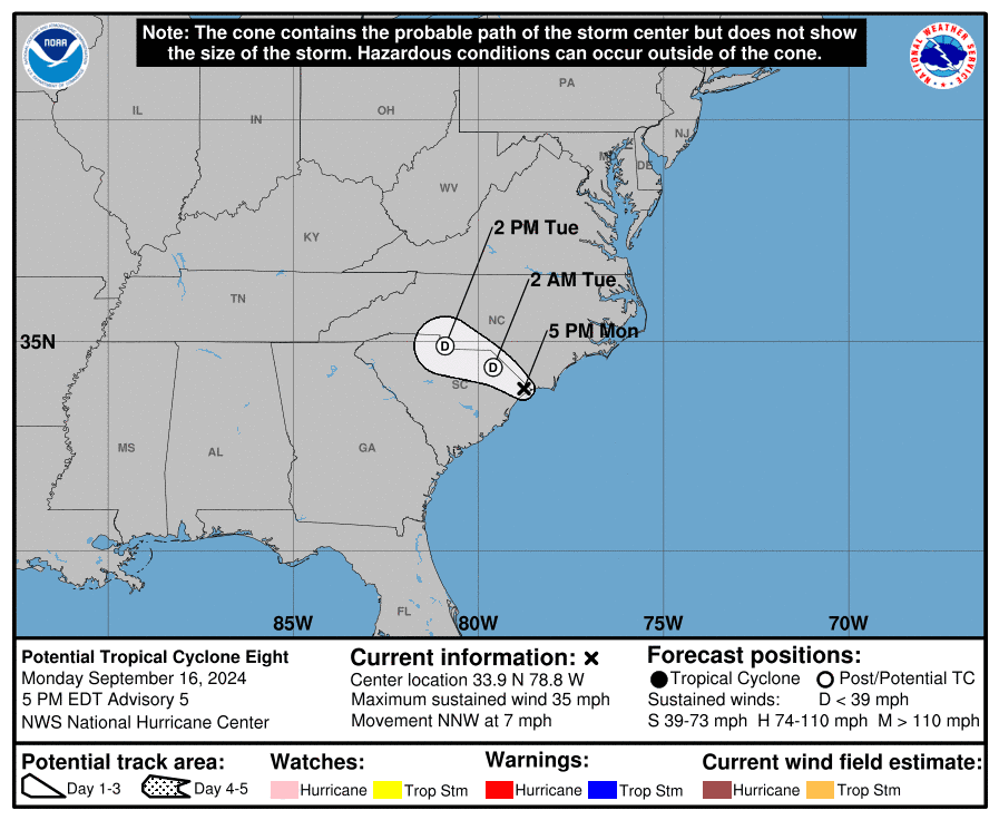
Regardless of whether potential tropical cyclone No. 8 becomes a subtropical or tropical storm before it makes landfall on the South Carolina coast late Monday, Eastern North Carolina residents were already feeling and will continue to feel the effects of the low-pressure system.
All tropical storm warnings had been discontinued and there were no coastal watches or warnings in effect, as of the 5 p.m. Monday update from the National Weather Service.
Supporter Spotlight
At that time, the storm was about 45 miles west of the Cape Fear region, with maximum sustained winds of 35 mph. The center of the storm was around 33 degrees, 9 minutes, north latitude and 78 degrees, 8 minutes west, longitude.
The low-pressure system was expected to reach the coast of South Carolina Monday evening and then move inland across the Carolinas through Wednesday. The low was forecast to dissipate by early Wednesday.
“The main threat will be periods of heavy rain with storm total rainfall amounts of 3 to 6 inches, with locally higher amounts possible. The highest rainfall totals are expected for areas south of Highway 70. This will bring the threat of localized flash flooding especially in low-lying, urban, and poor drainage areas,” forecasters said Monday morning. Rain over the past week will make some areas more susceptible to flooding.
On the Outer Banks, expect minor flooding and inundation in low-lying areas, and N.C. Highway 12 may have standing water caused by ocean overwash, especially near high tide. The highest impacts should will likely be around the typical vulnerable spots such as Pea Island, the north side of Buxton and other locations with compromised dune structures, forecasters said.
The region is already facing tropical-storm-force winds, which are projected to continue into Monday evening, mainly south of Ocracoke Inlet. Onslow and Carteret counties are at the highest risk. These high winds could result in scattered tree damage and power outages.
Supporter Spotlight
Minor storm surge with inundation 1 to 3 feet above ground level remains possible through Tuesday night on the coast and tidal rivers, as well as minor ocean overwash along the coast through midweek. The Neuse, Bay and Pamlico rivers are expected to have the highest water levels and impacts.
Stronger and more frequent rip currents should be anticipated through much of the week, and dangerous marine conditions will continue for the coastal waters, sounds and rivers, with strong winds and dangerous seas.
Forecasters warn that a few tornadoes could produce locally significant damage, with the greatest threat occurring Monday into Tuesday.
Storm-related closures, advisories
Several state roads in southeastern North Carolina will be closed for the foreseeable future due to damage from Monday’s storm, North Carolina Department of Transportation said Monday afternoon.
The department is urging people not to drive at this time. If folks must get out on the roads, they should use extreme caution. Drivers should never go around a ‘road closed’ sign or drive through flood waters. Drivers should also be alert for damaged roads.
Portions of U.S. 17 and N.C. 211 in Brunswick County and U.S. 74 in Columbus County, are closed because of large amounts of rain throughout the day. Additional closures as inland rains move downstream are anticipated.
“As soon as it becomes safe, NCDOT crews will mobilize teams to make emergency repairs to impacted roads, including N.C. 211 where bridges are damaged over Duke Energy Canal and Dutchman Creek,” NCDOT officials said.
Cape Hatteras National Seashore recommended travelers avoid the north end of Ocracoke Island Monday evening during high tide because of a combination of a higher-than-average high tide and high surf advisory.
Travelers should also use caution at the north end of Ocracoke Island around high tides through the rest of this week, and use caution on the beach at the north end of Rodanthe, due to the presence of hazards, such as building materials and parts of septic systems, from threatened oceanfront structures.
Over the next several days, the seashore expects varying levels of ocean overwash in Hatteras, Buxton and Rodanthe, and possibly near the Pea Island National Wildlife Refuge visitor center.
State recreational water quality officials are advising the public to avoid swimming in coastal waters in New Hanover and Brunswick counties that are being heavily impacted by potential tropical cyclone 8.
These waters include Mason Inlet down to Shallotte Inlet, to include Holden Beach, Long Beach, Oak Island, Caswell Beach, Bald Head Island, Kure Beach, Carolina Beach and Wrightsville Beach.
“Severe weather events like tropical storms and hurricanes bring excessive amounts of rain, storm surge and cause extreme flooding. These conditions increase levels of harmful bacteria in our coastal waters that can cause illness,” Erin Bryan-Millush, manager of the N.C. Recreational Water Quality Program said in a statement. “The sources of bacteria can vary and include failing septic systems, sewer line breaks and overflowing manholes.”
These waters should be avoided until testing indicates bacteria levels are within the state’s and U.S. Environmental Protection Agency’s standards. Testing will begin as soon as conditions are safe, and areas are accessible. The advisory will be lifted in part or in whole as test results become available.
Brunswick County has declared a state of emergency effective 11:30 a.m. Monday, which allows the sheriff’s office to control ingress and egress and move people within roadways that may be impeded by flooding or fallen trees.
“Potential Tropical Cyclone #8 is bringing excessive rain and dangerous flooding conditions to our area,” Chairman Randy Thompson said in a release. “Residents and visitors are encouraged to stay off the roads and stay alert as the storm passes through.”
Brunswick County government offices closed at 11 a.m. Monday. All Brunswick County government offices, libraries, parks, and other facilities will reopen on their regular schedules Tuesday unless additional closures or schedule changes become necessary.
The Brunswick County Board of Commissioners meeting scheduled for Monday evening was canceled and will be rescheduled.
The Brunswick County Landfill and county convenience centers are also closed Monday. GFL Environmental still plans to collect curbside trash and recycling carts as scheduled this week, including Monday customers.
The Bald Head Island ferry service was temporarily suspended at 8 a.m. Monday and will remain so until further notice. Village Hall and Public Safety office staff are working remotely. A staff directory is at https://villagebhi.org/contact/.
Holden Beach Town Hall closed at noon Monday.
Caswell Beach announced around 11 a.m. Monday that staff had been notified that Barbee Bridge is closed due to impassable areas on Long Beach Road, but Swains Cut Bridge was open for access from Oak Island to the mainland. Portions of Southport-Supply Road between Middleton Boulevard and Long Beach Road were impassable as well.


