Update, Sept. 22:
Supporter Spotlight
At 11:30 a.m. Tuesday, the North Carolina Department of Transportation announced that N.C. 12 will not reopen Tuesday. The high tide coming in Tuesday morning severely hampering efforts to reopen N.C. 12 on Hatteras and Ocracoke. Crews continue working to clear sand and water off the road. NCDOT expects to reopen N.C. 12 around 2 p.m. Wednesday.
11:30 a.m. update: Unfortunately, the high tide coming in now is severely hampering efforts to reopen Highway 12 on Hatteras and Ocracoke today. Crews continue working to clear sand and water off the road, but we have to push the reopening time back to 2 p.m. Wednesday afternoon. pic.twitter.com/8amZ28rWsB
— NCDOT NC12 (@NCDOT_NC12) September 22, 2020
Original post follows:
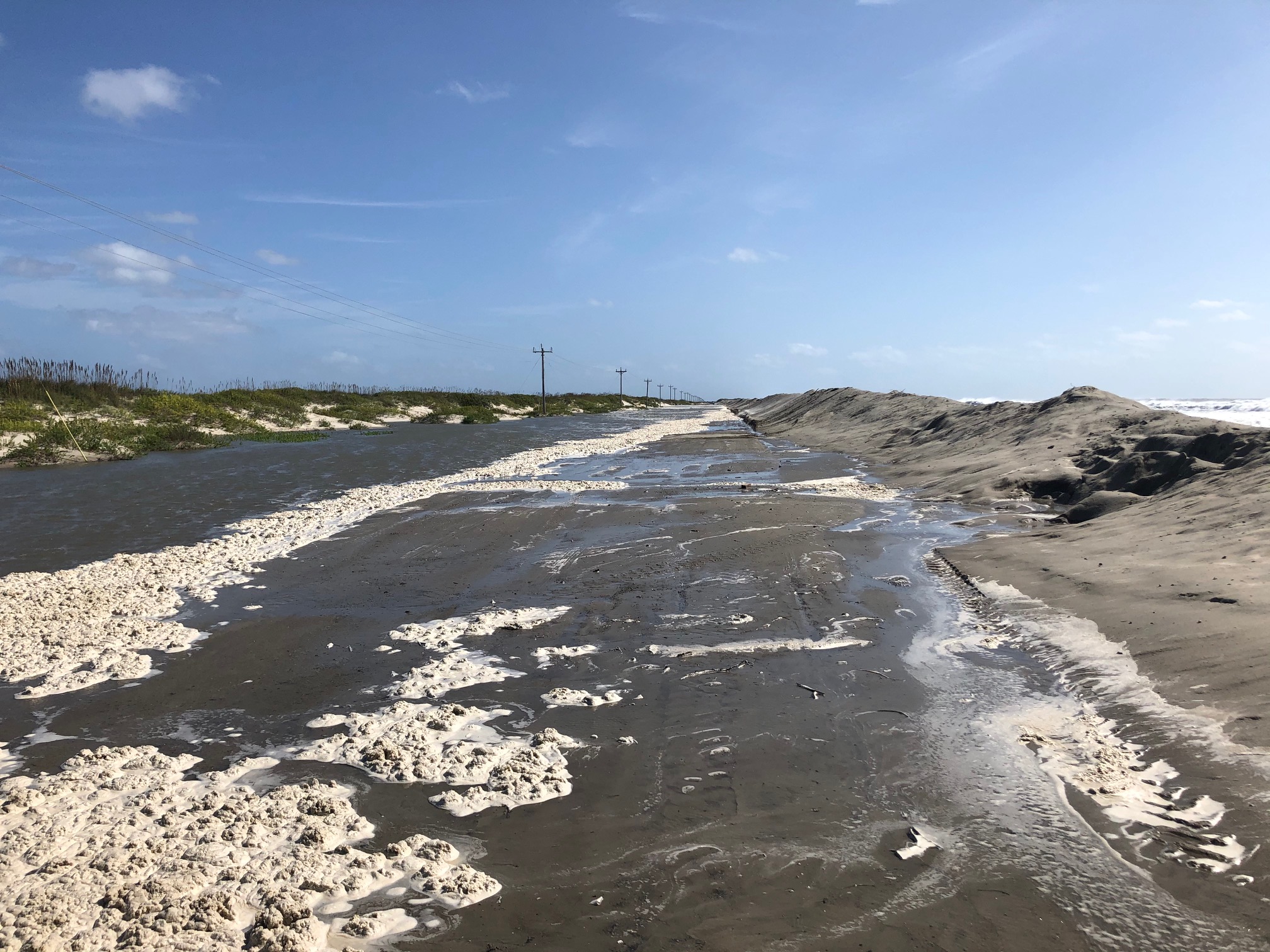
Hurricane Teddy swirling out in the Atlantic has already brought ocean overwash and left deep sand covering several sections of N.C. 12, interrupting travel between Ocracoke and Hatteras this past weekend, effects that continued Monday.
Supporter Spotlight
Strong, long-period swell from the distant hurricane arrived over the weekend and will continue along the North Carolina coast through midweek, with the potential for significant beach erosion and dune overwash, according to the Monday morning update from the National Weather Service’s Morehead City/Newport office.
N.C. 12, which was closed on and off to traffic over the weekend because of ocean overwash and deep sand, remains closed as of Monday morning between the Basnight Bridge and Rodanthe and on Ocracoke between the pony pens and the ferry terminal. The North Carolina Department of Transportation expects the sections to be closed until Tuesday.
“The combination of seasonal high tides, strong northeast winds, and long form waves created by Hurricane Teddy has caused ocean conditions that have broken through protective dunes and deposited large amounts of sand and salt water on the road. In some spots, the sand on the highway is 4-to-6 feet deep. However, no structural damage to the road has been observed,” according to NCDOT officials Monday afternoon.
NCDOT crews have been working since Saturday to clear the road while rebuilding dune lines when conditions permit. High tide cycles have slowed or even reversed. NCDOT has around two dozen people, along with a contingent of front-end loaders, excavators and graders working to reopen the road.
NC12 remains CLOSED between the Basnight Bridge and Rodanthe, as well as on Ocracoke between the pony pens and the ferry terminal. Water and deep sand cover several sections of roadway. At this point, we expect these portions of NC12 to remain closed through Tuesday afternoon. pic.twitter.com/Zt40fFba6C
— NCDOT NC12 (@NCDOT_NC12) September 21, 2020
Sunday night’s high tide was the most severe of the event so far, according to NCDOT. Crews began operations to clear the highway at 8 a.m. Monday, but officials expect the next two high tides will produce similar results.
Additionally, NCDOT in a social media post explained that the strong northeast winds are keeping the Pamlico Sound routes from operating, while river levels are too high at Cherry Branch and Bayview and the N.C. 12 closures have suspended service between Hatteras and Ocracoke.
Cape Hatteras National Seashore reports losing about 80 yards of dunes.
A coastal flood warning remains in effect for the Northern Outer Banks and Hatteras Island until Monday afternoon, but minor coastal flooding will continue for Tuesday’s high tides, according to the National Weather service. The coastal flood advisory has been extended for Pamlico, Southern Craven, Carteret and coastal Onslow counties as well as Ocracoke Island and Core Banks until Tuesday afternoon, with minor flooding forecast at high tide. The advisory for Beaufort and Tyrrell Counties expires Monday night.
A high surf advisory is extended for beaches north of Cape Lookout until Wednesday afternoon and evening. Water levels peak during the high tide cycle this morning and early afternoon.
This includes the Outer Banks north of Oregon Inlet, where impacts have been minimal so far, but the late morning high tide today will bring the greatest threat for ocean overwash and inundation of low lying roads, parking lots, and properties. https://t.co/SLch4TQMGB
— NWS Newport/Morehead (@NWSMoreheadCity) September 21, 2020
The Island Free Press reported that the following areas are especially prone to ocean overwash, and will likely be impacted over the next several high tide cycles:
- South of the Basnight Bridge to the Pea Island Visitor Center
- Mirlo Beach area, on the northern edge of the tri-villages
- South of the Avon Pier along Ocean View Drive
- At the north end of Buxton
- Between Frisco and Hatteras Village
- Along Pole Rd., south of Ramp 55 in Hatteras village
- Along the north end of Ocracoke island
The center of Teddy is forecast to move east of Bermuda Monday before transitioning to a powerful post-tropical cyclone as it moves near or over portions of Atlantic Canada late Tuesday through Thursday.
This story will be updated as needed.


