This is another in a series of reports on coastal resilience.
HAVELOCK – In the bigger picture, the most resilient communities are those that forge a connection with the water, Hunter Freeman told a crowd of nearly 300 Wednesday during the two-day North Carolina Coastal Resilience Summit.
Supporter Spotlight
Freeman, who leads sustainable stormwater management planning and implementation projects for civil and environmental engineering firm WithersRavenel, and three others were on the panel, Helping Nature Help Us: Co-Benefits of Environmental Solutions, that focused on using natural solutions.

The state Division of Coastal Management and the North Carolina Coastal Federation organized the summit held Tuesday and Wednesday in the Havelock Tourist and Event Center in response to Gov. Roy Cooper’s Executive Order 80. Cooper signed the executive order last fall directing his cabinet agencies to prepare a state climate risk assessment and resiliency plan by March 1, 2020.
The personal connection to water that Freeman sees in coastal and mountain communities is “what drives the resiliency,” he told the roomful during the summit, adding that there has to be a will to recover or a need, or both, “and where both of those exist are those areas that have that connection.”
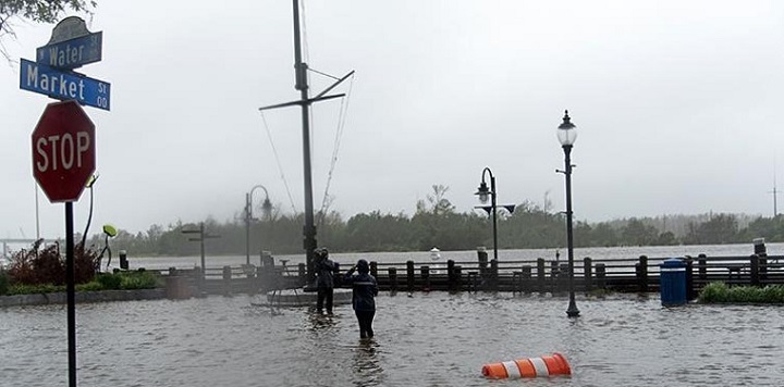
He used downtown Wilmington’s Water Street as an example and showed a photo of the flooded street that runs along the Cape Fear River.
“This is one of the most at-risk areas for flooding but yet it continually rebounds from flooding,” which he said could be because of business, tourism, development and that connection to the community driving the recovery effort.
Supporter Spotlight
Freeman emphasized that the public should be included in projects that promote natural solutions and conservation to demonstrate the value and forge that connection with water. Freeman said this can be done in a number of ways, such as designing a man-made pond as a destination that adds value to a facility, rather than simply fulfilling a permitting requirement.
“That’s the approach that most developers take … there’s almost a hesitancy to allow people to connect to water because it’s viewed as a risk instead of an asset,” he said. Sites need to be designed to treat water as the asset it is, and part of that process to connect communities with water is making the language used in design more accessible.
Forty Years of Flooding
While Freeman is looking ahead, Brian Kramer, Pine Knoll Shores town manager, is working to remediate “horrible drainage plans” that have caused flooding in the Bogue Banks town for decades.

He said that the first area that was developed in Pine Knoll Shores in the late 1950s and early 1960s, the part of town closest to Atlantic Beach, is “a stormwater and flooding nightmare.”
“It’s been going on for 40 years, and what we’ve been doing for 40 years is pumping raw stormwater coming off state highways … inundating septic fields and properties, we’ve been pumping it into the Atlantic Ocean, the Pine Knoll Shores canal and the sound. We’ve been doing that for 40 years,” Kramer said.
The town has been trying to find ways to manage stormwater for some time, but Hurricane Florence in September gave the town a sense of urgency, he said. The town has worked with the Coastal Federation on mitigation projects and trying to infiltrate stormwater where possible.
Pine Knoll Shores plans to apply next year for funding under a federal Clean Water Act program to address flooding in the eastern areas of the town. Officials have also applied to the state Clean Water Management Trust Fund to treat stormwater before it is released into the surrounding bodies of water, he said.
The town also encourages its homeowners to keep a tree canopy, rather than remove trees from the property.
“Trees help protect your house,” Kramer explained.
Kramer said that he drives through Emerald Isle to work every day and through Atlantic Beach often, noting that Pine Knoll Shores has fewer blue tarps covering damaged roofs on houses than any other town on the island. “And I believe that’s because of the tree cover,” he added.
“We have tree-density requirements. We have (homeowners) tell us what they’re going to remove and what they’re going to keep,” he said, adding that the town wants all homes to have as much tree coverage as possible. “Even the smaller homes in the older areas are tree covered and we want to keep it that way.”
Green Solutions
Burrows Smith, managing partner of the 300-acre River Bluffs residential development in Castle Hayne, used trees for a different natural solution. When he and his partners began developing the property near Wilmington, Smith said he pushed to use the state’s low-impact development guidelines issued in 2010. He decided on putting in the center of the development a park that retains stormwater and allows it to infiltrate, or soak into the ground.
 “Our infiltration basins are parks,” he said, where people utilize the 2 acres 99% of the time as a park, except for the about 1% of the time when it rains.
Smith said it’s not a typical infiltration basin because he said regulatory agencies don’t want trees in basins, but he found that the trees help improve infiltration.
Smith said he also had built a living shoreline, a more natural alternative to erosion control than bulkheads, on a part of the development’s 3,000 feet of riverbank. Although there was a bit of trial and error with the plants, he did see some success with the living shoreline once completed. The rock sill held and gained material during severe weather and, even though the plants died, Smith said it held up better than another section of the river where there was no living shoreline. There, the bulkhead built by a previous owner caved in.
Smith suggested that the regulatory agencies be more flexible to allow experimentation. He said agencies should provide resources and advice to developers and property owners on low-impact development, such as how to properly create a living shoreline.
Tools for the Public
There is support for waterfront homeowners in Carteret and Onslow counties who are looking to build a living shoreline but are unsure if the location is suitable: There’s an app for that.

Lora Eddy, coastal engagement coordinator with The Nature Conservancy in North Carolina, said the Natural Solutions Toolkit, part of the Coastal Resilience program that examines nature’s role in reducing coastal flood risk, is designed to help communities plan for coastal hazard risks and determine the best natural solutions. This includes an online Living Shorelines app for the Onslow and Carteret counties showing where conditions are best suited for a living shoreline.
“To enable communities to tap into some of our experience, we developed our Coastal Resilience program and our Coastal Resilience tools,” Eddy said.
In addition to the online toolkit and contributions of international experts, the Coastal Resilience program consists of a four-step approach: assess hazard risk and community vulnerability, identify nature-based solutions, take conservation and restoration action, and measure the effectiveness of actions to reduce flood risk.
Eddy added that the Coastal Flood and Sea Level Rise app allows for individuals to help identify areas in communities most at risk to coastal flooding from storm surge now and into the future, Eddy said. Communities can use this information to modify their floodplain management standards, for example, or start a discussion at the state level. Other tools include the Restoration Explorer to help identify the best places to build oyster reefs.


