RALEIGH — A high-powered task force of state officials and coastal legislators is preparing an economic case and legal strategy for the potential acquisition of Oregon Inlet and adjacent land in Dare County. With the land in hand, the state could then resurrect the old plan to build jetties to keep the inlet open for navigation.
The Oregon Inlet Land Acquisition Task Force, created last year by the N.C. General Assembly, is studying options for obtaining the inlet and the land on either side of it, including an outright purchase, condemnation or land swap with the federal government.
Supporter Spotlight
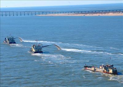
Dredges have had an increasingly tough time keeping Oregon Inlet open for navigation. Photo: Dredging News |
The inlet separates Bodie and Hatteras islands on the Outer Banks. The land on either side of it is part of Cape Hatteras National Seashore or Pea Island National Wildlife Refuge.
The 11-member task force, chaired by Secretary of Administration Bill Daughtridge, includes Department of Transportation board member Malcolm Fearing of Manteo; Department of Agriculture chief of staff Zane Hedgecock; Sens. Bill Rabon, R-Brunswick, and Bill Cook, R-Dare; and Reps. Chris Millis, R-Pender, and Paul Tine, D-Dare.
So far, the task force has met three times, once in Wanchese in Dare County and twice in Raleigh at the N.C. Department of Administration, which is now coordinating the effort. The group is working toward a May 1 deadline to submit a report to the legislature.
According to its authorizing legislation, House Bill 707, the task force is charged with “determining, reviewing, and considering the State’s options for acquiring the federal government’s right, title, and interest in Oregon Inlet and the real property adjacent thereto, including submerged lands.”
Supporter Spotlight
Subcommittees of the task force are studying the legal, transportation, environmental, economic and revenue issues. They are expected to file preliminary reports next week. The task force is expected to review a draft report at its next meeting on March 25.
The state’s renewed interest in the future of the inlet is driven by the its mercurial nature and, in part, by the latest federal water resources act, the first such legislation in six years. While the bill does not explicitly de-authorize the 40-year-old jetty project at the inlet, changes in criteria would put an end to any chance for funding it. Different versions of the bill passed Congress last year and await a conference committee to work out the differences.
At its third meeting, held last week, several task force members said it’s time for North Carolina step in to manage the inlet.

Orrin Pilkey |
Warren Judge, the chairman of the Dare County commissioners and a task force member, has long championed the jetty project. He said he thinks the group can succeed if it is able to pull together a broader economic case that includes not just fishing impacts, but water quality and flood control in the sounds and agricultural lands.
He said that overall economic effect of the inlet was ignored in the recent federal analysis, which focused on commercial fishing. At the federal level, he said, there’s no difference whether a fish is landed at Oregon Inlet or in California.
“In the scope of the federal picture it’s the same, but to us locally in Dare County and northeast North Carolina, it is very important that we keep that economic engine running,” Judge said.
Fearing, who was appointed by Gov. Pat McCrory to the DOT board last April, said keeping the waterway open was important for traditional reasons like tourism and fishing, but also for potential growth of offshore energy exploration.
“There are assets in our oceans that we’ll need to have access to,” he said.
Critics of the jetties haven’t changed their minds after all these years. The attempt to push ahead, they say, means another unnecessary battle over a fatally-flawed idea.
Orrin Pilkey, a Duke University geologist and an old jetty warrior, was one of the project’s main critics. He’s astounded that the state would consider moving ahead on its own. “I’m extremely concerned and appalled that the issue still exists,” Pilkey said. “The jetties have been thoroughly discredited on all levels.”
Formed by a hurricane in 1846, Oregon Inlet is the only access point to the ocean along the northern Outer Banks. As a notorious waterway prone to dangerous currents, the inlet has frustrated boaters, fishermen and even dredge operators with its shifting shoals and unpredictable conditions.
To stabilize the inlet, Congress in 1970 authorized the construction of two mile-long jetties. It never appropriated the money to build them, however, and the jetties became the subject of the longest-running policy debate in state history. The White House Council on Environmental Quality killed the jetty plan in 2003, but the decision included assurances that the Army Corps of Engineers would receive enough money to keep the inlet dredged to maintain the authorized 14-foot depth.
Since then, the Corps has repeatedly dredged the channel, but maintenance funding is an annual battle. A string of storms in recent years has exacerbated the shoaling, resulting in long periods where the inlet has been virtually impassable.
Plenty of headwinds

The Oregon Inlet Land Acquisition Task Force has met three times. Photo: Kirk Ross |
Even if the economic case being made wins over legislators, there are considerable cost and engineering and environmental hurdles to overcome.
At its meeting last week, the task force heard from Tom Jarrett, who as a Corps’ engineer advocated for the jetties for years. Now retired, Jarrett runs a planning and engineering firm that’s been studying a new jetty project for the Oregon Inlet Users Association in Wanchese, which represents boat builders and fishing businesses.
Jarrett told the task force that he believes a structure could be engineered that would deal with concerns raised in a 2002 assessment by U.S. Fish and Wildlife about the movement of fish larvae in and out of Pamlico Sound. He also said it may be possible to reduce costs through the use of new technologies.
But he warned that the construction of the jetties would be expensive, approaching $100 million to start and requiring up to 120 acres of land. Jarrett said jetties would be part of the overall management of the inlet and that considerable dredging and transport of sand to the beaches to the south would have to be part of the plan as well.
“The thing about the jetties, there’s still a lot sand bypassing, a lot involved with moving and managing this two to two and a half million cubic yards of sediment,” Jarrett told the task force. “Simply putting up a wall doesn’t relieve you of the responsibility of managing that sand.”
Jarrett said the new bridge to replace the Bonner Bridge across the inlet would only delay the need to have jetties and a new sand flow system in place to keep the inlet open. The new bridge would have a wider span across the navigation channel, he said, but it would only buy time.
Judge agreed. “If we don’t manage the sand, at some time in the future even the parallel bridge and its channel — the inlet span — would be in danger,” he said. “That’s something we have to consider.”

Warren Judge |
He said a proposed alternative, a 17-mile bridge on the sound side, was not a reasonable alternative. “That would never get permitted,” he said.
Another big unknown about the project is how the federal government will react should North Carolina come calling. Don Teeter of the N.C. Attorney General’s office is researching the legal issues involved in obtaining the inlet and adjacent land. He said for now there are five basic options: The state can either buy the inlet and land, persuade the federal government to give them to the state, obtain them through an act of Congress, trade land adjacent to federal land elsewhere or condemn the property under a narrowly-worded provision for transportation in the original 1958 deed that transferred land to the National Park Service for the seashore
Teeter said he would provide an assessment of the “practical likelihoods” of each option.
Speros Fleggas, an attorney with the Department of Administration, said the State Property Office was assisting with title searches and compiling maps of the properties and identifying state lands that could become part of a land swap.
“It’s not only looking at any coastal properties,” he said, “but also all the way from the mountains to the coast and identifying those tracts of state-owned land.”
Several task force members said the big unknown was how federal agencies will respond. Pea Island, to the south of the inlet, is managed by the U.S. Fish and Wildlife Service and Bodie Island, to the north, is part of the National Parks Service.
Tine said it would be good to know sooner than later what the Department of the Interior and the Corps of Engineers think of the idea. “We can sit here and plot and plan all we want to,” Tine said. “At some point we have to approach the federal government and say ‘hey, are you interested in doing this?’”
Teeter said the plans for the project need to be a little more fleshed out before federal agencies can be approached.
“Any federal office we approach about buying land or swapping land, the very first question is to be ‘how much land?’ And so we’re going to need to know what design we’re working with, what kind of land we need and where it is exactly before we go at them with that.”


