Post has been updated.
The nor’easter that swept up the East Coast this past weekend stripped ocean beaches of sand, inundated areas with floodwaters and pushed seawater over dunes and roads along North Carolina’s coast.
Supporter Spotlight

The Outer Banks suffered much of the brunt of the powerful system that brought wind, rain and coastal flooding.
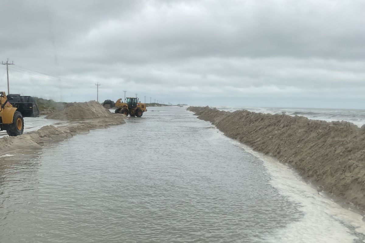
On Saturday the North Carolina Department of Transportation closed sections of N.C. 12 on Ocracoke. Overwash forced officials to close portions of the road Sunday on Hatteras Island, where crews spent the weekend pushing sand and water from the road and rebuilding the dune line that divides the beach from the road.
As of late afternoon Tuesday, N.C. 12 on Ocracoke was the only road closed and the Hatteras-Ocracoke Ferry service remained suspended, NCDOT’s Assistant Director of Communications Jamie Kritzer said in an interview.
N.C. 12 is closed on the north end of Ocracoke Island between the ferry terminal and the National Park Service Pony Pens.
“This afternoon, we’ve been forced to close N.C. 12 again on Pea Island from Marc Basnight Bridge to Rodanthe, due to ocean overwash,” Kritzer said. “The stretch on Pea Island was reopened at 5 p.m. (Monday) but the wind increased this afternoon and we saw overwash around high tide.”
Supporter Spotlight

Kritzer said that NCDOT crews were continuing to push sand and water from N.C. 12 and restore the protective dunes on both islands.
“Our ability to reopen N.C. 12 will depend on whether the dune holds through the next high tide cycle,” he said.
In addition to NCDOT’s highway crews, the state’s Ferry Division played a critical role during the response to this weekend’s nor’easter, Kritzer said.
“At one point, all seven ferry routes were suspended this weekend. However, when the winds subsided, the ferries were able to make a special run to take Ocracoke visitors back to Swan Quarter,” he said. “The Hatteras-Ocracoke ferry have helped transport highway crews and equipment between Hatteras and Ocracoke, so the crews could work on clearing N.C. 12.”
Cape Hatteras National Seashore Superintendent Dave Hallac told Coastal Review early Tuesday afternoon that there has been a lot of coastal erosion in certain areas of the national seashore.
At the time of the interview, the National Weather Service forecast much of the Outer Banks to experience flooding through Wednesday. Hallac said that he expects oceanfront flooding as a result, which could make driving on the highway through the seashore hazardous.
“The beaches continue to remain hazardous, especially the beachfront in the Buxton area and the beachfront in the Rodanthe area due to the waves and high-water levels battering many threatened oceanfront structures,” he said.
Between Sept. 30 and Oct. 2, eight unoccupied beachfront houses fell in Buxton, five of which collapsed within 45 minutes of each other. Another unoccupied house gave way on Oct. 3 in Buxton, bringing the total number of houses that have succumbed to encroaching ocean waters to 21 within the past five years.
As of Oct. 3, nine homes on Hatteras Island have toppled into the sea, “but there are a number of significantly threatened oceanfront structures, and you know, collapse is definitely possible,” Hallac said. “Even if collapse doesn’t occur, pieces and parts of those homes have broken off over the last couple of days, including large structures like decks. So that’s the reason that the entire beach front in the village of Buxton remains closed.”
He recommended travelers avoid taking N.C. 12 during the high-tide window, adding that there’s a likelihood of some minor soundside flooding as the winds are switching more to the north and northwest.
“That could also make some of our access points on the sound side flooded, and also make highway driving hazardous,” he said.
Conditions were less dire further south along the state’s coast.
Carteret County’s Public Information Officer Nick Wilson said that the county didn’t see any significant damage from last weekend’s coastal low.
“Most of the impacts were primarily in the Down East,” he said, where some roads in Cedar Island and a few other areas experienced overwash.
“A couple of our convenience sites were closed on Sunday for safety but were back to normal on Monday,” he continued. “There haven’t been any reports of building damage or injuries. The high tides over the weekend, combined with king tide conditions, did cause some flooding in low-lying spots, but it quickly receded once the low passed.”
Carteret County Shore Protection Manager Ryan Davenport said Wednesday morning that Most of Bogue Banks fared well during the recent storm.
“We did see moderate erosion and some dune escarpments in western Pine Knoll Shores, Indian Beach, and Salter Path, but the impacts were no worse than what we typically expect from a winter storm. We remain on track for the island-wide nourishment project scheduled to begin in fall 2026,” he said.
Town officials from North Topsail Beach in Onslow County to Holden Beach in Brunswick County reported experiencing some erosion and escarpment.
North Topsail Beach officials assessed the town’s little more than 11-mile stretch of ocean shoreline throughout Monday and found most erosion to have occurred along the northern end of town toward New River Inlet.
“We noticed our typical hotspots had erosion,” North Topsail’s Town Manager Alice Derian said Tuesday. “There’s some escarpment there. There was some scarping south, but the dunes are still intact.”
All of the town’s public accesses remain open.
Topsail Beach’s ocean shoreline “held up well except at the very south end,” Topsail Island Shoreline Protection Commission Chair William Snyder said.
He said that there is some escarpment to the natural dunes that front a portion of the undeveloped southern tip of the island.
New Hanover County Coastal Protection Coordinator Bryan Hall said in an email Tuesday afternoon that Wrightsville, Carolina and Kure beaches all experienced some erosion over the weekend. Wrightsville Beach’s ocean shoreline also suffered some escarpments.
“As far as I’m aware, there was no significant public or private infrastructure damage or significant established dune damage, which is a testament to the well-established dunes and the County’s Coastal Storm Risk Management (CSRM) projects,” Hall said.
Officials in Brunswick County beach towns that responded to Coastal Review’s requests for comments also reported minor erosion, including Bald Head Island and Oak Island.
“Honestly, I think we fared pretty well,” Ocean Isle Beach Town Manager Justin Whiteside said Tuesday afternoon.
One end of a privately maintained road that runs through a gated neighborhood at the eastern tip of the island has been partially eaten away.
Whiteside said roughly half of the cul-de-sac within The Pointe, a relatively new development of luxury homes, is gone.
“They’re sandbagging around the perimeter of where the cul-de-sac was,” he said.
“There have not been any reports to us of damage besides some flooding caused by tides and winds,” Holden Beach Town Manager Bryan Chadwick said in an email Tuesday afternoon. “We do feel fortunate because it could have been a lot worse.”
Storm recap
Warning Coordination Meteorologist Erik Heden with the National Weather Service office in the Newport/Morehead City office said that with this last storm, “we wanted to make sure people knew that despite it not having a name,” nor’easters can produce the same winds, flooding and rain as hurricanes.
There have been multiple offshore storms that have beaten and battered areas of the state’s coastline, particularly the Outer Banks, where N.C. 12 on Ocracoke and Hatteras islands has been closed for most of the last few days and Down East Carteret County has experienced high-water levels.
There was also a king tide, which means at certain times of the year the tides come in higher and go out lower than normal, that began early last week, leading to some flooding, which was not storm related, in Beaufort, Buxton and other spots on the Outer Banks, Heden said.
The combination of higher water levels with a king tide, a storm with gale-force winds, large waves and swells, and 3 to 4 inches of rain made everything worse, especially in low lying areas, he said.
Flooding occurred up the Neuse and the Pamlico rivers, pushing water levels in New Bern to their highest since Hurricane Ophelia in 2023.
Down East Carteret County had a “tremendous amount of water on the roads,” but nothing they haven’t experienced before, Heden said. The Outer Banks experienced significant ocean overwash, especially at the March Basnight Bridge southward to the Pea Island Visitor Center, where the man-made dunes are built.
Heden said that while the coast will experience slow improvements and fall temperatures the remainder of this week, some areas will continue to experience issues with water, especially at high tide.
“Today’s Tuesday, and we’ve got this advisory through Thursday, so it’s not going to be worse than it was this weekend. We don’t have the wind, we don’t have the swell, but it takes a while for that water to calm down,” he said.