Precariously perched as a narrow strand protruding into the stormy Atlantic Ocean, Ocracoke Island and its vulnerable highway have been a longtime headache for coastal scientists and road engineers.
Worsening erosion, flooding and storm damage exacerbated by climate change have heightened the urgency for the year-round community: What can be done to save their beloved island?
Supporter Spotlight

Researchers met with islanders Sept. 10 at the Ocracoke Community Center to present a study that modeled what the island’s future may hold under different scenarios, from the status quo to new efforts at beach nourishment and bridging.
The bottom line is that the very road itself, along with ongoing attempts to block the ocean’s advance with dunes and stabilize the roadbed with sandbags, has instead resulted in the narrow, low landscape that is currently so under threat by natural forces.
“The heart of the challenge is that the storm events we need to protect roads and buildings from would actually otherwise provide a lifeline for barrier islands in the face of rising sea levels,” Laura Moore, professor and associate chair of research with University of North Carolina Chapel Hill, said in an interview before the meeting. “It’s an extremely difficult reality, but unfortunately, the more successful we are in preventing storm impacts, the more quickly we’re managing the barrier islands out from under us.”
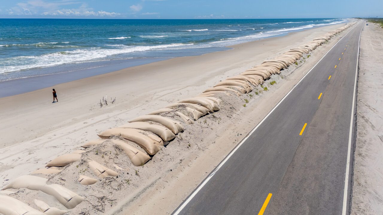
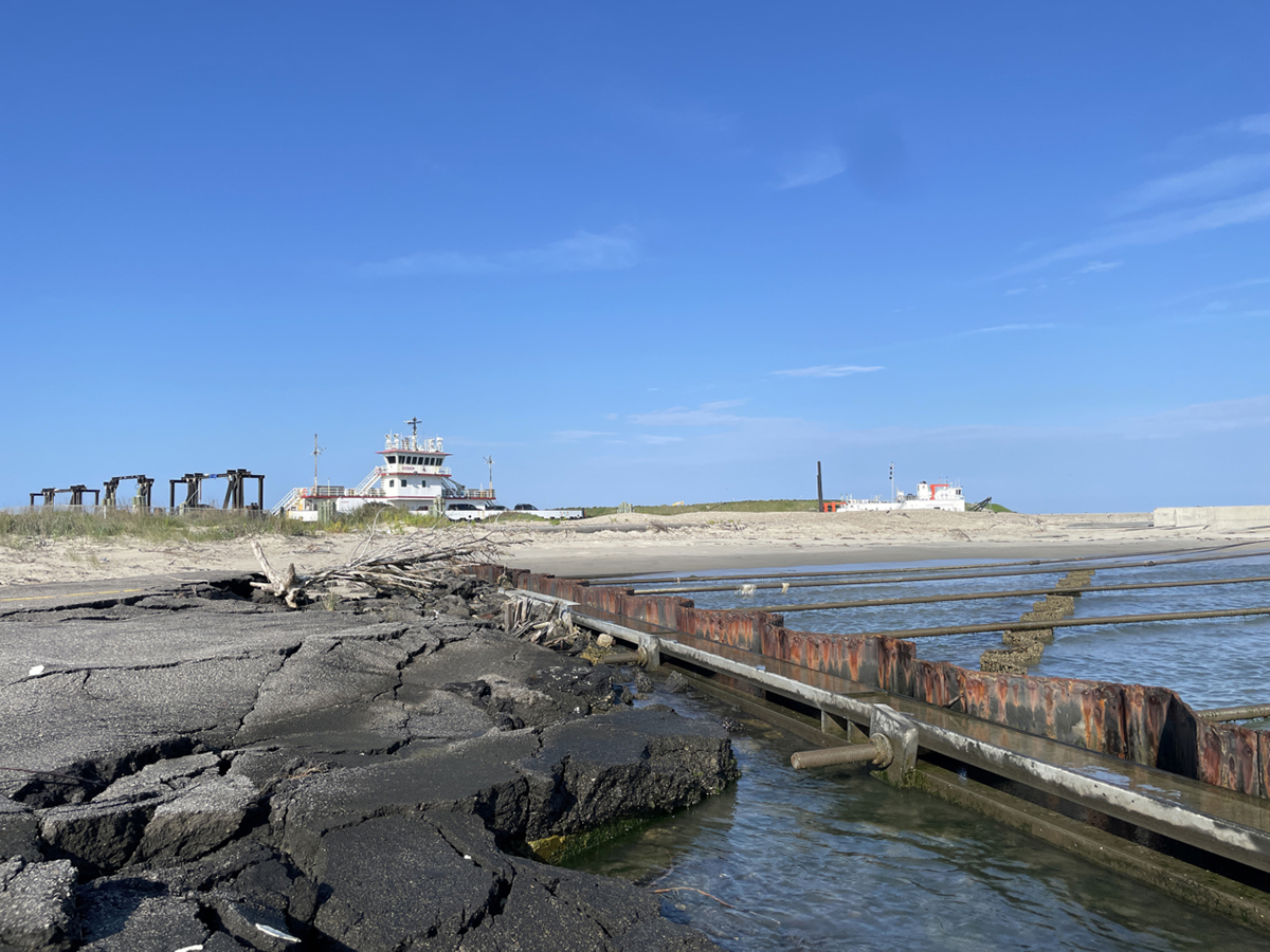
Accessible only by ferries, private boats and small planes, Ocracoke Island, most of which is part of Cape Hatteras National Seashore, depends on a single, highly vulnerable highway stretching about 13 miles from the ferry dock on the north end of the island to the village.
The road, N.C. Highway 12, has been protected by oceanside sandbags for years along one section about 5 miles from the northern ferry terminal known as the South Dock because of the link to Hatteras Island. But not only are the sand barriers unable to withstand the overwash during storms — the road was impassible and closed for several days after Hurricane Erin in August — the stacking lanes by the ferry dock have also suffered severe erosion.
Supporter Spotlight

“It’s very threatened,” Moore told Coastal Review. “I mean, we spend so much time thinking about the road, and yet (potential loss) at that terminal is a storm away, maybe two.”
The multiyear study, led by the UNC Chapel Hill researchers as part of a team that also included scientists from N.C. State University, Duke University and East Carolina University, as well as representatives from the N.C. Department of Transportation, the National Park Service, Hyde County and Tideland Electric Member Corp., is intended to provide information based on scientific modeling, and does not make recommendations or propose solutions.
“What we were charged with was to consider how different management strategies might influence the future landscape,” Moore said. “So, we have looked at different management strategies under different sea level rise scenarios, and we are able to say something about how the different strategies will likely influence Island width and island elevation and the persistence of the island in the future.”
In other words, as Moore explained, the study did not set out to design and test strategies; it instead modeled, which is essentially, “if you do ‘X’, this is what is likely to happen.”
“We’re really looking at relative differences between the management strategies in terms of their effects on the island,” she said.
Moore said that researchers studied current coastal conditions and processes and worked off data and prior research provided in the N.C. 12 Task Force report and NCDOT feasibility studies for guidance as the team developed the strategies to be reviewed: the status quo, i.e., dune road and/or sandbag rebuilding and maintenance; beach nourishment, i.e., widen or nourish the eroding shoreline with sand pumped from stored dredged material or offshore deposits; or road alternatives, i.e., relocate the ferry dock(s), which would eliminate the need to maintain hot spots on N.C. 12, or build a bridge or causeway to Hatteras Island.
What the modeling revealed is that under the status quo, the island would continue to narrow until, within years or decades, it would become impossible to maintain the transportation corridor. With use of beach nourishment, there would be short-term improvement for 10 to 20 years. But elevating or bridging the road would help to rebuild the landscape.
It’s the first time that the coastal scientists have been able to customize a barrier island model that includes all these processes for a particular location, Moore said, as well as conduct hindcast to calibrate that model.
“Not only are we supporting the local community and the stakeholders … we’re also supporting the scientific community and barrier island communities more broadly because what we’re learning also advances the science so that we can do even better next time,” she said.” It’s really been a beautiful next step to both be coproducing the science in a way that contributes to the local conversation and also contributes to the scientific advancements so that other communities throughout the world on barrier islands can also learn from one another.”
The Ocracoke erosion and road problem has been the target of much study by several iterations of an N.C. Task Force, a multiagency panel of coastal scientists and engineers and government officials that focused on seven vulnerable areas — the “hot spots” — all but one on Hatteras Island. The most recent group was established by the Dare County Board of Commissioners in 2021, with a report released in 2023.
Back in 1972, renowned University of Virginia coastal scientist Robert Dolan, who died in 2016 at age 87, warned in a study published in the journal Science about the consequences of development on the Outer Banks.
“Barrier dune development has been encouraged by man along the Outer Banks of North Carolina to stabilize the barrier islands,” according to the study abstract. “This modification of a delicately balanced natural system is leading to severe adjustments in both geological and ecological processes.”
Dolan, who was credited with being the first scientist to determine that the Outer Banks, rather than being anchored to coral reefs, was instead a 30-foot-deep shifting “ribbon of sand,” later elaborated, saying that the islands’ dune system “may be detrimental to the long-range stability of the barriers and may become more difficult and costly to manage than the original natural system.”
While other coastal scientists have built on Dolan’s research, including Moore, it is undeniable that the complex tension between natural forces and humanity’s need to control them where they live is becoming more difficult in places like Ocracoke.
“And so, the only reason the barrier islands exist in the first place is because of these processes that move sand from the front to the island interior,” Moore said. “That’s what formed these islands, right? And so now that things are changing more rapidly, we’re just really getting pinched in a way that we haven’t seen before.”
In simple terms, barrier islands are built higher and broader by overwash and wind carrying sand over the land. Where the ocean is battering away at the shoreline, the swath of land from the ocean to the sound side collects the sand, unless it’s blocked.
“We are understandably wanting to protect road and roads and infrastructure,” she said. “It makes perfect sense from that perspective, to build a dune to protect the road.”
As sea levels are getting higher, and storms intensify, the battering is more powerful. “And if we don’t allow the island elevation to build up, it will eventually become fragmented and drown in these areas,” Moore said. “So we’re kind of fighting a losing battle, unfortunately.”
Sea levels have been rising ever since the islands formed, she added. But it’s now rising much faster. Between the year 2000 and 2050, seas have been expected to rise 12 inches, a rate Moore called “very significant.”
“It’s so unfortunate, but if we can’t quickly slow the rate of sea level rise, we’re definitely going to have to find different ways to live at the coast,” she said. “In the case of barrier islands, if we want them to persist, we need to find a way to allow them to shift underneath us or accept that we may lose the ability to live on them at all.”
Still, with adjustments, there is hope, Moore said. Citing the 2.4-mile Rodanthe “jug handle” Bridge” and, farther north, the 2,350-foot-long Richard Etheridge Bridge as examples, she said sand will rebuild the island and the shoreline when the natural processes are allowed to happen.
The main goal of the research is to provide the scientific models of several scenarios so the community can work with partners in planning their island’s future.
“It’s really an opportunity to be an incredible example and posterchild leading the way for coastal communities broadly, because they are at the forefront,” Moore said.
Naturally, islanders can see that conditions are changing, and something has to be done, said Randal Mathews, chair of the Hyde County Board of Commissioners and an Ocracoke resident. For the time being, he said, the consensus seems to be to do beach nourishment.
“Well, it’s going to buy some time, because there’s no long-term plan, and there’s no real good short-term plan.”
What could be a reasonable solution, he said, is to “harden” the area with a jetty by the South Dock Ferry Terminal.
What the island folks don’t want to do is move the ferry terminal toward the Pony Pens in the middle of the island, as has been proposed in the recent past.
“They did a survey, and it was 90% of the people don’t want to move south and don’t want to lose access from Hatteras, because they know, like after Dorian, that’s what it was like here, logistically,” he said. “We were dying.”
Mathews said he is truly grateful for Moore’s and her research team’s work, and islanders are listening. But meanwhile, Ocracoke can’t withstand repeated hits to its economy, and the ferry system and road access are major concerns. And he knows that they need political support and funding.
“You know, in the big picture, there’s a lot of moving parts that we have to address, we have to come up with these short-term solutions,” he said. “And we’ve got to go to Raleigh, and we’ve got to go begging, you know, and that that’s how it works.”