OCEAN ISLE BEACH — When the Army Corps of Engineers issued its final decision on the terminal groin project here more than eight years ago, the document conveyed a prescient warning.
A terminal groin “may increase erosion along the easternmost point of Ocean Isle Beach, down-drift of the structure.”
Supporter Spotlight

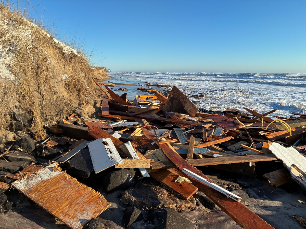
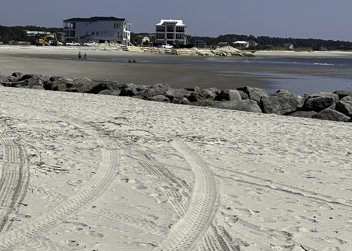
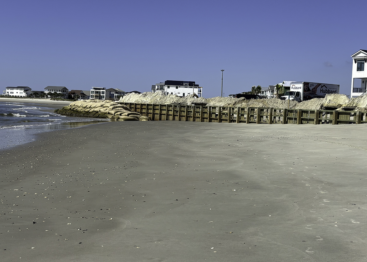
Today, the shoreline east of terminal groin is being gnawed away, vanishing beach in front of a neighborhood of grand, multimillion-dollar homes built shortly after the $11 million erosion-control structure was completed in spring 2022.
A wall of sandbags fends off waves from reaching some of the waterfront homes on the ocean side of the gated community that’s advertised as “luxurious coastal living.”
Several lots remain vacant because the properties no longer have enough beachfront necessary to meet the state’s ocean setback requirements.
“I would have never developed the property if I had known this was going to happen,” said Doc Dunlap, a developer with Pointe OIB, LLC. “It’s just devastating to tell you the truth. I even had plans myself to build there, have a summer home.”
The caveat written in the federal record of decision all those years ago, one that was a central argument in a lawsuit to try and stop the terminal groin from being built, was not explicitly pointed out to the developers of The Pointe, they say.
Supporter Spotlight

In an email responding to Coastal Review’s questions, the Division of Coastal Management said it, “is not aware of any specific notification to those property owners other than the standard (area of environmental concern) hazard notice.”
“We were just under the impression that all of this was going to be extremely positive and help protect this part of the beach,” said Jimmy Bell, who contributed to the planning and implementation of the community. “And then, once we started experiencing this massive erosion, I started researching groins more. We had engineers and other people that were helping, and we were informed and under the impression that it was going to all be good, and now it’s turning out to not be quite as good.”
Ocean Isle Beach Mayor Debbie Smith pushed back on those claims.
“My heart breaks for them, but the developers knew that that groin was going in,” she said. “They knew it was not designed to protect that area. It was not designed to harm it, but they also know that adjacent 2,000 feet west of them was a line of sandbags and most of them had been there for years.”
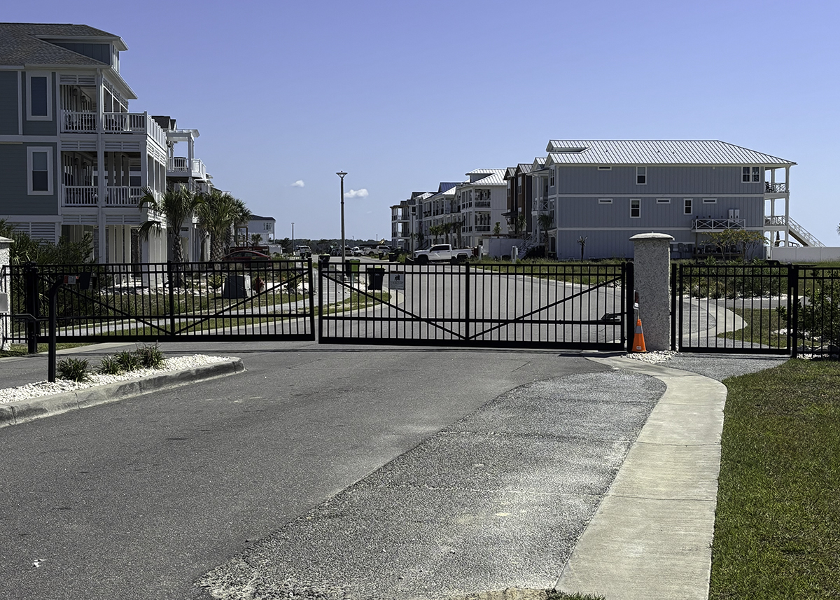
The developers are now seeking legal representation as they continue to try to figure out how to protect the oceanfront properties within the 44-lot neighborhood.
“Mr. Dunlap is extremely disappointed in the decisions made that resulted in the placement and construction of the terminal groin and the erosion damages it has caused,” John Hilton III, corporate counsel to Pointe OIB, stated in an email. “He is committed to holding those who made these decisions legally accountable and also seeking a remedy to correct the ongoing erosion. We are working to obtain local legal counsel to explore and pursue all available options.”
Erosion-battered shore
The east end of the island at Shallotte Inlet historically accreted and eroded naturally as the inlet wagged back and forth between Ocean Isle Beach and Holden Beach up until Hurricane Hazel hit in 1954.
When the powerful hurricane – likely a Category 4 storm using the Saffir-Simpson scale developed in 1971 – made landfall in October 1954 near the South Carolina border, it caused the inlet channel to move in a more easterly direction, accelerating erosion at the east end of the barrier island.
Erosion has remained persistent in that area since the 1970s, according to N.C. Division of Coastal Management records.
The worst of the erosion occurred along about a mile of oceanfront shore beginning near the inlet. An encroaching ocean claimed homes, damaged and destroyed public utilities, and prompted the N.C. Department of Transportation to abandon state-maintained streets.
In 2005, the town was permitted to install at the east a wall of sandbags to barricade private properties and infrastructure from ocean waves.
Sandbags revetments are, under state rules, to be used as a temporary measure to hold erosion at bay.
In 2011, the North Carolina General Assembly repealed a decades-old state law that prohibited permanent, hardened erosion-control structures from being built on North Carolina beaches.
Under the revised law, a handful of beach communities, including Ocean Isle Beach, get the option to pursue installing a terminal groin at an inlet area.
Terminal groins are wall-like structures built perpendicular to the shore at inlets to contain sand in areas of high erosion like the east end of Ocean Isle Beach.
These structures are controversial because they capture sand that travels down the beach near shore, depleting the sand supply to the beach immediately downdrift of the structure, stripping land that is natural habitat for, among others, sea turtles and shorebirds.
Ocean Isle Beach Sea Turtle Protection Organization Island Coordinator Deb Allen said that beach conditions east of the terminal groin have hindered turtles from nesting there this season. Escarpment, sandbags and debris that Allen believes is coming from the development have impeded turtles from accessing the sandy areas they seek to lay their eggs.
As of early September, the organization had recorded four false crawls, which is when a female turtle crawls onto a beach only to return to the ocean without laying eggs, and three nests east of the terminal groin, Allen said.
The potential for that type of impact to wildlife was argued in a lawsuit the Southern Environmental Law Center filed on behalf of the National Audubon Society in August 2017 challenging the Corps’ approval of Ocean Isle Beach’s project.
The lawsuit claimed that the Corps failed to objectively evaluate alternatives to the terminal groin, including those that would be less costly to Ocean Isle residents and less destructive to the coast, particularly to what was then the undeveloped area on the island’s east end.
The lawsuit, which later included the town, came to an end in March 2021 after a panel of appellate court judges affirmed a lower court’s decision that the Corps fairly considered the alternatives included in an environmental impact statement, or EIS, examining the proposed project.
“As we went through and talked about the impacts of terminal groins in the EIS, this was the central argument – will the land east of the groin erode at a more rapid pace? And, everything we could point to, all of the science, said yes,” said Geoff Gisler, program director of SELC’s Chapel Hill office. “There’s only so much sand and the way that these structures operate is they keep more of it in one place and necessarily take it from somewhere else. That’s why we have seen over and over again that when you build a groin towards the end of an island, what happens is the island erodes at the end. That there is less sand going to the east end is not an accident.”
‘Righting this wrong’
Gisler said the SELC will be following how the town and the Corps respond to the erosion that is occurring east of the terminal groin.
“The town committed and the Corps committed to righting this wrong if it occurred and that’s what we’ll be looking at,” he said.
Under conditions in the town’s federal permit, the town is required to monitor the sand spit east of The Pointe as well as the town’s shoreline and that of neighboring Holden Beach to the west.
Should those shorelines erode past boundaries identified in 1999, “consideration will be given to modifying the structure to allow more sediment to move from west to east past the structure,” according to final EIS.
The town also has the option to nourish an eroded shoreline.
“In the event the negative impacts of the terminal groin cannot be mitigated with beach nourishment or possible modifications to the design of the terminal groin, the terminal groin would be removed,” the EIS states.
The Corps and the Division of Coastal Management are reviewing the monitoring report submitted by the engineering firm hired by the town, Coastal Protection Engineering of North Carolina.
That report indicates that erosion “has exceeded the 1999 shoreline threshold for the area immediately east of the groin.”
“However, the applicant is working on a modification request to alter this threshold as the shoreline had eroded landward of part of that threshold prior to construction of the groin,” according to the division.
A beach maintenance project scheduled for fall 2026 to inject sand west of the terminal groin is anticipated to increase the rate of sand that bypasses the terminal groin and “would serve to ‘feed’ the shoreline immediately east of the groin with additional material,” according to the town’s engineer.
But The Pointe’s developers and property owners say they can’t wait another year.
“There’s got to be an exception to the standard application restrictions (i.e., sandbag placement and height) the (Coastal Area Management Act/Coastal Resources Commission) process has today to protect near term east of the groin due to emergency status and a path longer term that can get us to a point of evaluating what we can do for the groin from a redesign standpoint that would protect all both west and east of the groin,” property owner Brendan Flynn said. “What we’re dealing with now in my view is we need to have another review of what could be done to enhance the groin’s performance to benefit and protect the other part of this island.”
Smith said that the terminal groin is doing what it was designed to do.
“It is building up right adjacent to the groin,” she said. “It just has not built anything far enough down to protect this new development. I wish Mother Nature would reserve herself and build it up right now instead of taking it away. I wish I had some magic bullet for them too, but I don’t today. It’s really up to them to take some action.”
Kerri Allen, director of the North Carolina Coastal Federation’s southeast office in Wrightsville Beach, called the situation “heartbreaking,” but not surprising. The Coastal Federation publishes Coastal Review.
“When you alter the natural movement of sand with a hardened structure like the terminal groin, you might protect one stretch of beach, but you inevitably put other areas at greater risk,” she said. “And, unfortunately, the erosion we’re seeing east of the groin is exactly what experts warn could happen. That being said, the purpose of this groin was to protect existing infrastructure that was already at risk. Instead, new homes were built in an area that’s incredibly vulnerable and these homeowners are now facing devastating losses. Moving forward, we need to focus on solutions that don’t just shift the problem from one place to another and ensure that public resources aren’t used to subsidize these risky, short-term development decisions.”
“I think this is a pivotal moment for Ocean Isle and for other coastal towns,” she continued. “We have an opportunity to step back, look at the science, and commit to managing our coast in a way that protects both our communities and the natural systems that sustain them. That means resisting the temptation to build our way out of these challenges because, ultimately, the ocean always wins.”