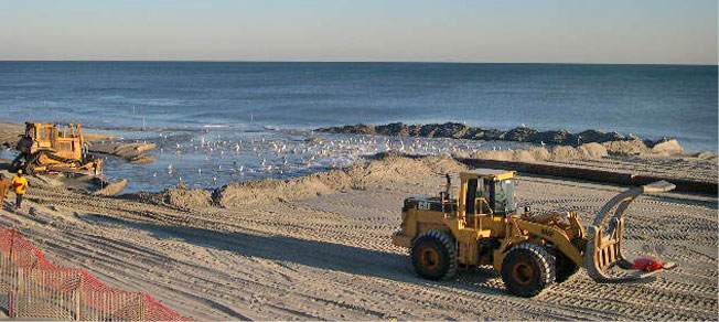
WILMINGTON — The Army Corps of Engineers’ Wilmington District announced this week that it had completed its required environmental study of Carteret County’s proposed long-term plan for re-nourishing beaches affected by erosion along Bogue Banks.
The Corps said Wednesday it had released the federal record of decision and the permit was issued for the Bogue Banks Master Beach Nourishment Plan, which is described as a comprehensive approach to protect the oceanfront and inlet shorelines. The process included the National Environmental Policy Act review, Section 404 of the Clean Water Act analysis and public interest review of the beach-management plan for the roughly 25-mile barrier island.
Supporter Spotlight
Greg Rudolph, Carteret County’s shore protection manager, said approval of the 50-year plan that was in development for about eight years was well timed as officials turn to re-nourishment needs exacerbated by Hurricane Florence in September.

“By having this we are poised to do these post-storm projects,” Rudolph said Friday, noting that after Hurricane Irene caused severe erosion to county beaches in 2011, each beach town needed separate permits and separately identified sources for sand and funding, a process that took two years. That delay won’t be necessary in future storms.
“This way we’ll have the permits in our back pockets,” he said.
Components of the plan include the use of an offshore borrow area for periodic re-nourishment along about 18 miles of beach in Pine Knoll Shores, Salter Path, Indian Beach and Emerald Isle, with potential supplemental re-nourishment along about 5 miles of the strand in Atlantic Beach, if needed. The plan also includes maintenance of the Bogue Inlet ebb tide channel within a “safe box” zone to protect the inlet shoreline of Emerald Isle. The approved plan is Carteret County’s preferred alternative of those described in the final environmental impact statement dated February.
The county’s first project under the plan was to be started this winter, and county officials were set to seek bids around the time Hurricane Florence headed toward the North Carolina coast. The targeted stretch of beach in eastern Emerald Isle and the Salter Path-Indian Beach area was to receive about 910,000 cubic yards of sand, an area that ended up losing about 955,000 cubic yards during Florence.
Supporter Spotlight
Bogue Banks beaches lost about 3.6 million cubic yards of sand during Florence, with the 18-mile stretch of beach that includes Pine Knoll Shores west to Emerald Isle losing 3.2 million of the total.
“That’s about three times what we lost in Irene,” Rudolph said, adding that a dump truck holds about 12 cubic yards of sand.
Beach re-nourishment in Carteret County is funded in part through the county’s occupancy tax on hotel and motel rooms and rentals of cottages and condos. Some municipalities also levy special property taxes to fund sand projects. The county is seeking Federal Emergency Management Agency reimbursement related to beach erosion caused by the storm.
The county Beach Commission decided in the late 2000s to create an island-wide plan for re-nourishment that looks ahead 50 years, identifies in advance all funding and sand sources and negotiates all environmental issues related to re-nourishment.
“This has been the most important thing the Beach Commission has done over the past decade,” Rudolph said.
Because the permit for the project has been issued, the Corps is not seeking comments on the decision, which is posted online.


