From an Island Free Press report

BUXTON — The early impression from a recent survey of the 2017-18 beach re-nourishment project here is that the shoreline has adapted quicker than expected to the influx of sand.
Supporter Spotlight
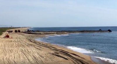
The goal of the project that began in summer 2017 was to widen a stretch of beach that extended 2.94 miles in northern Buxton. A total of 2.6 million cubic yards of sand was deposited on the shoreline from an offshore ridge 1.7 miles offshore, a site that was chosen for its sand quality and consistency with the rest of the shoreline.
The dredging was officially completed Feb. 27, right before four nor’easters pounded the Outer Banks.
Haiqing Liu Kaczkowski, senior coastal engineer for project manager Coastal Science and Engineering, which conducted the survey, estimated that the series of storms sped up the sand-distribution process.
“The early impression is that the initial volume has adapted very fast, especially during the March nor’easters,” Kaczkowski reiterated.
“The overall impression is that the project has served its original purpose, which is to protect N.C. Highway 12,” said Kaczkowski. “Since the volume (of sand) was put in place, Highway 12 has not been (impassible), even during the September hurricanes and March nor’easters. The volume has adjusted faster than it would in a normal year. Because the groins at the south end of Buxton have deteriorated and have little capacity to hold more sand, the sand loss to the south has been much higher than the historical average. The detailed reasons as to why will be evaluated.”
Supporter Spotlight

Beach re-nourishment project surveys are typically conducted immediately after they are complete to ensure that the total volume of sand deposited aligns with the original project specs. This survey had to wait until weather conditions were optimal for obtaining the most accurate results.
The survey was conducted in two parts, measuring both the width of the beach and the depth of the waters within the sandbox, or area where the sand moves within the project. The surveyors examined the land on foot with handheld equipment and the nearshore waters with a boat equipped with GPS and tools that examine the underwater topography.
Janet Morrow Dawson, owner of the Cape Hatteras Motel in Buxton, said that the goal of protecting N.C. 12 has been successful.
“Overall, we’re very satisfied,” she said.
There’s still a little more behind-the-scenes work going on before the exact results of the survey are expected to be completed by August. Contractor Weeks Marine has been working roughly 1,000 feet offshore to remove sublines that were buried and have been inaccessible until recently. All of the equipment on the beach and close to shore was removed shortly after the project’s completion.
This story is provided courtesy of the Island Free Press, a digital newspaper covering Hatteras and Ocracoke islands. Coastal Review Online is partnering with the Free Press to provide readers with more environmental and lifestyle stories of interest along our coast.


