SUNSET BEACH – A coastal developer plans to build a neighborhood on oceanfront property that was once a tidal inlet and recently removed from the state’s list of areas designated as hazardous for development.
A building plat for Sunset Beach West, a proposed 23-lot, single-family home development, was submitted to Sunset Beach planners earlier this month, a little more than two months after the N.C. Coastal Resources Commission made its controversial decision to lift the inlet-hazard area designation from the land.
Supporter Spotlight
Developing the pristine oceanfront property that stretches more than 1,600 feet between the end of Main Street and Bird Island will require a stack of local, state and federal permits and presumably buyers with deep pockets.
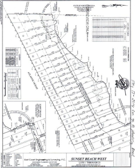 The site plan for the proposed Sunset Beach West subdivision consists of 25 acres and 23 lots that stretch from the ocean to the marsh. Source: Sunset Beach The site plan for the proposed Sunset Beach West subdivision consists of 25 acres and 23 lots that stretch from the ocean to the marsh. Source: Sunset Beach |
All of the nearly 25 acres are in a federal zone that prohibits property owners from obtaining federal flood insurance. It is also a federally designated VE, or high velocity wave action, flood zone.
Property owners in Coastal Barrier Resources Act (pronounced “cobra”) zones pay substantially higher flood insurance rates than those with federal flood insurance. They cannot take out a home mortgage without purchasing flood insurance.
The land was formerly Mad Inlet, a shallow channel that meandered between the Brunswick County town and Bird Island reserve, before drying up in the early 1990s. For years it was designated by the N.C. Division of Coastal Management as an “inlet hazard area,” vulnerable to the elements and not stable for most development.
In late February, the CRC removed the designation at the recommendation of their Science Panel on Coastal Hazards, whose experts agreed that because the land is no longer an inlet it cannot be called an inlet-hazard area. The panel also agreed that it is highly unlikely the inlet will reopen.
Supporter Spotlight
Sunset Beach’s town council opposed the CRC’s decision, arguing that the history of the inlet’s migration strongly suggests it could reopen.
The town’s planning board was initially going to review development plans at their Thursday meeting, but a question of who owns the more than 100-foot stretch of blacktop between 40th Street to where the road dead ends has halted any further assessment of the plat for now.
“This town does not show any record of us owning it,” said Sandy Wood, Sunset Beach director of Building Inspections and the administrator of the town’s Unified Development Ordinance.
The town’s attorney, officials with the N.C. Department of Transportation and attorneys for the developer are searching property records to determine ownership.
Edward Gore Sr., a well-known coastal developer and a Sunset Beach local, applied for a state driveway permit to connect a wooden bridge from his proposed development to Main Street. The 30-foot-wide private bridge would cross over marsh and wetlands to his property.
 Ed Gore Sr. wears the hat of his father Mannon Gore, who bought all of Sunset Beach, at a ceremony. Ed Gore Sr. wears the hat of his father Mannon Gore, who bought all of Sunset Beach, at a ceremony. |
It is unclear how long the bridge would be and how utilities, including water, sewer and electricity would be supplied to the homes. Utilities in a CBRA zone must be privately funded and maintained.
Gore declined to discuss the proposed development when reached at his home by telephone.
Randy Walters, town building inspector, said he is waiting for the county to determine whether Gore can tap into water and sewer lines.
Jerry Pierce, Brunswick County’s utilities director, said in an email that his staff is waiting for a response to questions sent to N.C. Department of Environment and Natural Resources concerning whether the developer can connect to county lines.
“The county did not receive any federal assistance in building the sewer mains on Sunset Beach Island,” Pierce wrote. “The water mains on Sunset Beach Island were installed by the Town of Sunset Beach and we are not sure of their funding source.”
The land is in the town’s conservation zone, which sets forth strict building rules including the stipulation that lots must be a minimum of one acre before construction.
According to the preliminary subdivision map, each proposed lot would span more than an acre from the mean high tide to the tidal marsh. The road leading from the foot of the bridge to a cul-de-sac will split each lot.
The development will require a Coastal Area Management Act major permit from the state and a CAMA minor permit, issued by the town, for each lot.
“The quickest I’m going to have this to my planning board is June the 5th and I can’t promise you it will go to them then,” Wood said.
That gives more time to island property owners like Sue Weddle, who staunchly opposed the removal of the old inlet from the hazard zone.
“The total cost of the development has to be borne on those people willing to buy in these risky, fool-hardy places,” Weddle said one recent morning as she strolled the beach toward Bird Island. “It’s just such a risk.”
Weddle and her husband have lived on the island 25 years. She was one of the leaders in the fight to preserve Bird Island more than 20 years ago. Weddle routinely walks the undeveloped stretch of beach from the western-most public beach access to the former island, which is now part of the N.C. Coastal Reserve system.
Weddle is warning other property owners that if the town is not careful in enforcing its regulations pertaining to the building rules in a conservation zone, their flood insurance could be affected.
“FEMA’s my hope,” she said. “What they can do is pull our flood insurance.”
The Federal Emergency Management Agency policy states that, if found in violation of administrating and enforcing National Flood Insurance Program rules, a community can be placed on probation for up to a year. During probation, a surcharge is added to the premium of each policy sold or renewed in the community. The surcharge is effective for at least a year after probation begins.
She and other property owners question whether the proposed development will be a successful sale to buyers in the market for beachfront property.
All 10 lots in the Palm Cove subdivision remain vacant at the easternmost tip of the island. That development, which is not in a CBRA zone, was approved more than seven years ago.

