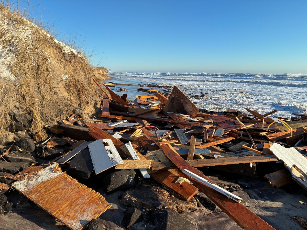
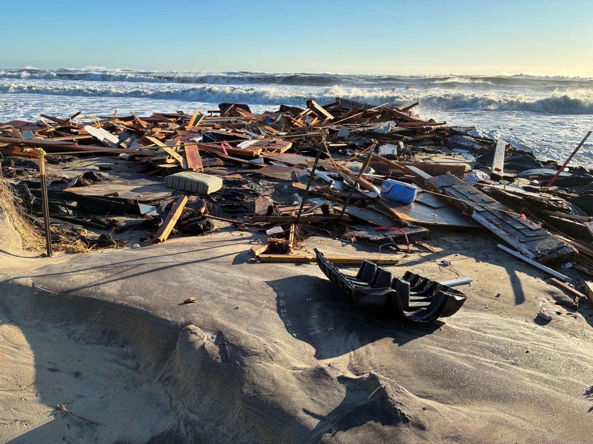
While North Carolina residents are dealing with the inches of snowfall in the aftermath of this weekend’s winter storm, National Park Service officials on the Outer Banks are also dealing with the debris left behind by four more houses collapsing on Cape Hatteras National Seashore’s beaches.
National Park Service Public Affairs Specialist Mike Barber told Coastal Review Monday that Cape Hatteras National Seashore officials were notified that a house in Buxton collapsed earlier in the day, around 9 a.m. It was the fourth unoccupied house to collapse since Sunday morning.
Supporter Spotlight

The first house at 46201 Tower Circle Road collapsed early Sunday morning. Overnight, two more unoccupied houses at 46215 and 46219 Tower Circle Road fell, then the fourth house, which was at 46285 Old Lighthouse Road, Buxton. These four bring to 31 the total number of houses to collapse on the seashore’s beaches since 2020.
“Cape Hatteras National Seashore advises everyone to stay away from the collapse sites and the surrounding beach area, due to potentially hazardous debris. The beach is closed in front of the entire village of Buxton,” Barber said.
The Outer Banks, like much of the coast, continued to experience compromised roadways Monday and people were advised to stay off the roads unless necessary.
State transportation officials closed N.C. Highway 12 Sunday evening between the Basnight Bridge and Rodanthe, as well as on the north end of Ocracoke. They said Monday that the road would remain closed, “as we continue to see ocean overwash from this weekend’s nor’easter. Overwash also occurring at Buxton corner and on Rodanthe secondaries. Crews will be out working to clear today.”
N.C. 12 experienced ocean overwash and dune breaches on Pea Island Sunday morning, as well in Buxton and in Hatteras.
Supporter Spotlight

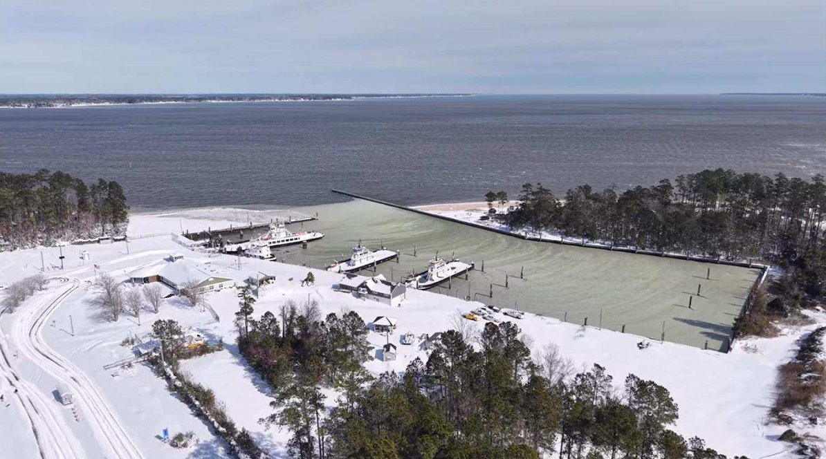
Additionally, all ferry routes were suspended Friday and remain suspended until conditions are deemed safe for operation, according to the North Carolina Department of Transportation.
NCDOT crews said they were making progress Monday clearing interstates and highways, but dangerous icy spots may remain because temperatures remained low. Gov. Josh Stein’s office and transportation officials urged people to stay off snow- and ice-covered roads and warned people to beware of black ice, which forms when ice and snow melt and then refreeze overnight into hard-to-see slippery patches.
As of late Monday, there were 2,500 NCDOT employees and contractors working to plow snow and spread salt on the highways and secondary routes. Since the storm began affecting the coast Saturday, crews have spread more than 23,000 tons of salt and plowed thousands of miles of roads.
Stein said that the state was “working around the clock to clear roads and get people back to their daily lives as quickly and safely as possible, but because temperatures will remain low overnight, this process takes time. We ask for your patience, and if you need to be on the roads this week, I urge you to slow down, give extra distance, and use caution while traveling.”
His office reported that the sunshine Monday, with temperatures reaching the upper 30s to lower 40s, allowed for snow that fell over the weekend to melt. However, that water will likely refreeze after sunset Monday evening because temperatures are forecast to fall into the teens and 20s.
Temperatures will warm into the low to mid 40s Tuesday before a cold front approaches the region.
The National Weather Service said Monday that for parts of eastern North Carolina, a light wintry mix of snow and freezing rain was possible Wednesday night.
“Please continue to remain vigilant as we are still experiencing extremely cold temperatures across the state,” NC Emergency Management Director Will Ray said in a statement. “As a reminder, several hazards remain, such as the risk of freezing pipes in homes. There are many people in our communities that are especially vulnerable to prolonged cold temperatures, so please check on your friends, family, and neighbors.”
Currituck County Emergency Management, in a social media post around lunchtime Monday, said that NCDOT crews were actively out working on the primary roadways throughout the county.
“While some roads are improving, many side roads remain covered with snow and ice, and freezing temperatures are keeping conditions slick. As temperatures drop and the sun goes down tonight, please be alert for black ice: a thin, nearly invisible layer of ice that forms when moisture refreezes on road surfaces. Black ice is especially common on bridges, shaded areas, overpasses, and low-lying roads, and can cause vehicles to lose traction with little warning,” they warned. “If you must travel, slow down, increase your following distance, and use extra caution. If you can stay home, that remains the safest option.”
Carteret County sent out a similar message Monday.
“Some roadways still have several inches of snow coverage, and partially melted snow and ice are expected to refreeze overnight, creating dangerous travel conditions. Residents are urged to stay off the roads if possible. If travel is necessary, exercise extreme caution, as icy conditions may make driving at posted speeds extremely dangerous and cause vehicles to lose traction with little warning,” according to Carteret County government officials. “Secondary and less-traveled roads are more likely to remain untreated and pose additional risks. Remaining off the roads also allows first responders and emergency management staff to continue their work safely.
Largely because of travel concerns, most county government offices were closed Monday because of the weather, and several had announced plans to close Tuesday as well, including Beaufort, Carteret, Gates, Pamlico, Dare and Hyde counties.
Record snowfall in coastal counties
Assistant State Climatologist Corey Davis, in a blog on this weekend’s snow storm, called the accumulated snow that fell all across North Carolina, “our most widespread wintry event in more than a dozen years, and the biggest snow for some areas in several decades.”
For parts of eastern North Carolina, this was the snowstorm of a lifetime, he continued.
“More than a foot fell over the central Coastal Plain, surpassing every other wintry event so far this century. The 12.5 inches in New Bern and 15 inches in Newport made this the first foot of snow for both areas since December 1989. The highest totals in the state came along the Crystal Coast, including 19.5 inches in Peletier and 17 inches in Swansboro,” he wrote.
In Cape Carteret, near whiteout conditions were observed on Saturday, Davis continues, bordering on blizzard criteria. Beaufort reported three consecutive hours with visibility of a quarter-mile or less, wind gusts of 35 mph or greater, and heavy snow falling or blowing.
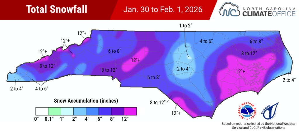
Northeast North Carolina from Friday to Sunday experienced between 6 and 10.5 inches of snow, according to the National Weather Service Wakefield, Virginia, office, which provides the forecast for the region that includes Ahoskie, Elizabeth City and Currituck County.
Mainland Hyde County experienced a widespread swath of 8 to 12 inches, with localized snowfall totals in some townships exceeding 12 to 16 inches. For Ocracoke Island, “reliable totals” range from 4 to 6 inches, and that accumulation was coupled with “significant coastal flooding and inundation,” county officials announced Monday.
Heading south, centrally located counties including Beaufort, Carteret, Craven, Dare, Pamlico, Onslow and Tyrrell saw between 2 and 19 inches. Dare experienced the least amount with 2 to 11 inches and Carteret, Craven and Pamlico had areas getting hit with more than 18 inches, according to the Weather Service office in Newport.
“Most remarkably, along the Pamlico River in Beaufort County, this was the first foot of snow in more than 67 years, since December 1958. In that region, reported totals included 17 inches in Bath, 15 inches in Bayview, and 13 inches in Belhaven,” Davis explains in the blog.
“Along with having a strong, moisture-laden low pressure system just offshore, a key factor in ramping up the snowfall amounts was the cold air that created unusually high snow-to-liquid ratios for this part of the country. While Wilmington only measured 0.32 inches of liquid precipitation, that yielded 5.8 inches of fluffy snow – the heaviest snow there since 1989 – at an impressive 18-to-1 ratio,” Davis wrote.
In a Monday morning announcement, Holden Beach officials in Brunswick County warned residents that, although the bridge to the island had reopened, roads on the island were “treacherous.”
Holden Beach’s neighboring island to the west, Ocean Isle Beach, was covered in a whopping 15 inches of snow, according to estimated totals based on National Weather Service reports and local observations.
Farther north in Brunswick County, Leland, Bolivia and Southport all received a reported 9 inches of snow.
Brunswick County announced its offices and facilities will reopen at 10 a.m. Tuesday. The Brunswick County Commissioners meeting postponed Monday had not been rescheduled as of this report.
In New Hanover County, a reported 9 inches of snow accumulated in Carolina Beach. Wilmington saw less with a little under 6 inches of snow.
And, in Pender County, Hampstead received 10 inches of snow, while farther north, areas of Onslow County got upwards from 13 inches accumulation.
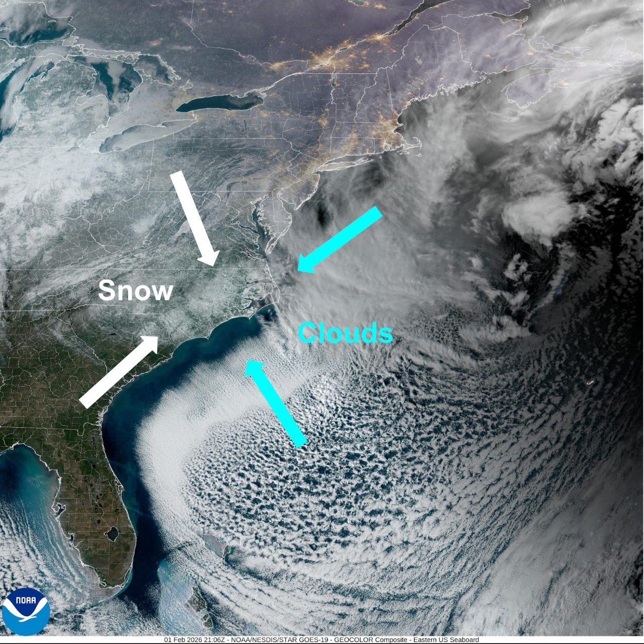
From a science perspective
Davis explained to Coastal Review that the coast was hit so hard because, “to put it simply, this was a strong nor’easter setup that happened to be cold enough for snow.”
He said that anytime the state gets these low-pressure systems right off the coast, whether they’re tropical storms or winter storms, “we know they’re capable of some major impacts. And we saw a lot of those typical impacts in this event, including the gusty winds and high surf that has already claimed a couple more houses along the Outer Banks.”
Davis compared this system and the nor’easter that moved up the coast October 2025.
The main low-pressure center started to deepen at pretty much the same location just south of Cape Fear, and the minimum pressure observed at Hatteras was nearly identical: 998.8 millibars in October, and 998.4 millibars during this storm. A millibar is a metric measurement of atmospheric pressure.
“If this had happened at any other time of year, we would have been talking about similar impacts, but with rain instead of snow. Having such cold temperatures in place so far south meant that it fell as all snow, and the snow-to-liquid ratios were off the charts compared to what we’re accustomed to. That let a lot of snow add up very quickly, and with the wind added in, that snow covered everything, and deep,” Davis continued.
When it comes to climate change and storms like these, Davis noted that a “common, or at least vocal, misconception about climate change is that it can and will make cold and snow impossible.”
He explained that while warming temperatures do make some wintry events — like the one from this previous weekend — more marginal for anything frozen, cold and snow are still a part of the winter climate, and big events like this can and do still occur.
“Of course, we’ve also seen the flip side of that, with a nearly three-year stretch with no measurable snowfall across much of the state, the average annual snowfall nearly cut in half in places like Charlotte and Raleigh, and steady warming in our wintertime low temperatures at the rate of about a degree per decade. All of those things — warming with snow events becoming rarer, along with seeing an occasional big snowfall — can still be true,” Davis explained.
“As a scientist, I think it’s important to acknowledge our certainty about climate changes and future projections. We’re very confident that the overall warming trend, especially in our nighttime low temperatures, will continue into the future, and that will continue to reduce our overall snow totals and snow event frequency. We’re less certain about how coastal winter storms like this one may change in the future,” he continued. “We often think about these climate trends as clearly pointing in one direction, but that’s really not true for projections of coastal storms like this, and there are competing forces that may affect how they evolve.”
He said that on one hand, these systems originate in tropical areas and strengthen over the warm ocean, which we know is warming at an even faster rate than the atmosphere, letting these coastal lows strengthen faster and pull in more moisture. But, on the other hand, it’s getting tougher to get temperatures cold enough over land to see all-snow events. These lows tend to bring in warm air in the mid-levels that causes precipitation to transition from snow to sleet, freezing rain, or regular rain, like we saw a couple of weekends ago.
“You might say that this storm offered up the best — or worst, depending on your perspective — of our past and future climates. We had that deep layer of cold air like we saw during our big storms back in the 1970s and 80s, but also a rapidly intensifying coastal low in a very warm and moist ocean environment that was able to drop extreme snowfall amounts,” he said. “That doesn’t mean this sort of event will get any more common in the future. It is now, and always will be, a rare collision of circumstances to bring such a major winter storm over such a large part of the state.”
Though there’s piles of snow out there, Davis said to keep in mind that, in terms of the liquid precipitation totals, most areas saw less than an inch of total liquid during this event, which he said is “a surprisingly low amount, given how much snow we received.”
That matters because it may mean the state sees less drought recovery than expected.
“Most of eastern North Carolina is still in moderate to severe drought, and even after the storm, places like Wilmington, Greenville, and Fayetteville are more than 10 inches below their normal precipitation over the past six months,” Davis said. “We may see some small improvements this week based on that precipitation, and the gradual snow melt may bring a slow recharge in streamflow and soil moisture levels over the next few weeks. But this winter is still tracking as a dry one overall, and we could use some more precipitation in any form before the end of the season to keep from entering the spring and the growing season with a bad drought still going on.”