Update 4:30 p.m. Tuesday:
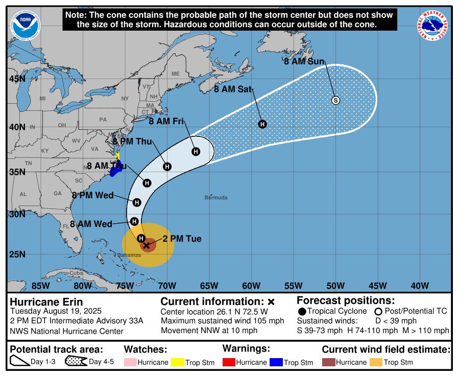
Gov. Josh Stein declared a State of Emergency Tuesday ahead of the anticipated impacts from Hurricane Erin, which was about 650 miles south-southeast of Cape Hatteras and moving at 10 mph at around 2 p.m. Tuesday.
Supporter Spotlight

“Hurricane Erin will bring threats of coastal flooding, beach erosion, and dangerous surf conditions,” Stein said in a statement. “North Carolinians along the coast should get prepared now, ensure their emergency kit is ready, and listen to local emergency guidelines and alerts in the event they need to evacuate.”
Original post 6 p.m. Monday:
Eastern North Carolina should expect to see impacts from Hurricane Erin, including coastal flooding, starting Tuesday.
The center of the storm was predicted to remain off the coast by a couple hundred miles, but “We still expect impacts across eastern North Carolina, specifically coastal areas,” National Weather Service Meteorologist Erik Heden said during a webinar briefing at lunchtime Monday.
Effects will likely include dangerous surf and rip currents, storm surge, damaging beach erosion, major coastal flooding and overwash.
Supporter Spotlight

The storm was about 820 miles south-southeast of Buxton, or 810 miles south-southeast of Morehead City, according to the National Weather Service’s 5 p.m. Monday update. The Category 4 storm was moving northwest at 10 mph.
A storm surge watch and tropical storm watch were issued for eastern Carteret County, Hatteras Island, the northern Outer Banks and Ocracoke Island.
From Duck to Cape Lookout, water levels could reach up to 4 feet above ground, and 1 to 3 feet north of Duck and south of Cape Lookout.
“Elevated water levels will likely be accompanied by large and destructive waves,” forecasters said, adding peak storm surge forecast is generally provided within 48 hours of storm surge occurring in the area.
Heden, who is with the National Weather Service’s Morehead City/Newport office, said Monday that meteorologists began watching the storm Friday, and the storm is expected to increase in size in the coming days.
Updates throughout the weekend showed that as of midday Saturday, the storm was a Category 5, which has winds at 157 mph or faster on the Saffir-Simpson hurricane wind scale. The major storm weakened to a Category 4, then to a Category 3, with winds from 111 to 129 mph, by Sunday evening.
The storm restrengthened overnight Sunday to a Category 4, with 140 mph winds, Heden said. Sustained wind speeds for Category 4 storms range from 130 to 156 miles per hour.
Forecasters said Monday that tropical storm force wind gusts were possible for the coast, with the highest probability for the Outer Banks, but stronger gusts were possible in any passing outer rainbands associated with Erin.
“The earliest reasonable time of arrival of tropical storm force winds for the immediate coastline is sometime Wednesday morning,” forecasters said. “However, the most likely time this area could see tropical storm force winds will be during the evening on Wednesday.”
The main concern with the winds will be the potential for soundside flooding on a north to northeast wind for Down East Carteret County, Ocracoke and Hatteras Island on Thursday.
Coastal flooding could begin as soon as Tuesday, more than 24 hours before any tropical storm force winds arrive, peaking Wednesday into Thursday and slowly easing up later in the week, according to the National Weather Service.
Forecasters also advise that extensive beach erosion could occur because of strong, long periods of wave energy with waves as high as 15 to more than 20 feet in the surf zone. These waves will also make the surf extremely dangerous Wednesday into Thursday, as well as the life-threatening rip currents expected the majority of this week.
Hyde, Dare counties
Hyde and Dare counties have issued states of emergency and were evacuating Ocracoke and parts of Hatteras Island ahead of the storm’s arrival Monday.
States of emergency went into effect for Dare County at 6 p.m. Sunday, and for Hyde County’s Ocracoke Island at 8 p.m. Sunday.
Dare County officials announced Sunday afternoon a mandatory evacuation had been issued for Hatteras Island Zone A, which includes all of Hatteras Island, including the unincorporated villages of Rodanthe, Waves, Salvo, Avon, Buxton, Frisco, and Hatteras.
Visitors were to evacuate by 10 a.m. Monday and residents must begin evacuating beginning at 8 a.m. Tuesday.
The mandatory evacuation order for Ocracoke visitors began at 8 p.m. Sunday and for residents starting at 6 p.m. Tuesday.
“It is extremely likely that Hyde County EMS services will not be available in Ocracoke due to Highway 12 being inaccessible. Please take this warning seriously, especially if you have medical issues or are likely to need special care,” Hyde officials said in a release, adding plans to continue monitoring the forecast and issue advisories as appropriate.
The North Carolina Department of Transportation’s ferry division announced Monday that only residents, homeowners or vendors with an Ocracoke re-entry sticker on their vehicles will be allowed on ferries inbound to Ocracoke, in coordination with the mandatory evacuation order.
“While we don’t expect Hurricane Erin to make landfall on the Outer Banks, there will likely be large waves, ocean overwash and major coastal flooding that impact Highway 12,” said Ferry Division Director Jed Dixon. “We hope everyone will heed the evacuation orders for their own safety.”
No visitors will be allowed access to Ocracoke Island until the evacuation order is lifted.
Priority boarding will be suspended for all vessels leaving Ocracoke, and tolls have been waived for ferries heading from Ocracoke to Cedar Island or Swan Quarter.
The Ocracoke-Hatteras, Ocracoke-Cedar Island and Ocracoke-Swan Quarter routes will run the published schedules until the evacuation is complete.
Service on the Ocracoke Express passenger ferry, which runs between the village of Ocracoke and Hatteras Island, is suspended until further notice.
For real-time travel information, please check NCDOT’s DriveNC.gov and the agency’s social media accounts. People can also receive text or email notifications on ferry schedules and changes through the Ferry Information Notification System, or FINS.
National Park Service
To be consistent with Dare and Hyde counties, Cape Hatteras National Seashore will be closing beach accesses and facilities, the National Park Service said.
“The Coastal Flood Watch indicates that extreme beach erosion and coastal damage is likely along the oceanside, resulting in a significant threat to life and property. Large, dangerous waves will likely inundate and destroy protective dune structures,” according to the press release. “Severe flooding will likely extend inland where there is vulnerable or no protective dune structure, flooding homes and businesses with some structural damage possible. Roads will likely be impassable under several feet of water and vehicles will likely be submerged.”
Museum of the Sea at Cape Hatteras Lighthouse and the Discovery Center on Ocracoke Island will close by 5 p.m. Monday.
Cape Point, Frisco, and Ocracoke campgrounds were to close by 3 p.m. Monday and Oregon Inlet Campground will close at noon Tuesday. Bodie Island Lighthouse will close Wednesday and Thursday.
Off-road vehicle ramps were to close by 9 p.m. Monday. To view the status of beach access ramps, visit http://go.nps.gov/beachaccess.
Due to the presence of threatened oceanfront structures, the Seashore will close beach access in Rodanthe from the terminus of Old Highway 12 to the end of the Ocean Drive and in front of the village of Buxton southward to Ramp 43.
Visitors should stay off the beaches completely and discontinue use of all beach trails and boardwalks beginning Tuesday morning.
Hurricane Erin is forecast to be a potential threat to Cape Lookout National
Seashore, with North and South Core Banks expected to experience the most significant impacts, Lookout officials said, adding that coastal flooding will likely be a long duration issue with impacts lasting late into the week.
Cape Lookout National Seashore officials plan to close facilities starting at noon Tuesday, including the Light Station Visitor Center and the Keepers Quarters Museum, through at least Friday.
Island Express Ferry Service will cease operations out of Beaufort and Harkers Island beginning Wednesday through Friday.
Great Island and Long Point Cabin Camps reservations have been canceled for Tuesday through Friday. The closure could extend beyond Friday, depending on the impact on the seashore.
“I hope Erin will remain off the coast and head out sea, but hope is not a good way forward. I really hate to impact people’s plans, and we aim to reopen as soon as possible afterwards,” acting Superintendent Katherine Cushinberry said Monday in a statement.
The National Park Service staff will be monitoring ongoing developments with Hurricane Erin and will post updates as needed on the park website at go.nps.gov/stormwatch.