State officials announced Monday the immediate temporary closure of shellfish waters. The temporary closures are due to rainfall and resultant runoff.
Division of Marine Fisheries Director Kathy B. Rawls, upon the recommendation of State Health Director Dr. Betsey Tilson, Department of Health and Human Services, announced the temporary closures.
Supporter Spotlight
It is unlawful for any person to take or attempt to take any oysters, clams or mussels or possess, sell or offer for sale any oysters, clams or mussels taken from the following polluted areas:
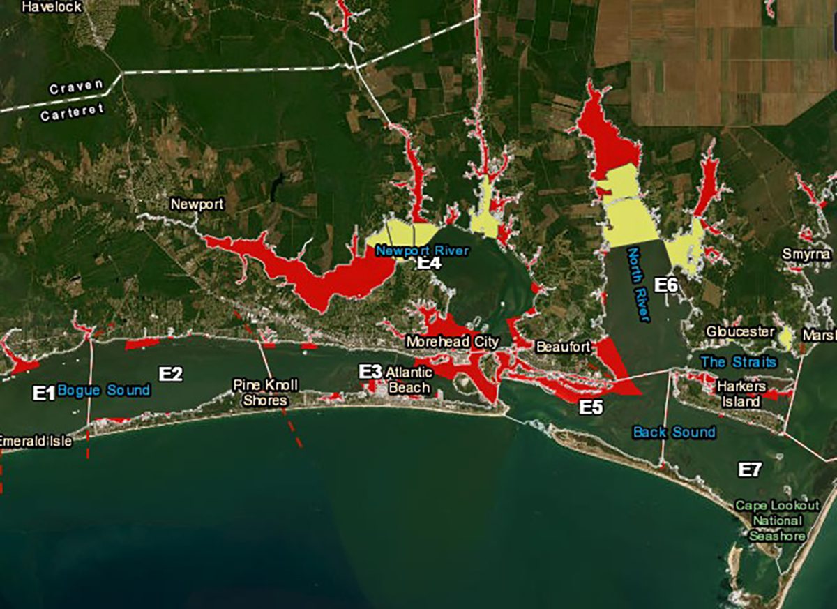
- Carteret County — All waters in Newport River upstream of a line beginning at a point 34° 45.6960′ N- 76° 43.5180′ W on the south shore near Penn Point; running northeasterly to a point 34° 46.5733′ N – 76° 42.6350′ W on the north shore near the Hardesty Farms subdivision (near the Newport River DMF Shrimp Line).
- All waters in Core Creek upstream of a line beginning at a point 34° 46.3210′ N – 76° 41.2515′ W on the west shore, running easterly near IWW Marker “25” to a point 34° 46.2251′ N – 76° 40.5919′ W on the east shore near the mouth of Ware Creek.
The following waters in Brunswick, Pender, Onslow and Carteret counties also remain closed:
- All those waters bordered on the east by a line beginning at a point 33° 54.2904’ N – 78° 23.6416’ W on the mainland near the Bricklanding Road Public Boat Ramp and IWW Beacon “84”; running southerly to a point 33° 54.1932’ N – 78° 23.6426’ W on Ocean Isle Beach near Ferry Landing Park; and bordered on the west by the South Carolina State Line, to include Tubbs Inlet.
- Shallotte River – All those waters in Shallotte River upstream of a line beginning at a point 33° 54.8302’ N – 78° 22.3626’ W near Bowen Point; running southeasterly to a point 33° 54.6139’ N – 78° 21.7667’ W on Long Point. All those waters bordered on the east by IWW Beacon “48A” (33° 55.2179’ N – 78° 14.5628’ W) and bordered on the west by a line beginning at a point 33° 54.6855’ N – 78° 21.3550’ W on the mainland; running southerly through IWW Marker “71” to a point 33° 54.4311’ N – 78° 21.2898’ W on Holden Beach near the end of Sea View Drive.
- Lockwoods Folly River – All those waters north of a line beginning at a point 33° 55.5678’ N – 78° 13.8043’ W on the south shore of Spring Creek near the mouth; running easterly to a point 33° 55.4621’N – 78° 13.1714’ W near the northern tip of Sheep Island; thence running southeasterly to a point 33° 55.2284’N – 78° 12.7791’ W near the northwest point of Horse Island, to include a portion of the Intracoastal Waterway north of Horse and Sheep Islands. All those waters bordered on the north by a line beginning at a point 34° 31.1227’ N – 77° 22.3142’ W on the mainland, running southerly near Beacon “15” to a point 34° 31.0527’ N – 77° 22.2654’ W on North Topsail Beach, near Galleon Bay; and bordered on the south by the Surf City Bridge, to include the Intracoastal Waterway, Stump Sound, Alligator Bay, and Chadwick Bay.
- Salliers Bay – All those waters in Salliers Bay upstream of a straight line across the mouth, beginning at a point 34° 33.1889’ N – 77° 18.4769’ W on the west shore; running northeasterly to a point 34° 33.3700’ N – 77° 18.1223’ W on the east shore.
- White Oak River – All those waters in White Oak River upstream of a line beginning at a point 34° 41.9497′ N -77° 06.9846′ W on the west shore; running easterly near the northern tip of Jones Island to a point 34° 41.9395′ N -77° 05.6599′ W on the east shore.
- North River – All those waters in North River upstream of a line beginning at a point on the west shore at 34° 46.0460′ N – 76° 37.0517′ W, running easterly to a point on the east shore at 34° 46.2731′ N – 76° 35.4724′ W (near the DMF Shrimp Line).
- Ward Creek – All those waters in Ward Creek upstream of a line beginning at a point on the north shore at 34° 46.2731′ N – 76° 35.4724′ W, running southerly to a point on the south shore at 34° 45.4556′ N – 76° 35.1587′ W (near the Ward Creek DMF Shrimp Line).
- Whitehurst Creek – All those waters in Whitehurst Creek upstream of a straight line across the mouth, beginning at a point 34° 43.5146′ N – 76° 33.3428′ W on the west shore; running easterly to a point 34° 43.5511′ N – 76° 33.1664′ W on the east shore.
- Sleepy Creek – All those waters in Sleepy Creek upstream of a straight line across the mouth, beginning at a point 34° 43.2745′ N – 76° 31.4600′ W on the west shore; running easterly to a point 34° 43.2672′ N – 76° 31.2792′ W on the east shore.
- Oyster Creek – All those waters in Oyster Creek upstream of a straight line across the mouth, beginning at a point 34° 48.8185′ N – 76° 26.9761′ W on the west shore; running northeasterly to a point 34° 48.9768′ N – 76° 26.6340′ W on the east shore.
Visit the Shellfish Sanitation and Recreational Water Quality website to see active shellfish closures and swimming advisories.
The Shellfish Sanitation Temporary Closure Public Viewer shows both the permanently closed shellfish harvest areas and those temporarily closed due to rainfall, stormwater runoff or other causes of short-term contamination such as wastewater spills.

