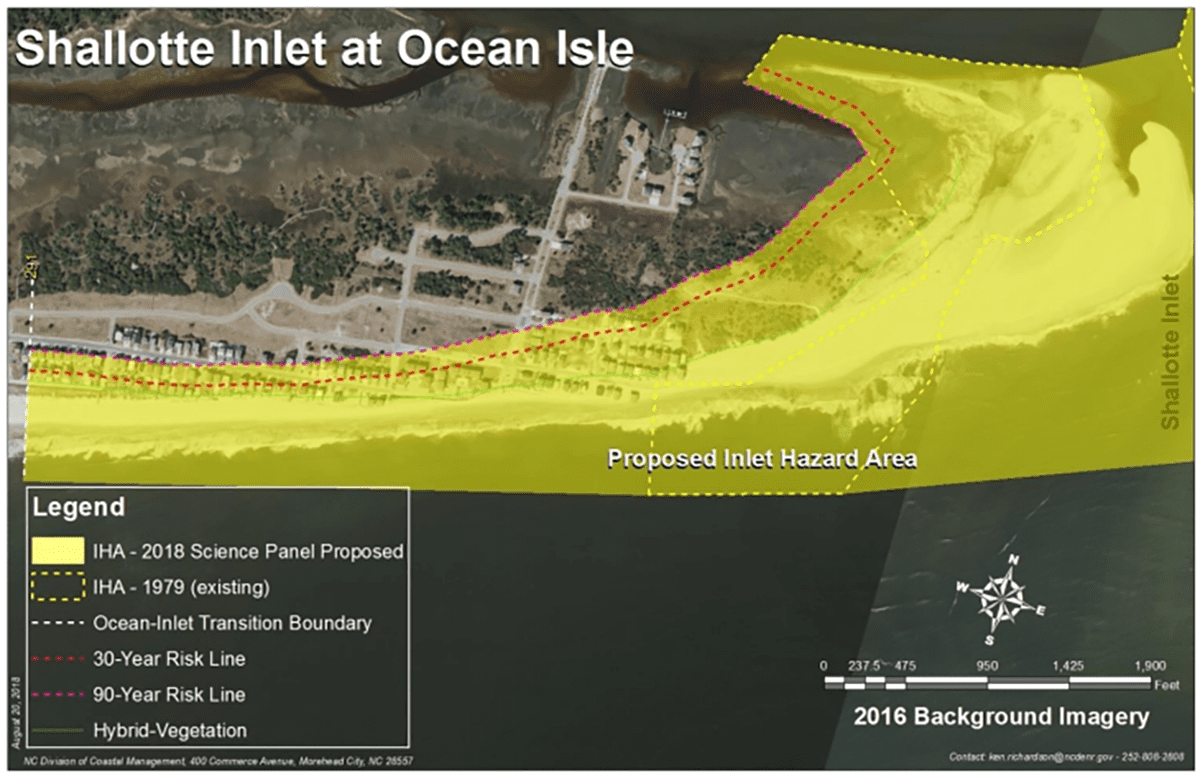
boundary with the 30-year risk line and modified 90-year risk lines. Source: Division of Coastal Management
The long-drawn process of updating maps at coastal inlets and building rules within those areas will stretch well into the New Year.
Proposed updates to the state’s inlet hazard areas, or IHAs, will be tweaked again and up for discussion at the state Coastal Resources Commission’s February 2023 meeting.
Supporter Spotlight
If the commission at that time approves rule amendments proposed by Division of Coastal Management staff, it will kick off another round of the state rulemaking process, giving everyone from property owners to developers more time to express their opinions on the matter.
Related: Coastal commission delays vote on clarified septic rules
IHAs were established at developed inlets along the state’s coast more than 40 years ago to tighten building rules in these areas where shorelines are especially vulnerable to erosion and flooding.
“So, because they’re the most dynamic places we have on the coast, that’s where we typically see our erosion hotspots, that’s where we end up with sandbags and emergency orders and long-term impacts to inland habitats and beach uses and economic impacts. Those are the most hazardous spots,” Division Director Braxton Davis said at the commission’s Nov. 17 meeting.
IHAs are designed to control density and structure size at inlets.
Supporter Spotlight
Commission members during their September meeting unanimously approved updated maps and rules for these areas, wrapping up decades of discussions on how to best predict inlet erosion and accretion rates.
But shortly after that mid-September meeting, division staff discovered that the way the new rule was written cut out an exception that would allow homes of up to 2,000 square feet to be built in areas where the new erosion rate-based setbacks in the IHAs would prevent construction of new houses.
The division later that month withdrew the updated rules from the Rules Review Commission, which reviews and approves rules adopted by state agencies.
The division hosted a series of workshops in late 2019 through early 2020 in communities that will be affected by the rule updates and extended the public comment period for the proposed amended rules.
Property owners, developers and town officials continue to raise concerns about some of the proposed amendments and the map updates.
Davis told commission members that most of the letters he had read were from property owners whose lots were in an IHA and who worried that they would not be able to rebuild their homes if destroyed or damaged more than 50% by storms, fire or other causes.
“And that is just not the way that rule reads,” he said. “In fact, all of the existing homes would be grandfathered under the rules the same way that they’re grandfathered across the entire oceanfront in North Carolina.”
However, there are restrictions to rebuilding.
“You have to have at least 60 feet of distance between the oceanfront vegetation line and where the structure is,” Davis said. “You can’t expand the footprint and so there’s some conditions.”
North Carolina has 19 active inlets. Ten of those are developed, including Tubbs, Shallotte and Lockwood Folly in Brunswick County; Carolina Beach, Masonboro, Mason and Rich in New Hanover County; New Topsail and New River in Pender County; and Bogue Inlet in Carteret County.
Hundreds of acres at those inlets are designed IHAs.
At least some Ocean Isle Beach property owners are pushing back on the proposed map for Shallotte Inlet, arguing that erosion at the island’s east end is being curtailed by the terminal groin built there last spring.
The terminal groin, a wall-like structure made of rocks placed perpendicular to the shore at inlets to reduce erosion, was built well after the proposed updated maps were recommended for the commission’s approval.
Steve Johnson lives at Ocean Isle’s east end. He was one of a handful of people who spoke during the commission’s meeting earlier this month in Beaufort about the proposed IHA rule amendments and updated maps.
“The current plan was designed in 2019,” he said. “It is 2022, three years later. We’re not talking about the current state of reality on any design, specifically Ocean Isle. Why in the world would we implement rules on something that is not current reality.”
Ocean Isle property owner Cherri Cheek agreed.
“The map created several years ago affects many homes and properties on Ocean Isle Beach,” she said. “Studies for creating these maps need to be performed in the present and take into consideration our present-day beach renourishment and the completion of the terminal groin before causing the property rights of our citizens to be in danger. The map does not change the dynamics of nature, but it does take away the property rights of our tax paying citizens. The tax repercussions to our town and our county are huge.”
Ocean Isle Beach Assistant Town Administrator Justin Whiteside said that adding another 152 acres of property in the existing IHA would exceed the $1 million impact threshold set by the state.
The state’s goal is to update the IHAs every five years.


