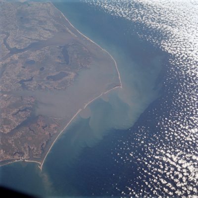
NAGS HEAD – Stark, artfully angled and shockingly skinny, the Outer Banks of North Carolina gained a whole new visual perspective of its fragile geology in a photograph taken 50 years ago by the Apollo 9 spacecraft.

The shot, taken from an altitude of about 120 miles at 10 a.m. on March 12, 1969, during the spacecraft’s 136th orbit of the Earth, was the clearest depiction of the delicate string of barrier islands and the expansive estuarine system it geographically embraces.
Supporter Spotlight
Viewed from space, the long sliver of sand is a thin golden line, curving gracefully southeast from the Virginia line into the Atlantic before making an abrupt turn at Hatteras, creating the cape’s famous, bold jut into the sea. The slender strand then turns southwest and traces the coast to Cape Lookout, where it again makes a dramatic 90-degree turn.
Back in 1969, that was a stunning – and somewhat unsettling – depiction of the Outer Banks.
“It was during an era when we were trying to tell people about the Outer Banks,” recalled Alvah Ward Jr., an 89-year-old Manteo resident who was Dare County’s first tourism director. “I think that particular view might have caused some controversy about how fragile the Outer Banks was. At that time, the Outer Banks didn’t mean much to anyone – it was eastern North Carolina. Before that, it was just pictures of fish, shipwrecks and bathing beauties.”
Apollo 9 launched on March 3 and splashed down in the Atlantic on March 13. The crew, James McDivitt, David Scott and Russell “Rusty” Schweickart, performed the first manned flight of the Apollo Lunar Module, contributing to the later success of the Apollo 11 moon landing in July. Apollo 9 is also credited with the first, two-man space walk and successful tests of life-support systems, docking and extraction.
Nearly immediately after the Apollo 9 photos were released, the image of the Outer Banks was printed on postcards and posters and has maintained its place since as one of the most ubiquitous shots of the barrier islands.
Supporter Spotlight

“It was very defining,” said J. Aaron Trotman, a veteran photographer on the Outer Banks. “This is what it is. This is where it’s at … it’s almost humbling.”
Trotman, who moved to the area in 1992, said that it would not otherwise be possible to capture such a long coastline in one photograph without stitching several views together.
“You can’t get that in one shot unless you’re up in low-Earth orbit,” he said. “That’s 200 miles of land you’re looking at.”
What makes the photograph even more extraordinary, thanks to the fortune of that morning’s clear sky, is what the discernibly different shades of green and brown on the estuarine side reveals about coastal dynamics.
“Outflow of rivers into the Atlantic shows extent of sediment discharge,” reads the caption for Figure 13-9 in NASA’s Apollo 9 mission report, which identified the photo as showing “North Carolina, Atlantic Ocean, Cape Lookout, Cape Hatteras, Pamlico and Albemarle Sounds.”
In a lecture on coastal processes and hazards given by Ken Gall at Boston College in 2015, the professor uses the image to illustrate separation of the barrier islands from the mainland by the Pamlico Sound.
“The brown color in the water is the result of sediment suspended in the water moving within the coastal system,” Gall explains in a PowerPoint slideshow presentation published online. “Notice the fan-shaped plume of sediment just seaward of Ocracoke Inlet.” The distance from Cape Lookout to Cape Hatteras is about 62 miles.
The late coastal scientist Robert Dolan of the University of Virginia studied the Apollo photograph in 1971 and found evidence of “large crescentic landforms” spanning as much as 60 miles, indicating distribution of shoreline erosion and storm overwash.
According to the mission report, “multi-spectral terrain photography” was one of Apollo 9’s experiments, using four different film and filter combinations while in orbit. A handheld camera was also used by astronauts to take photographs when time allowed.
“The photographic results were excellent, and quality and subject material exceeded that of any previous orbital mission,” according to the report, which adds that “The orbital inclination of 33 degrees late in the flight permitted vertical and near-vertical coverage of many areas never before photographed from space. Of particular interest are the Appalachian and Ouachita Mountains, the eastern coastal plain and the Piedmont Plateau.”
The mission allotted four days for photography and much attention was paid to weather conditions, sun angle and ground-track coverage, in interest of meteorological and geological sciences. Four modified Hasselblad cameras had been installed in the hatch window, and various filters and infrared, color and black-and-white film were deployed. A total of 584 frames were exposed, the report said, representing 127 complete photographic sets. About 93 frames were taken over mostly cloud-free land.
The shot of Cape Hatteras, the report said, is one of the crew’s “remarkably” large number of high-quality pictures taken with a handheld camera.

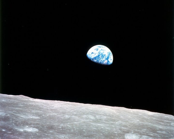
Photographs from the Apollo missions overall are credited with changing attitudes about people and their place on Earth and in the universe. The view of the Earth rising, taken in 1968 from Apollo 8, spurred increased interest in ecology and the environment, eventually leading to the founding of “Earth Day.” Four years later, the famous “Blue Marble” shot was taken from Apollo 17.
Although NASA spokespersons were unavailable to confirm it, Schweickart, who was then 33, has been reported to have taken the handheld photographs. Schweickart, who along with his two Apollo crewmembers, is still alive and active, gained a more modern fame in his telling of observations of Earth during his Apollo 9 spacewalk in a speech he gave to the nonprofit Lindisfarne Association in 1974 that has since gone viral on social media.
Schweickart, who had founded a group to track asteroids, spoke about how much he was affected by seeing Earth from space and has often since repeated that impression in many public appearances over the years. In a small way, his profound experience explains why the Apollo 9 image of the Outer Banks may be so striking
“How did I get here? Humanity has reached this point where we’re moving out from the Earth. I’m a small part of that, but that’s what’s going on. How does that happen in history?” Schweickart said. “Who am I? Am I ‘me,’ or am I ‘us?’ It’s very clear that you’re there as a representative of humankind. This is humanity moving out, and you’re just the representative on that frontier.”


