As Hurricane Florence approaches, Coastal Review Online will continue to provide updates as they are available and for as long as conditions and circumstances allow.
2 p.m. Thursday
Supporter Spotlight
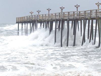
N.C. 12 is now closed south of Oregon Inlet due to ocean over-wash making the road impassible in several locations.
Here’s a look at overwash on NC12 just north of Hatteras Village. Again, this is NOT the time to be out on the roads on either Ocracoke or Hatteras Islands. pic.twitter.com/idLvXZ5Gyt
— NCDOT NC12 (@NCDOT_NC12) September 13, 2018
There was not much change with the National Hurricane Center’s latest update as heavy rain bands with tropical-storm-force winds spread across the Outer Banks and coastal southeastern North Carolina.
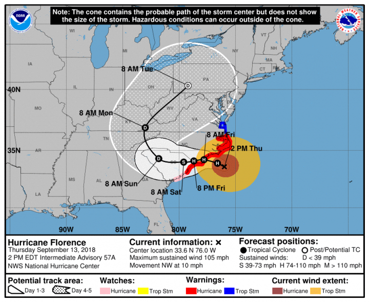
At 2 p.m., Florence was near latitude 33.6 degrees north, longitude 76.0 degrees west or about 110 miles east-southeast of Wilmington. Florence is moving toward the northwest near 10 mph. A gradual decrease in forward speed is expected through Thursday. A turn toward the west-northwest and west at an even slower forward speed is expected by Thursday night and continuing into Friday, and a slow west-southwestward motion is forecast Friday night and Saturday
Maximum sustained winds remain near 105 mph with higher gusts. Little change in strength is expected before the eye of Florence reaches the coast, with weakening expected after the center moves inland.
#NWS braving the elements of #Florence to get important upper air data. 18Z weather balloon launch. pic.twitter.com/rfLXBB8nXH
— NWS Newport/Morehead (@NWSMoreheadCity) September 13, 2018
11 a.m. Thursday
Supporter Spotlight
Hurricane Florence continued to thrash parts of the North Carolina coast Thursday morning with bands of showers and strong gusts.
At 11 a.m., Florence was near latitude 33.4 degrees north, longitude 75.5 degrees west or about 145 miles east-southeast of Wilmington. Florence is moving toward the northwest near 10 mph. This general motion, accompanied by a further decrease in forward speed, is expected to continue through Thursday. A turn to the west-northwest and west at an even slower forward speed is expected tonight and Friday, and a slow west-southwestward motion is forecast Friday night and Saturday. Data from the aircraft and Doppler weather radars indicate that maximum sustained winds had decreased to about 105 mph.
Florence was approaching the Gulf Stream current and the hurricane is forecast to move over warmer and deeper waters in six to 12 hours, which could allow for some slight strengthening. Just prior to landfall in about 24 hours, Florence is expected to weaken some due to upwelling of the shallow coastal waters. After landfall occurs, rapid weaning of the stronger inner-core wind field is expected to due land interaction and Florence’s slow forward speed of 5 kt or less. However, intense rain bands are expected to develop over the Atlantic waters and keep moving along the coast and inland, likely producing strong wind gusts through Saturday night.
As expected, conditions are worsening on highway 12 in the usual spots. This is a picture of the S-Curves north of Rodanthe this morning, with high tide still a few hours away. While the road is still “passable” right now, travel is not advised. pic.twitter.com/ZS6GNVWWr9
— NCDOT NC12 (@NCDOT_NC12) September 13, 2018
Storm surge has begun to overwash the dunes during the last hour on the incoming tide. Sending well wishes to that brave operator working to hold the line. #Florence #NC12 #OBX pic.twitter.com/BvA1k4FfAQ
— Michael Flynn (@RippleEnviro) September 13, 2018
8 a.m. Thursday
Hurricane Florence’s outer rain bands began arriving along portions of the North Carolina Thursday morning amid little change in the forecast from the previous update.
The National Hurricane Center in its 8 a.m. advisory said satellite views of Florence changed little overnight, with the eye waxing and waning in infrared imagery. The eye had moved into National Weather Service radar range and can be seen in radar data from Morehead City and Wilmington weather offices.
Sun rising over Hurricane #Florence as it moves closer to the coastline pic.twitter.com/xniqHQn2s1
— NWS Columbia (@NWSColumbia) September 13, 2018
The eyewall was open to the southeast, indicating that the intensity may be slightly lower, but the data may not account for the storm’s strongest winds. Another Air Force hurricane hunter plane was on the way to get a better assessment of the intensity of the hurricane. Southern shear has affected the inner core, but models suggest that this shear will relax Thursday as Florence moves over warm waters, but little overall change in strength is anticipated as Florence approaches the coast.
Maximum sustained winds are near 110 mph with higher gusts. Florence is a large hurricane with hurricane-force winds extending outward up to 80 miles from the center and tropical-storm-force winds outward up to 195 miles.
Gradual weakening should occur as the hurricane interacts with land, more quickly as Florence moves farther inland.
More Shelter Space Available
Marine Corps Air Station Cherry Point has two storm shelters for active-duty and retired military personnel, their families and for civilian government employees who normally would have access to the air station. The shelters opened at 4 p.m. Tuesday and still have room for authorized personnel. The Marine Dome shelter is a pet-friendly shelter but pet owners must remain in the shelter with their pets and provide kennel, food, water and bowls for the pets. Pets must be on a leash or in a kennel at all times, and vaccination records are
required.
The other shelter is located at the Cherry Tree House, which does not allow pets.
Locations and parking information is available on the www.cherrypoint.usmc.mil.
12:01 a.m. Thursday
State officials once again appealed to coastal residents hoping to ride out Hurricane Florence to head inland now before life-threatening storm surge and what could be record rainfall makes escape impossible.
By the end of the day Wednesday, Florence appeared to be diminishing in strength, but don’t be fooled by any weakening, forecasters warned.

The storm’s maximum sustained winds had decreased at 11 p.m. Wednesday to near 110 mph with higher gusts, making Florence a Category 2 storm. Little change in strength was expected before the center reaches the coast, with weakening expected after the center moves inland.
Meanwhile, coastal residents were busy Wednesday securing their homes, boats and businesses and getting out.
In Beaufort, waterfront district businesses were boarded up, some with sandbags in doorways to slow rising waters. Many stores and restaurants in Morehead City were closed or closing early Wednesday afternoon.
Morehead City Mayor Jerry Jones on Wednesday declared a curfew beginning at 10 a.m. Thursday.
In Beaufort County, Belhaven has enacted a curfew from 10 p.m.-5 a.m.
The Hyde County Board of Commissioners issued a countywide curfew effective 9 p.m, Thursday. The curfew will be in effect daily, from 9 p.m. to 5 a.m. until further notice.
In Dare County, access into the county will be restricted to those with a Priority One Critical Personnel Pass issued by Dare County Emergency Management or a Critical Needs Pass issued by Currituck County Emergency Management after 8:30 a.m. Thursday.
In a briefing in Raleigh late Wednesday afternoon Gov. Roy Cooper said state and local officials were continuing to urge people to evacuate.
“We know a lot of our coastal residents have ridden out storms before,” Cooper said. “This should not be one of those storms. Don’t risk your life ridding out a monster.”
Cooper ordered Tuesday a mandatory evacuation of the state’s barrier islands to give extra emphasis to the local evacuation orders already in place.
Governor Cooper in Kinston today: “We want to continue to send the message that this monster of a storm is not one to ride out.” pic.twitter.com/osAmqC0lIC
— Governor Roy Cooper (@NC_Governor) September 12, 2018
The governor said state and local officials would try to determine how many individuals have opted to remain on Ocracoke and Hatteras islands despite the orders to evacuate.
Coordinates, Forecast
At 11 p.m. Wednesday, Hurricane Florence was the center of Hurricane Florence was near latitude 32.0 degrees north, longitude 73.7 degrees west, or about 280 miles east-southeast of Wilmington, and was moving toward the northwest at about 17 mph. This general motion, accompanied by a gradual decrease in forward speed, was expected to continue through Thursday. A turn to the west-northwest and west at an even slower forward speed was expected Thursday night and Friday, and a slow west-southwestward motion is forecast Friday night and Saturday.

The center of Florence will approach the coasts of North and South Carolina Thursday, then move near or over the coast of southern North Carolina and eastern South Carolina in the hurricane warning area on Thursday night and Friday. A slow motion over eastern South Carolina is forecast Friday night and Saturday.
The National Hurricane Center said reports from an Air Force Reserve Hurricane Hunter aircraft indicate that hurricane-force winds extend outward up to 80 miles from the center and tropical-storm-force winds extend outward up to 195 miles.
Forecasters said the combination of a dangerous storm surge and the tide will cause normally dry areas near the coast to be flooded by rising waters moving inland from the shoreline. The water has the potential to reach the following heights above ground if peak surge occurs at the time of high tide:
- 9-13 feet from Cape Fear to Cape Lookout, including the Neuse, Pamlico, Pungo and Bay rivers.
- 6-9 feet from North Myrtle Beach, South Carolina to Cape Fear.
- 6-9 feet from Cape Lookout to Ocracoke Inlet NC.
- 4-6 feet from Ocracoke Inlet to Salvo.
- 2-4 feet from Salvo to the North Carolina/Virginia Border.
The deepest water will occur along the immediate coast in areas of onshore winds, where the surge will be accompanied by large and destructive waves. Surge-related flooding can vary greatly over short distances.
Storm surge predictions in graphical, GIS-mapped form are available via the ADCIRC system of computer programs. Co-developed by Rick Luettich, director of the University of North Carolina Institute of Marine Sciences in Morehead City, the system has been in development for years and used by the Army Corps of Engineers and other federal agencies.
The National Weather Service is warning residents not to be fooled by the storm’s decreased maximum winds. “This ‘weakening’ only refers to maximum winds,” the service announced on Twitter. “The wind field has expanded and rainfall/storm surge potential are still at catastrophic levels.”
Maximum winds from #Florence have decreased, but don’t let that fool you. This “weakening” only refers to maximum winds. The wind field has expanded and rainfall/storm surge potential are still at catastrophic levels.https://t.co/meemB5uHAR pic.twitter.com/IRiuxeVeUf
— NWS (@NWS) September 13, 2018
Florence is expected to produce heavy and excessive rainfall, as much as 20-30 inches on the North Carolina coast, with isolated areas getting as much as 40 inches. This rainfall could produce catastrophic flash flooding and significant river flooding, forecaster said.
Ferry service to Ocracoke Island was suspended late Wednesday and vessels were moved to their safe mooring locations after about 2,000 residents and visitors were evacuated from the island.
The time has come to get our ferries to safe harbor and hunker down for the storm. As of 6pm tonight, all seven of our routes have suspended service until the threat from Hurricane Florence passes. Stay safe out there, everyone, and we’ll see you when conditions improve! pic.twitter.com/cUiKujfp52
— NCDOT Ferry Division (@NCDOT_Ferry) September 12, 2018
Kirk Ross contributed to this report.
Scroll down for previous reports.
6 p.m. Wednesday
Storm surge is becoming a focus of concern as Hurricane Florence moves toward the Carolinas where forecasters say the now-Category 3 storm could stall for a day or so.
Aircraft reconnaissance, satellite images and intensity estimates indicate that Hurricane Florence weakened during the day Wednesday but inner-core and outer wind fields continued to expand, the National Hurricane Center said in its 5 p.m. update. The result is in an increase the cyclone’s total energy, which forecasters say will create a significant storm surge event.
An analysis by Rob Young, director of the Program for the Study of Developed Shorelines at Western Carolina University, says the forecast showing the storm slowing down just offshore of Wrightsville Beach and moving very little for a 24-hour period could spread Florence’s extremely high storm surge over multiple tidal cycles. That means significant coastal erosion, substantial loss of sand dunes, barrier island over-wash and major infrastructure damage along the immediate coast, according to Young’s analysis.
The biggest effects could be seen from Bald Head Island north to Emerald Isle, with the highest surges between Kure Beach and North Topsail Beach.
Young notes that the forecast track had changed dramatically during the previous 24 hours after remaining fairly consistent for nearly three days. “It will be interesting to see if it continues to change,” Young notes. “The forecast cone has greatly expanded. The timing of the storm’s slow down and the predicted turn to the west should be closely monitored.”
If the storm makes landfall near Myrtle Beach, South Carolina, the highest storm surge is still likely to remain north of Cape Fear, according to Young.
At 5 p.m. Wednesday, the center of Hurricane Florence was near latitude 30.9 degrees north, longitude 72.5 degrees west. Florence was moving toward the northwest at about 16 mph. The storm’s forward speed is expected to slow gradually through Saturday. The center of Florence will move over the southwestern Atlantic Ocean between Bermuda and the Bahamas Wednesday night, approach the coast of North Carolina or South Carolina Thursday and Friday and move slowly near the coastline through Saturday.
Maximum sustained winds had decreased to near 120 mph with higher gusts.
11 a.m. Wednesday
Hurricane Florence is maintaining maximum sustained winds near 130 mph with higher gusts.
The National Hurricane Center said an Air Force Reserve reconnaissance aircraft indicate that the center of the eye of Hurricane Florence was near latitude 29.8 degrees north, longitude 71.3 degrees west or about 485 miles southeast of Wilmington. Florence is now moving toward the northwest near 15 mph. A gradual decrease in forward speed is expected through Saturday.
Florence remains a Category 4 hurricane but some strengthening is forecast through Wednesday night. While some weakening is expected to begin by late Thursday, Florence is still forecast to be an extremely dangerous major hurricane when it nears the U.S. coast Friday.
Hurricane-force winds extend outward up to 70 miles from the center and tropical-storm-force winds extend outward up to 175 miles.
Carteret County officials announced they will open a shelter at 5 p.m. at Newport Middle School.
For those evacuating, check the Department of Public Safety list of shelters statewide.
A look at the #sunrise over #Florence this Wednesday morning, still churning WNW toward the #NCwx coastline. Some track changes (further south) but many inland impacts remain the same. Get the latest info: https://t.co/2SQKH6G0vB pic.twitter.com/jfThoDwR27
— NWS Raleigh (@NWSRaleigh) September 12, 2018
9 a.m. Wednesday
Florence remained a Category 4 hurricane Wednesday morning, as its forecast track moves slightly south toward Cape Fear.
Forecasters warn of rising waters from storm surge and inland flooding as a major threat, in addition to powerful winds and heavy rain. The combination of a dangerous storm surge and the tide will cause normally dry areas near the coast to be flooded by rising waters moving inland from the shoreline, according to the National Hurricane Center in Miami.
At 8 a.m. Wednesday, forecasters said the eye of Hurricane Florence was near latitude 29.4 degrees north, longitude 70.7 degrees west. Florence is moving toward the west-northwest at about 17 mph, and this motion was expected to continue Wednesday morning. A motion toward the northwest is forecast to begin by the afternoon and continue through Thursday.
Florence is expected to slow down considerably by late Thursday into Friday and move slowly through early Saturday.
Maximum sustained winds were near 130 mph with higher gusts. The storm should strengthen through Wednesday night, with some weakening expected Thursday. Hurricane-force winds extend outward up to 70 miles from the center and tropical-storm-force winds extend outward up to 175 miles.
5 p.m. Tuesday
A hurricane warning and a storm surge warning are now in effect from South Santee River, South Carolina, to Duck and the Albemarle and Pamlico sounds, including the Neuse and Pamlico rivers.
The National Hurricane Center included the new warnings in its 5 p.m. update on Hurricane Florence, a strengthening Category 4 storm on the Saffir-Simpson Wind Scale. Also, a tropical storm Watch has been issued from north of the North Carolina-Virginia border to Cape Charles Light, Virginia, and for the Chesapeake Bay south of New Point Comfort.
A hurricane warning means that hurricane conditions are expected somewhere within the warning area. A warning is typically issued 36 hours before the anticipated first occurrence of tropical-storm-force winds, conditions that make outside preparations difficult or dangerous. Preparations to protect life and property should be rushed to completion, the National Hurricane Center said.
A storm surge warning means there is a danger of life-threatening flooding moving inland from the coastline during the next 36 hours.
At 5 p.m. Tuesday, the center of the eye of Hurricane Florence was located by satellite near latitude 27.5 degrees north, longitude 67.1 degrees west. Florence was moving toward the west-northwest at about 17 mph. Florence is expected to slow down considerably by late Thursday into Friday as the storm approaches the coast of North Carolina or South Carolina in the hurricane warning area on Thursday and Friday.
Maximum sustained winds had increased to about 140 mph with higher gusts. Further strengthening is forecast Tuesday night and Wednesday. While some weakening is expected on Thursday, Florence is forecast to be an extremely dangerous major hurricane through landfall. Hurricane-force winds extend outward up to 60 miles from the center and tropical-storm-force winds extend outward up to 175 miles.
Governor Mandates Evacuation
Backing up local orders already issued in coastal communities, Gov. Roy Cooper issued Tuesday a mandatory state evacuation order for vulnerable coastal areas.
The state evacuation order applies to North Carolina’s barrier islands.
The governor’s office said the entire state should brace for Florence’s effects, and people asked to evacuate should get out now.
“The waves and wind in this storm may be like nothing you have ever seen,” Cooper said. “Even if you’ve ridden out storms before, this one is different. Don’t bet your life on riding out this monster.”
For current evacuation information, visit the state Department of Public Safety’s Hurricane Florence website.
On Monday, President Trump granted Cooper’s request for a federal disaster declaration for North Carolina, a move to expedite federal aid to the state and its residents. The action also sets up Federal Emergency Management Agency and military preparation and response in the state.
Cooper’s office warns that residents should be prepared to lose power for several days or weeks.
“We can’t expect this storm to blow over in a matter of hours. Remember you need to have enough supplies for several days,” Cooper said.
North Carolina Emergency Management activated the state Emergency Operations Center to work with the counties, FEMA and partners in the state Emergency Response Team that includes all state agencies, utility and private sector representatives and volunteer agencies active during disasters.
The North Carolina Disaster Relief Fund is accepting contributions for Hurricane Florence damage. Contributions are to be distributed by the United Way of North Carolina directly to Hurricane Florence victims. Contributions may be made online or by mail at North Carolina Disaster Relief Fund, 20312 Mail Service Center, Raleigh, NC 27699.
Community Response
- Jacksonville Mayor Sammy Phillips, noting that storm surge is expected to be higher than ever experienced there on Tuesday urged city residents to evacuate in advance of the storm. The mayor said a curfew would be called as the storm approaches.
- Carteret County government offices will close at noon Wednesday.
2 p.m. Tuesday
Florence is getting better organized and increasing in size according to the National Weather Service National Hurricane Center.
The 2 p.m. update states that life-threatening storm surge is possible along the coasts of North and South Carolina with inland flooding to follow.
About 845 miles east southeast of Cape Fear North Carolina, the report continued, Hurricane Florence was near latitude 27.1 degrees north, longitude 66.2 degrees west and moving west-northwest at 17 mph.
A hurricane watch and storm surge watch remains in effect for Edisto Beach, South Carolina, to the North Carolina-Virginia border and Albemarle and Pamlico sounds, including the Neuse and Pamlico rivers.
12:25 p.m. Tuesday
At 11 a.m. Tuesday, the center of Hurricane Florence was near latitude 26.7 degrees north, longitude 65.3 degrees west. Florence is moving toward the west-northwest near 16 mph.
Brunswick County officials have ordered a mandatory evacuation for all unincorporated areas. Shelters are opening in Brunswick County at 2 p.m. Tuesday. Residents seeking to evacuate who do not have transportation should call 910-253-5383. Three pet-friendly shelters open at 2 p.m. Tuesday at West Brunswick High School, North Brunswick High School and South Brunswick High School. Residents evacuating to a shelter should bring identification, any needed medications, any needed items like glasses or diapers, clothing for 3-7 days, pillows, toiletries, chargers for cell phones, and books, games or cards. Residents should bring sheets or bedding, and cots and air mattresses if available. Alcohol, illegal substances, and weapons are not permitted. Pet owners must stay at the shelter too and should bring documentation of rabies vaccines, food, any medicines, and any other items necessary for pets.
The Department of Environmental Quality announced Tuesday that all North Carolina waters will be closed to shellfish harvest at sunrise Thursday. Excessive rainfall can cause increased contaminants flowing into shellfish waters. If rainfall amounts are less than forecast, DEQ’s Division of Marine Fisheries could reopen waters quickly. Otherwise, it could be some time before division staff can assess water quality before reopening waters.
North Carolina Coastal Reserve and National Estuarine Research Reserve sites closed to visitors at noon Tuesday and will remain closed until further notice.
The sites include:
- Currituck Banks Reserve near Corolla
- Kitty Hawk Woods Reserve in Kitty Hawk
- Emily and Richardson Preyer Buckridge Reserve near Columbia
- Buxton Woods Reserve on Hatteras Island
- Rachel Carson Reserve in Beaufort
- Permuda Island Reserve near Topsail Island
- Masonboro Island Reserve near Wilmington
- Zeke’s Island Reserve near Kure Beach
- Bald Head Woods Reserve on Bald Head Island
- Bird Island Reserve near Sunset Beach
Sites will be assessed following the storm to determine when conditions are safe for visitors to return. Updates will be posted on the Coastal Reserve’s website at www.nccoastalreserve.net and via its Facebook and Twitter accounts.
9 a.m. Tuesday
Hurricane hunter aircraft reports indicate Hurricane Florence had weakened somewhat but the storm is still a Category 4 hurricane expected to strengthen again as it approaches the Carolinas.
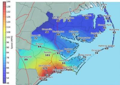
A hurricane watch and a storm surge watch have been issued for the East Coast from Edisto Beach, South Carolina to the North Carolina-Virginia border, including the Pamlico and Albemarle sounds.
At 8 a.m. Tuesday, the center of Hurricane Florence was near 26.4 degrees north, 64.6 degrees west or about 950 miles east-southeast of Cape Fear.
Florence is moving toward the west-northwest at about 15 mph and is expected to approach the North Carolina or South Carolina coast Thursday.
Hurricane-force winds extend outward up to 40 miles from the center and tropical-storm-force winds extend outward up to 150 miles.
The National Weather Service office in Newport warns that widespread power and communication outages are likely and many roads may be blocked by debris. Large trees may be snapped or uprooted.
Coastal County Information
Updated 3 p.m. Tuesday
- Beaufort County: State of emergency issued at 5:30 p.m. Monday, which will remain in effect until further notice. All of Beaufort County is currently under a voluntary evacuation. A mandatory evacuation has been issued for all low lying areas.
- Bertie County: Voluntary evacuation for waterfront properties and low-lying flood prone areas is in effect by 8 p.m. Wednesday.
- Brunswick County: Under a state of emergency as of Monday. Mandatory evacuations for low-lying and flood-prone unincorporated areas and voluntary evacuations for all other unincorporated areas began at 7 a.m. Tuesday. Residents who live in an incorporated area should monitor information from their town or city for information.
- Camden County: A state of emergency was declared at 8 a.m. Tuesday.
- Carteret County: A state of emergency was declared Sunday. Mandatory evacuation began at noon Tuesday. Citizens and visitors should plan to be at a safe location and sheltered by 8 p.m. Wednesday.
- Chowan County: A state of emergency was declared at 1 p.m. Monday. No evacuations have been ordered for Chowan County or Town of Edenton as of 5:30 p.m. Monday.
- Craven County: A state of emergency went into effect at noon Monday. A mandatory evacuation is effective as of 2 p.m. Tuesday.
- Currituck County: A state of emergency has been declared and a mandatory evacuation at noon Tuesday for everyone in the Outer Banks areas of Corolla and Carova has been issued. All alcohol sales in the county were suspended at 7 a.m. Tuesday.
- Dare County: In a state of emergency, a mandatory evacuation order for all visitors and residents on Hatteras Island took affect noon Monday. This includes all areas of Hatteras Island including the villages of Rodanthe, Waves, Salvo, Avon, Buxton, Frisco and Hatteras Village. A mandatory evacuation for residents and visitors in other areas of Dare County went into effect at 7 a.m. Tuesday. This includes the towns of Duck, Southern Shores, Kitty Hawk, Kill Devil Hills, Nags Head, Manteo, Roanoke Island and the Dare County mainland.
- Gates County: Hurricane Florence information for Gates County residents from Gates County Emergency Management.
- Hertford County: Under a state of emergency as of 8:30 a.m. Tuesday. According to a Facebook post Monday, there is no curfew or other restrictions.
- Hyde County: The state of emergency went into effect at noon Monday. A mandatory evacuation of Ocracoke Island for visitors went into effect noon Monday. The county board of commissioners extended the mandatory evacuation order to encompass all of Hyde County, mainland and island, effective at noon Tuesday.
- New Hanover County: Under a state of emergency as of Monday, a voluntary evacuation for all of New Hanover County is recommended, including Carolina Beach, Kure Beach, Wrightsville Beach and the City of Wilmington.
- Onslow County: A state of emergency was issued Monday for unincorporated areas. The only mandatory evacuation is for North Topsail Beach as of 9 a.m. Tuesday. A mandatory evacuation for all citizens of the unincorporated areas of Onslow County is in effect as of mid-day Tuesday.
- Pamlico County: Mandatory evacuation for the county goes into effect at 3 p.m. Tuesday. A state of emergency went into effect Monday.
- Pasquotank County: A state of emergency took effect 8 a.m. Tuesday.
- Pender County: Officials declared a state of emergency. Topsail Beach will have mandatory evacuation at 8 a.m. Wednesday and the Surf City mandatory evacuation is at 4 p.m. Tuesday. A voluntary evacuation is set for 8 a.m. Wednesday for low-lying, flood-prone areas of the county, including the Intracoastal Waterway, Northeast Cape Fear River, Black River and those who reside in manufactured or substandard housing.
- Perquimans County: As of Tuesday morning, there were no evacuations or shelters determined. Those that reside in a low-lying area or a mobile home should plan accordingly.
- Tyrrell County: No information on town website as of 3 p.m. Tuesday.
- Washington County: the county and municipalities of Plymouth, Roper and Creswell have declared a state of emergency effective at 8 a.m. Tuesday and a voluntary evacuation of all residents located within low-lying areas or within mobile homes.
5 p.m. Monday
Hurricane Florence continues to grow in size and strength, the National Hurricane Center said late Monday.
At 5 p.m. Monday, the eye of Hurricane Florence was near latitude 25.4 degrees north, longitude 61.1 degrees west. Florence was moving toward the west-northwest at about 13 mph with an increase in forward speed expected during the next couple of days. A turn toward the northwest was forecast to occur late Wednesday night.
The center of the storm is expected to approach the coast of South Carolina or North Carolina on Thursday.
Maximum sustained winds have increased to about 140 mph with stronger gusts, making it a Category 4 hurricane on the Saffir-Simpson Hurricane Wind Scale. Further strengthening is anticipated. National Oceanic and Atmospheric Administration aircraft data also show the area of hurricane-force winds has doubled during the previous 12 hours.
Significant Storm Surge
Florence is forecast to generate significant storm surge along the North Carolina coast, according to an analysis by the Program for the Study of Developed Shorelines at Western Carolina University.
“If the projected track and intensity modeling holds, this will be a worst-case scenario storm,” according to a document circulated Monday by Rob Young, director of the Program for the Study of Developed Shorelines.
If the storm makes landfall near Cape Fear, barrier islands in Onslow Bay could experience “complete overwash,” according to the document, with Topsail Island particularly exposed. “North Topsail Beach is at greatest risk because many areas are already vulnerable. Storm surge heights could be expected to exceed previous records.”
The highest storm surge measurements on record for coastal North Carolina towns occurred during the following storms:
- Sunset Beach: Hazel in 1954, 18 feet above mean sea level.
- Carolina Beach: Fran in 1996, 13.5 feet above mean sea level.
- Wrightsville Beach: Fran in 1996, 11.6 feet above mean sea level.
- Topsail Island: Fran in 1996, 14.6 feet above mean sea level.
The storm surge for Sunset Beach in 1954 was the highest on record for the area between Cape Lookout and Myrtle Beach, South Carolina.
More Evacuation Orders
Also on Monday, Hyde County officials issued a mandatory evacuation of Ocracoke Island for residents and non-resident property owners in addition to the previously announced mandatory evacuation of visitors. Alcohol sales on the island are to be suspended at 5 p.m. Tuesday.
Currituck County also declared a state of emergency and issued an evacuation order for vacationers and guests in the Outer Banks areas of Corolla and Carova to begin at 7 a.m. Tuesday.
The Department of Transportation’s Ferry Division said Monday it is working to evacuate all Ocracoke visitors and residents from the island.
The Ferry Division is also closing the Southport-Fort Fisher ferry route as of 7:30 p.m. Monday to move the M/V Southport and the M/V Fort Fisher to safer mooring locations.
Hyde County issued a mandatory evacuation order for Ocracoke visitors starting at noon Monday and for residents beginning 5 a.m. Tuesday.
The Ocracoke-Swan Quarter route will add a 6:30 p.m. departure from Swan Quarter and a 9:30 p.m. departure from Ocracoke to accommodate evacuees. Ocracoke-Hatteras and Ocracoke-Cedar Island routes will run on schedule, according to the ferry division.
Priority boarding will be suspended for all vessels leaving Ocracoke and tolls have been waived for ferries heading from Ocracoke to Cedar Island or Swan Quarter.
Residents, homeowners or vendors with an Ocracoke re-entry sticker on their vehicles will be allowed on ferries to Ocracoke.
“This is the biggest storm to head for our coast in decades,” said Ferry Division Director Harold Thomas in a statement. “We hope everyone on Ocracoke Island will take heed and leave as soon as possible.”
Ocracoke residents can evacuate through Hatteras even though Dare County issued a mandatory evacuation order for the island at noon Monday.
Evacuation procedures will remain in effect for all Ocracoke-bound ferries until Hyde County emergency officials lift the evacuation order.
Also on Monday, town officials in Topsail Beach said mandatory evacuations will begin there at 8 a.m. Wednesday.
2 p.m. Monday
RALEIGH — Coastal storm surge, damage from high winds and widespread flooding from heavy rainfall from Hurricane Florence could spell a major disaster throughout the state, Gov. Roy Cooper said in his initial press briefing on Hurricane Florence Monday morning.
“North Carolina is no stranger to hurricanes. We are a resilient state and resilient people,” Cooper said. “Experiences like Hurricanes Matthew, Floyd and Fran have shown us that storms and heavy wind and rain can effect the entire state, so we must all be alert and ready.”

Cooper, speaking at the State Emergency Operations Center in Raleigh, said the prospect for widespread damage makes it harder to allocate resources to a single region, because the powerful storm will likely pack a hard punch inland as well as on the coast.
The governor said he has put in a request to federal officials for a disaster declaration to free up additional resources and federal assistance.
The National Hurricane Center said that, as predicted, the storm was increasing in intensity and upgraded to a Category 4 hurricane Monday and estimated wind speeds will stay at hurricane strength as it moves slowly inland through eastern North Carolina.
Cooper urged residents to take the threat from the storm seriously. “North Carolina is taking Hurricane Florence seriously and you should, too. Get ready now,” the governor said.
Division of Emergency Management director Michael Sprayberry said state and local officials in counties along the Neuse, Tar and Lumber rivers are considering targeted evacuations for communities where flooding is likely to occur. Improvements to the state’s floodplain mapping system allows officials to be able to better predict heavy flooding ahead of time and start evacuations sooner.
Cooper on Friday declared a state of emergency. The governor also temporarily waived certain restrictions for trucks and heavy vehicles to help farmers harvest and move crops and livestock ahead of the storm and help utilities and other equipment be ready to respond if needed.
North Carolina Emergency Management is coordinating with the counties, the Federal Emergency Management Agency and key emergency response partners, including all state agencies as well as utility representatives, volunteer agencies active during disasters and others.
Department of Transportation crews in all 100 counties are taking steps in advance of the storm.
The governor urged residents to download the state’s ReadyNC app to keep up with evacuations and emergency information.
Kirk Ross contributed to this report.
12:45 p.m. Monday
N.C. COAST — With maximized sustained winds measured at near 130 mph, Hurricane Florence has continued to rapidly strengthen and is now a Category 4 storm, according to a report issued at noon from the National Hurricane Center.
Officials have already begun to take action, including designating local states of emergency and ordering evacuations along the Outer Banks.
At noon Monday, the eye of Hurricane Florence was near latitude 25 degrees north, longitude 60.2 degrees west and moving west at about 13 mph. A west-northwestward motion with an increase in forward speed is expected during the next couple of days, forecasters said. A turn toward the northwest is forecast to occur late Wednesday night. The center of the storm is expected to approach the coast of South Carolina or North Carolina on Thursday.
According to satellite data, maximum sustained winds have increased to near 115 mph with higher gusts. Hurricane-force winds extend outward up to 30 miles from the center and tropical-storm-force winds extend outward up to 140 miles.
The National Hurricane Center warned of life-threatening storm surges and flooding along the coast the Carolinas and Virginia.
In Brunswick, Bertie, Carteret, Craven, Dare, Hyde, New Hanover and Pamlico counties, a state of emergency was in force Monday. The town of North Topsail Beach also declared a state of emergency and ordered a mandatory evacuation beginning at 8 a.m. Tuesday.
A mandatory evacuation order for all visitors and residents on Hatteras Island was to take effect at noon Monday. This includes all areas of Hatteras Island including the villages of Rodanthe, Waves, Salvo, Avon, Buxton, Frisco and Hatteras Village.
A mandatory evacuation for residents and visitors in other areas of Dare County goes into effect at 7 a.m. Tuesday. This includes the towns of Duck, Southern Shores, Kitty Hawk, Kill Devil Hills, Nags Head, Manteo, Roanoke Island and the Dare County mainland.
A mandatory visitor evacuation of Ocracoke Island went into effect at noon Monday.
Brunswick County issued a mandatory evacuation at 7 a.m. Tuesday for residents in low-lying and flood-prone unincorporated areas or substandard or mobile homes. The county issued a voluntary evacuation for all other residents in unincorporated areas. Residents who live in an incorporated area should monitor information from their town or city for information.
Gov. Roy Cooper declared Friday a State of Emergency for North Carolina and temporarily waived certain restrictions for trucks and heavy vehicles to help farmers harvest and move crops and livestock ahead of the storm and help utilities and other equipment be ready to respond if needed.
“Everyone in North Carolina needs to keep a close eye on Florence and take steps now to get ready for impacts later this week,” Gov. Cooper said in a statement Sunday. “State emergency management, transportation, health experts and others are making sure North Carolina is prepared for the storm, and I urge the public to review your emergency plans and gather your supplies now.”
Cape Lookout National Seashore, Cape Hatteras National Seashore, Fort Raleigh National Historic Site and Wright Brothers National Memorial close at noon Monday, officials announced.
The University of North Carolina Wilmington issued a voluntary evacuation effective noon Monday and canceled classes and all university-sponsored events and athletics.
The N.C. Division of Marine Fisheries in a press release Monday reminded fishermen to begin getting ready for the storm. DMF suggested that fishermen remove fishing gear from the water, especially crab pots and gill nets, which are prone to damage and displacement during storms. Boat owners should check safety equipment and make plans to either remove or secure their vessels.
Information about other hurricane preparations, as well as a free mobile app, can be found on the state Division of Emergency Management’s website at www.ReadyNC.org.


