EASTERN NORTH CAROLINA — Floodwaters are starting to recede upstream along the Tar, Pamlico, Cape Fear and Neuse rivers, but an increasingly contaminated flow of freshwater is headed downriver, eastward to the coast.
The short-term prospects don’t look good for those ready for their first taste of local oysters this season.
Supporter Spotlight
Throughout the river basins, sounds and tidal areas of Eastern North Carolina researchers, environmental advocates and an array of state agencies are gearing up testing to get an idea of what effects the floodwaters are likely to have.
The template for anticipating Matthew’s continuing effects has been 1999’s Hurricane Floyd. And like the aftermath of that disaster, much of the concern right now is what happens to Pamlico Sound, the nation’s second largest estuary.
Ben Peierls, a researcher with the University of North Carolina’s Institute of Marine Sciences in Morehead City, said teams from the institute began sampling the Neuse River on Monday, looking for a range of effects.
He said researchers will be sampling for dissolved oxygen chlorophyll and measuring the amount of organic matter in the river. For now, he said, the sheer amount of moving water will probably reduce some of the possible effects.
“With Matthew, as in Floyd, there’s a lot of water coming down. It probably contains a good amount of nutrients as it washes through the watershed, but at the same time you can get a dilution effect,” Peierls said. “The more you wash out, the less that’s in there, so the concentrations aren’t always as extreme as they might be. But you’re still bringing a lot of water and a lot of particulate matter with that water.”
Supporter Spotlight
With heavy water flow, he said, the effects of additional nitrogen, which could lead to algae blooms, might not be as great. “If you have a lot of water moving through the system there’s not time for biomass to accumulate.”
How the surge of freshwater flowing down the Neuse will influence the estuary is also a focus, Peierls said. A major concern is stratification, in which a top layer of freshwater reduces the amount of dissolved oxygen in the saltier waters below. That can put stress on fish and potentially lead to fish kills.
“If the freshwater becomes more of a lens on top, and we get salty water underneath and the temperatures are high enough, that generally is a recipe for oxygen decline,” Peierls said.
Flying the Rivers, Planning for Tests
Cape Fear Watch Riverkeeper Kemp Burdette is part of a group of North Carolina riverkeepers who have spent more time reviewing the effects of Hurricane Matthew from the air than from the water.

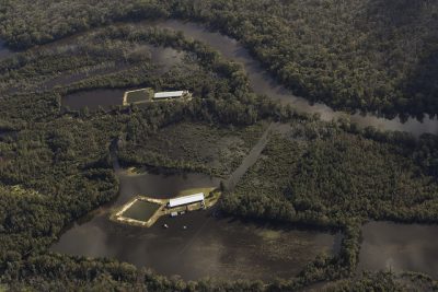
Riverkeepers and environmental advocates took to the skies shortly after Matthew cleared the coast, keeping an eye on hog waste lagoons and other potential sources of significant contamination.
In an interview Tuesday, Burdette said that although he hasn’t seen any breaches, there were several waste lagoons in the Black River and Northeast Cape Fear River watersheds that were surrounded by floodwaters.
“I saw lots of lagoons that were totally surrounded by water and there appeared to be just inches between the tops of the berms and the floodwaters,” he said.
Inundated lagoons have been spotted by riverkeepers in the Tar, Neuse and Cape Fear river basins. State agriculture officials estimated late last week that at least 11 waste lagoons had been flooded.
Burdette said the flights he’s made over southeastern North Carolina revealed just how widespread the flooding was, as well as the effects. He said that in addition to seeing flooded barns and fields, it was easy to spot petroleum slicks atop the water.
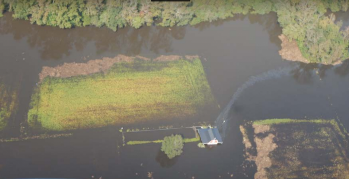
“When I was flying, the landscape was so flooded,” he said. “You could see something flowing into the water out of barns or from other sites, but you couldn’t get an idea of what it was or how much.”
Plans for testing for contaminants and the effects of Matthew have started, Burdette said, but for now the waters are too high to get an accurate sample.
“We’ve been waiting for the water to get down to a point where it is reasonable to start testing,” Burdette said. “It’s just everywhere right now.”
Another major concern is the disposal of massive numbers of livestock that died in the flooding. According to early estimates by the state, more than 2 million chickens and turkeys and several thousand hogs have been killed so far.
Oyster Harvest Delayed
Oyster season opened as announced on Oct. 15, but the harvest is halted at nearly every spot on the North Carolina coast.
That would have been certain given just the heavy rains the storm dumped on the coast and more than 100 miles inland, but with the prospect of a lot of nutrients flowing downstream, the state is stepping up testing as it reviews when it’s safe to reopen the oyster beds.

Shannon Jenkins, Shellfish Sanitation and Water Quality section chief for the North Carolina Division of Marine Fisheries, said four water-testing teams are working along the coast to determine whether beds can be opened.
Jenkins said some portions of Pamlico, Core, Back and Bogue sounds are open, but the most productive areas are not.
“Effectively, most productive oyster areas are closed due to the rainfall and coastal flooding,” he said.
Most were closed early because of the amount of rainfall, which in some areas reached 15 inches in less than a day.
Jenkins said given the stretch of dry weather, he expected areas to begin to open up soon. Harvesting areas where water tends to move faster, such as near inlets and in faster flowing rivers, are likely to be first to open, he said.
“Some water bodies and watersheds are quicker to return to normal,” Jenkins said. As an example, he said, a faster-moving river, such as the New River, is likely to return to satisfactory status sooner than the slower-flowing Newport River.
Crews began sampling in Brunswick County on Monday and were working Down East beds in Carteret County on Tuesday.
Jenkins said if the weather holds he expects most areas to be open by the start of the mechanical harvest period in mid-November.


