This story was compiled from two articles that appeared in the Outer Banks Voice.
Dare County tourism officials voted Monday to spend $300,000 as county’s share for dredging Oregon Inlet, which has shoaled so badly that the Coast Guard last month took the unusual step of assuming broader power to regulate inlet boat traffic.
Supporter Spotlight
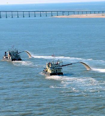
The Dare County Tourism Board approved the grant to help secure matching funds from an agreement with the state and the Army Corps of Engineers. The money will be used to allow the Corps to dredge out the channel under and just east of the navigation span of the Herbert C. Bonner Bridge.
Tim Cafferty, vice chairman of the tourism board, told commissioners that his panel recognized the emergency in approving the grant. He said continued grant funding would be more difficult. “It is our understanding that matching funds are available if we start with a $300,000 giving, if you will, the state will come help us here on what is truly a federal problem,” he said.
The tourism board is funded by occupancy tax money paid on hotels and vacations rentals. The board provides grant money for projects that would benefit tourism. The Board of Commissioners must approve the grants, but the commissioners in this case requested the grant and included it in the county’s budget.
Estimates to keep the channel at the specified 14 feet depths would cost as much as $14 million a year. But federal funding has been reduced to around $1 million.
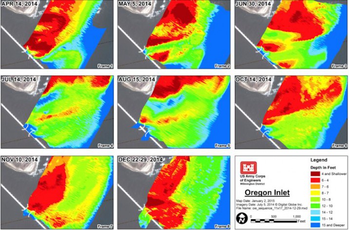
Depths around the bridge have been less than three feet in some areas.
Supporter Spotlight
No timetable has been announced for any new dredging projects in Oregon Inlet.
Shallow conditions at Oregon Inlet have forced even the smallest boats to risk passing under the bridge where there are no fenders protecting the bridge support pilings. The Coast Guard is responsible only for federal channels and has discouraged using other routes under the Bonner Bridge but has not had the power to prevent it. But the Coast Guard said new rules allowing quick action were necessary because boats routinely run between unprotected pilings south of the marked channel.
“The Coast Guard will impose restrictions only when necessary based on inlet conditions, and will provide the public with as much advance notice as possible,” a Coast Guard statement said.
Enforcement power anywhere within 100 yards of the span is essential now “to reduce the risk of a bridge strike resulting from a vessel transiting through alternative spans of the Herbert C. Bonner Bridge, which are not intended for navigation,” said a notice in the Federal Register announcing the new rules.
“A bridge strike to un-fendered or unprotected structural elements of the Bonner Bridge would introduce a clear and present danger to stability of the bridge, motorists, mariners, and indirect impacts on local businesses and residents of Hatteras Island, N.C.”
The notice said that a recent bridge inspection by the N.C. Department of Transportation “noted weakened pile supports as a result of section loss and substructure erosion to the point of showing exposed rebar.”
Soundings done last year by the Army Corps of Engineers show the ebb and flow of shallow water, shown in shades of red, under the Bonner Bridge. Illustration: Army Corps of Engineers
Oregon Inlet is the only passage to the Atlantic on the northern Outer Banks. Commercial fishing vessels and charter boats can use Hatteras Inlet, which to most is impractical. In addition, Hatteras Inlet is facing its own problems with shifting shoals.
Under recent contracts for just over $1.2 million, repairs will be made to the underside of the bridge deck and to steel support braces on the south end of the span.
Efforts to replace the 50-year-old bridge with a new parallel span have been delayed by a lawsuit filed by environmental groups. The state has awarded a construction contract for the work, and the parties in the suit are now trying to work out a compromise.
The source of contention is the plan to manage erosion problems along N.C. 12 between the inlet and Rodanthe with a series of bridges and beach re-nourishment in the Pea Island National Wildlife Refuge. The environmental groups are pushing for a longer bridge around the old right-of-way, which routinely washes out during storms.
Even after a massive emergency dredging project costing $7 million last year, the inlet quickly filled with sand again. A survey earlier this month showed the navigation channel and areas south of it shoaled to as little as 3 feet or less.
Vessel groundings have become more frequent, but the prospects for reliable federal funding are dim. Some of the maintenance dredging is being done by the Army Corps of Engineers through Memorandums of Agreement that allow the state to provide the money.
Engineers say that the new parallel Bonner Bridge will be built to allow vessels to pass much farther south, where depths exceed 30 feet.


