This story was compiled from recent reports by Rob Morris in the Outer Banks Voice and Catherine Kozak in the Island Free Press.
NAGS HEAD — Beach sand is a fickle thing. It gets pushed around by winds and waves, and you can never tell with any certainty where it will end up, despite the best engineering and intentions.
Supporter Spotlight
Take Nags Head, for instance. Too much sand there is burying walkways, swimming pools and septic fields under drifting dunes, while down on Hatteras Island an abundance of sand is clogging a ferry channel and a scarcity of it could once again threaten a roadway.
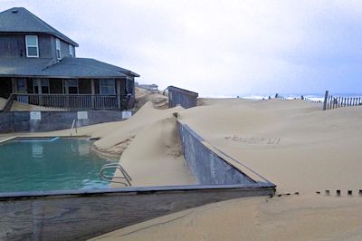
Sand is drifting into this pool in Nags Head. Photo:Town of Nags Head |
Some of the Nags Head sand that was pumped onto the beaches during the town’s massive widening project two years ago is not sliding back into the ocean. Instead, it’s piling up and over the dune line, mainly south of The Village at Nags Head.
Last week, the town’s Board of Commissioners agreed to ask the state to allow exceptions to limits on how much sand can be moved from private property and back onto the beach with bulldozers and other equipment.
One concern is that without such an exception, property owners would have to haul the sand off to get rid of it.
Supporter Spotlight
Elizabeth Teague, Nags Head’s Planning and Development director, said that a decision by the state Division of Coastal Management is expected in 30 days. The amendment would be to the Coastal Area Management Act permit that the town received for beach re-nourishment and maintenance. Town officials have been working with the division on ways to address the problem.
Time is running short because turtle nesting season starts at the beginning of May.
A series of storms with intense northeast winds this winter has made things worse. A look around the area reveals that stairways to the beach have almost disappeared. Sand is filling at least one swimming pool and migrating toward others.
Town Engineer David Ryan told commissioners that the mountains of sand threaten to make access to some septic fields impossible without digging up the dunes.
“You’ve got a drier, wider beach with prevailing northeast winds in the wintertime so that there’s nothing there to go ahead and capture the sand other than sand fencing in place if you don’t have any vegetation to capture that,” he said.
The board included language that requires homeowners to obtain permission from the town. The town will oversee the work, which is limited to Monday through Friday from 8:30 a.m. to 5 p.m.

Sand covers walkways in Nags Head. Photo: Rob Morris, Outer Banks Voice |
Pushing sand off property used to be allowed if a property owner had obtained a permit from the state Division of Coastal Management. But an ordinance generally banning pushes with machinery was enacted in 2011, not long before the town’s 10-mile, $36 million widening project was finished.
Limited maintenance to remove sand from private property is still allowed, but not to the extent that might be necessary in some instances where larger volumes have drifted west.
For the most part, dune fencing and grass helps the sand stay put. The town plans next to look at measures for longer-term fixes for the sand migration.
Meanwhile, property owners will be asked to pile the sand to create a secondary fore dune, which will create a trough to slow the drifting down.
Down on Hatteras Island, there’s too much sand in the ferry channel between Hatteras and Ocracoke islands and not enough on the beach in Rodanthe. State and federal officials are working on both ends of Hatteras Island to address the issues.
An emergency beach re-nourishment project near the S-curves in northern Rodanthe is no longer considered an emergency by the federal government, but after several glitches, the project is nearly back on track.
And the Army Corps of Engineers and the state are still at work dredging Rollinson Channel in Hatteras Inlet for use by the state Ferry Division and other boats.
“All is good,” said Jamie Shern, environmental policy advisor to the state secretary of Transportation, about the emergency nourishment project. “We had to jump through extra hoops, which we jumped through.”
Shern said that the U.S. Fish and Wildlife Service unexpectedly told the state Department of Transportation about two months ago that a biological assessment, as part of a formal consultation, would be required to permit the 1.9-mile project that will widen the beach north and south of S-Curves at the south end of Pea Island National Wildlife Refuge.
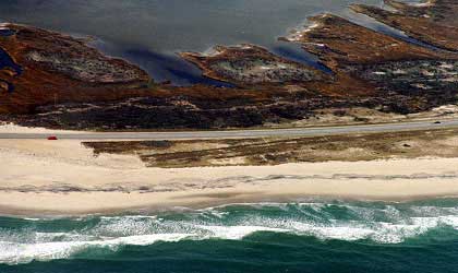
Not much beach separates rebuilt N.C. 12 north of Rodanthe from the ocean. Photo: Outer Banks Task Force |
Gov. Pat McCrory has declared a state of emergency for the Rodanthe area on N.C. 12 because of severe damage from repeated ocean overwash during coastal storms. That declaration was expected to help speed up the permitting for DOT and other agencies. The nourishment project is designed to last three years, until construction of a long-term solution for Rodanthe by Dare County.
A federal state of emergency for the same area had been declared after Hurricane Sandy two years ago, which allowed the consultation part of the permitting process to be waived. But then the federal agency decided that the emergency has passed, triggering the need for the additional study.
Shern said that nearly all the permits were in place when DOT had to put the brakes on to do the assessment, which studied the potential effects of the project on shorebirds and sea turtles protected under the federal Endangered Species Act and the Migratory Bird Treaty Act.
But DOT says the nourishment plans have not lost their urgency.
“This is still an emergency to the governor, to DOT and to the Corps, and we are still moving aggressively forward with the project,” said Nicole Meister, a DOT spokeswoman. Division staff worked all of January to complete the report, he said, and submitted it to Fish and Wildlife for a preliminary review.
With the condition to work within a limited range if a bird was seen nesting, Shern said, the assessment received positive feedback. It is currently being reviewed by the agency, which has 135 days to respond, but is expected to answer in about 60 days.
When the project was first advertised, DOT had been told it needed to be completed by May 15 to limit the effects to the protected species. But now that the biological assessment has been done, addressing protocols to protect the species, the completion date in the next bid package will be April 15, 2015.
“No contractor was interested because it was too aggressive of a schedule,” Shern said. The new timetable will be “much more palatable,” to contractors.
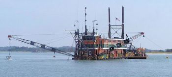
A dredge clears the Hatteras ferry channel. Photo: Dredging Today |
Shern said that DOT has requested extensions on the permits, and hopes to start the project by summer.
The Corps of Engineers received only a single bid on Jan. 10 for what is known as the Highway 12 Protection Project, but the contract could not be awarded because the contractor had added his own conditions beyond what was advertised, Ann Johnson, chief of public affairs for the Corps’ Wilmington District, said in an e-mail.
The bid was also “well above” the engineer’s estimated cost and the available funding, she said.
“The large amount of dredging work currently underway in the northeast in response to Hurricane Sandy is likely the reason more and better bids were not received,” she said. “The team is working together to re-advertise the project as soon as possible, and is looking at options to obtain more and better bids.”
By law, bid prices cannot be released, Johnson said. But DOT officials said last year that $15 million to $20 million in emergency funds for the project had been provided by the Federal Highway Administration.
Johnson said that 1.7 million cubic yards of sand will be dredged offshore from Wimble Shoals.
Meanwhile, dredges have been deployed by the Corps and the state Ferry Division to clear channels in Hatteras Inlet for ferry, charter boat and private traffic.
Roger Bullock, chief of navigation for the Corps’ Wilmington district, said that a portion of the federal Rollinson Channel had shoaled, and the dredge Currituck was working there from Jan. 10 to Jan. 14. More dredging is scheduled, he said, for the mid-to latter part of March, probably for about seven days.
“We have that channel open,” Bullock said. “It has some parts on it where the channel is narrower than the authorized 100 feet, but most of it is navigable.”
Jed Dixon, deputy director of the state Ferry Division, said that the federal channel is passable for charter boat traffic, but not the ferries.
Since Dec. 20, ferry traffic has been diverted to the emergency channel used for a few months last year. But that channel is about 10 miles and takes about an hour, versus the regular – now shoaled- channel that is 3.5 miles and takes about 40 minutes.
The state pipeline dredge Carolina has been working for the last week in Hatteras Inlet to make a new ferry channel, Dixon said.
“The new channel that we’re dredging now is a little further away from the inlet,” he said, “and we’re hoping it’s going to be more stable.”
Dixon said he hopes that the new channel will be ready for ferries within three weeks.
It’s the same channel that was run about six years ago, he said. Recent surveys revealed that it is opening up again.
“Typically, the way things happen at the inlet,” he said, “is when a door closes somewhere, it’ll open up somewhere else.”


