First of two parts
NORTH TOPSAIL BEACH – The beach here is dotted by a steady trail of houses – a mix of vacation getaways and retirement abodes. Homes are peppered along the sound side as well, and this little beach town has the distinction of having the only condominium complexes along Topsail Island’s 26-mile long shoreline.
These homes represent the fulfilled dreams of those who’ve aspired to own a little slice of paradise. But to the federal government, most of them never should have been built.
Supporter Spotlight
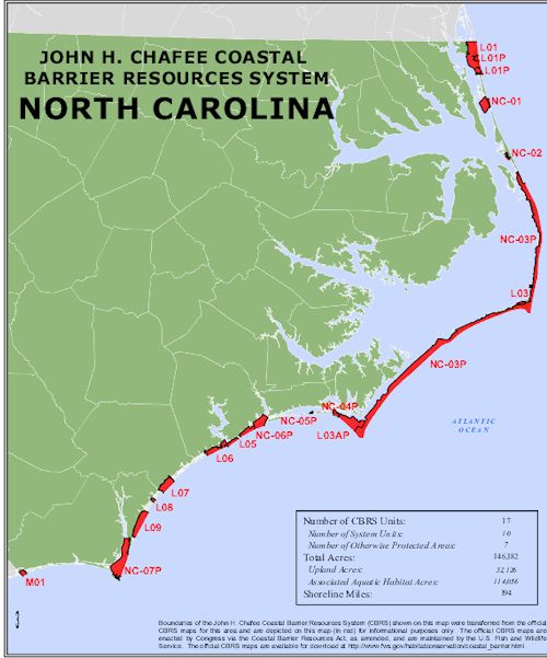
 The map shows the 194 miles of N.C. shorelines that are part of the barrier resource system. North Topsail Beach is in Unit L06. Map: USFWS |
North Topsail, then known as West Onslow Beach, was one of the places Congress had in mind in 1982 when it passed the Coastal Barrier Resources Act or CBRA (pronounced “cobra”). The law was intended to discourage building on relatively undeveloped barrier islands by cutting off federal funding and financial assistance to those who build in these hurricane-prone, biologically rich areas.
Much of North Topsail was built without the benefit of federal dollars to pay for flood insurance, roads, utilities and the other types of infrastructure people need.
Islanders, of course, disagree with their government on this. The feds, they say, made a mistake 32 years ago when they added their town to the CBRA system. It’s been the subject of a long-simmering dispute ever since. It has played out in the courtroom and will bubble over in the halls of Congress later this year when debate begins on a bill to remove North Topsail from CBRA and turn on the federal spigot.
What is CBRA
CBRA is an extension of the John H. Chafee Coastal Barrier Resources System, a collection of barrier lands protecting the shores along the Atlantic, Gulf and Great Lakes. The system includes nearly 1.3 million acres of land and associated aquatic habitat.
In North Carolina, more than 145,000 acres of uplands and their watery habitat and 194 miles of shoreline are included in CBRA.
Supporter Spotlight
But in some places like North Topsail, the designation did little to dampen people’s desires for the water. Developers aiming to fatten their wallets were all too obliged by buyers eager to own beach homes and by tourists longing to exchange the daily grind for some sunny, salty, sandy R&R.
It was a matter of supply and demand as well as what some argue is a lack of attention on the part of local and state governments as to why North Topsail and some of these other CBRA areas are now partially or fully developed.
The Government Accountability Office in 2007 examined about 90 units throughout system and found that 84 percent had remained undeveloped, 13 percent had minimal development and three percent had significant development.
Several areas within the system remain “mostly undeveloped,” according to Katie Niemi, the U.S. Fish & Wildlife Service’s coastal barrier coordinator. The federal agency administers the act.
Padre Island, Boca Chica, San Joes Island and Follets islands in Texas, Hutchinson Island in Florida and Masonboro and Lee island in North Carolina are some examples of such areas.
Then there are places like Destin, Fla., where part of the CBRA zone has been developed, and Florida’s Cape San Blas, where the entire CBRA zone has been developed, according to Niemi.
Then, there is North Topsail.
“GAO identified the N. Topsail unit as one of the units that had experienced the most extensive development,” she wrote in an email.
North Topsail’s Inclusion
 Development crowds the end of North Topsail Beach. Photo: Treasure Realtors |
The U.S. Fish & Wildlife Service is responsible for designating and mapping CBRA units. Officials there determined in the early 1980s that since the unincorporated north end of Topsail Island was largely undeveloped about 70 percent of the land met the criteria to be placed within CBRA.
In all, more than 6,000 acres were marked CBRA lands.
The designation came years after the causeway linking North Topsail Beach to the mainland was built in the 1960s. Before CBRA was enacted, Onslow County had begun providing infrastructure – roads, water, sewer and power – to the north end, according to town officials.
For this reason, they argue, the town was incorrectly designated CBRA.
The Coastal Barrier Reauthoritzation Act of 2000 defines undeveloped coastal areas in two ways. One is that development must be less than one structure per five acres of land above the high mean tide. The second is that there is not an existing “full suite” of infrastructure, including a road with a reinforced roadbed, wastewater disposal system, electric service and fresh water supply to each lot or building.
 Mayor Dan Tuman |
Niemi wrote that Fish & Wildlife is aware that a main infrastructure sewer line ran along the island when the land in North Topsail Beach was included in the system.
“Despite the existence of this main trunk line, the Service found that the majority of the island still met the CBRA criteria for an undeveloped coastal barrier,” she wrote.
But town officials say that much of the northern end of North Topsail Beach, which incorporated in 1990, had already been residentially zoned by Onslow County, under development and had a full complement of infrastructure before 1982.
For years the town has been trying to get dozens of acres removed from CBRA and re-designate its undeveloped land, primarily wetlands, as “otherwise protected areas.”
“All the yellow area is conservation district that cannot be developed,” said Dan Tuman, North Topsail Beach’s mayor, as he traced an index finger along a map sprawled across a desk in his office in Town Hall one recent September morning.
Yellow areas of the map depict the 2,155 acres of land the town has designated as conservation areas.
The town wants Fish & Wildlife Service to remove 659 acres from CBRA.
‘They Made a Mistake’
 Sen. Kay Hagan |
 Rep. Walter Jones |
“We’re not trying to get away with anything,” Tuman said. “They made a mistake. We’re trying to remedy the mistake. It’s been very frustrating.”
Legislators in 2006 reauthorized CBRA and directed U.S. Fish & Wildlife Service to hold a public comment period on draft CBRA maps created through a pilot project and to present its final recommended digital maps.
Their proposed map removes 56 structures and a little more than 75 acres of uplands, including much of the high land that is on the mainland in Sneads Ferry currently in CBRA, from CBRS in North Topsail Beach. Fish & Wildlife is proposing to add about another 10 acres of uplands, bringing the total in North Topsail Beach to 6,056 acres in CBRS.
Fish & Wildlife released its pilot project in April 2009 and ended its comment period the following August. Since then, officials there have indicated they could not revise the maps due to funding constraints.
Tuman said town officials were finally told to take their case to congress. They did.
Earlier this year, U.S. Rep. Walter B. Jones and U.S. Sen. Kay Hagan introduced bills that, if passed, would remove developed areas, including vacant lots that have existing infrastructure, from CBRA in North Topsail Beach. Jones and Hagan agree the town has provided the proof that infrastructure and development existed in North Topsail Beach before to the CBRA designation.
North Topsail Beach includes about 2,500 properties, an estimated three quarters of which are inside the CBRA zone, which also includes a little more than seven miles of the town’s 11-mile Atlantic shoreline.
If CBRA is lifted those properties will qualify for Federal flood insurance and the town would be able to apply for federal funding to help pay for beach nourishment projects.
Thursday: Why did CBRA fail?


