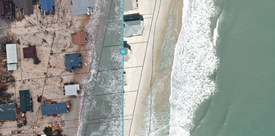
Because of recent erosion concerns, Dare County GIS staff began remotely monitoring two priority areas on Hatteras Island using drone technology.
GIS staff used the drone imagery collected so far to create a new interactive map that allows the public to view and compare images of coastal erosion over time at Old Lighthouse Road in Buxton and the northern end of Rodanthe.
Supporter Spotlight

The map, Hatteras Island Erosion Drone Imagery, features side-by-side comparisons of aerial photos of Rodanthe and Buxton. The user can select two different dates of drone imagery taken in Buxton or Rodanthe using a dropdown menu. A tool in the center of the map allows users to compare images side by side.
The map is an active and ongoing Dare County GIS project. New drone imagery is being collected and added to the map as it becomes available.
The intent of the ongoing project is to collect continual imagery that creates a historical record of erosion to help Dare County officials and other decisionmakers better understand the changing conditions and enable them to make the most informed decisions, the county said.
“The situations in Buxton and Rodanthe are very dynamic, so we wanted to have the most up-to-date information available about the current state of the oceanfront,” Dare County GIS Analyst Kristen Stilson said in a release. “We also wanted the public to be able to see the changing conditions as they are occurring, so everyone can get a better understanding of how rapidly this situation is escalating. It is one thing to see it on the news, but with the map you will be able to see the whole landscape change by just swiping between different dates.”
For more information, contact Stilson at Kristen.Stilson@DareNC.gov or 252-475-5598.
Supporter Spotlight