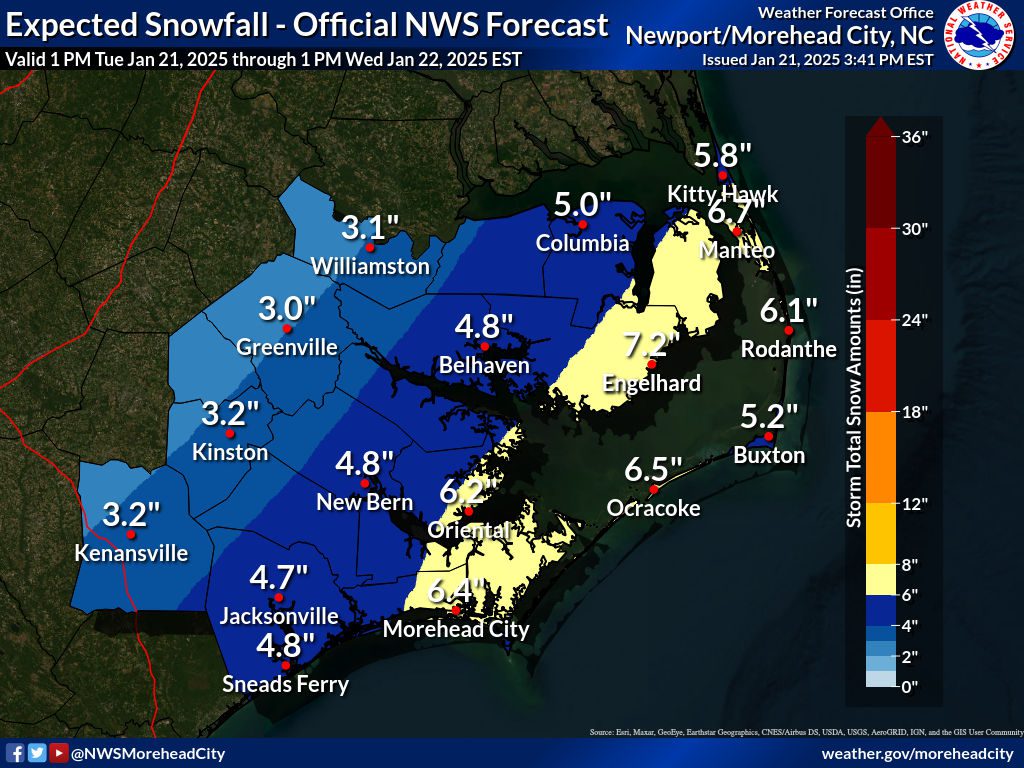
National Weather Service forecasters are expecting heavy snow and dangerously low temperatures along eastern North Carolina starting Tuesday evening and continuing into Wednesday morning.
With the coast expecting between 4 and 8 inches of snow, the possible effects have prompted a growing list of closures and cancellations for most coastal government offices from Currituck to Brunswick into Wednesday.
Supporter Spotlight
“High confidence remains that we will see an impactful snow storm starting after sunset tonight and lasting through early tomorrow morning. Blowing and drifting snow is expected, and brief blizzard conditions are also possible, especially along the Outer Banks,” meteorologists in the Newport office state in their final Tuesday briefing for the storm Tuesday afternoon.
Extremely cold weather is forecast to persist through Thursday, with morning lows in the teens and wind chills in the single digits. Highs Wednesday are unlikely to allow for a thaw, despite sunny skies. “Any snow that does melt during the daytime will refreeze into black ice at night, prolonging hazardous travel conditions for several days,” according to forecasters.
The National Weather Service Wilmington office Meteorologist-in-Charge Steven Pfaff said Tuesday to expect a recipe of snow and sleet, especially along coastal areas from near Southport to Georgetown, South Carolina.
Residents should consider the potential for heavier bands of snow that may lead to isolated higher accumulations overnight. The snow could keep falling along the coast until 5 to 8 a.m. Wednesday, Pfaff said.
In the Wilmington office’s final briefing around 4:30 p.m., forecasters said “Winter Storm Warnings are in effect everywhere, for 3-5 inches of snow over many areas with locally higher amounts.”
Supporter Spotlight
Warning Coordination Meteorologist Erik Heden, with the Newport office, noted during a late Tuesday morning briefing that this is not a typical winter weather storm, “where we see the snow, and then it’s melted and gone by afternoon. This will stick around for many days … because of the amount of snow, and also because the extreme cold temperatures, below freezing, especially at night.”
Heden said any snow that melts Wednesday will refreeze. “We’re into a stretch of cold weather that will just enhance the snow in terms of keeping it around on the ground for many days.”
Snow coupled with the wind will make traveling “quite treacherous,” because of poor visibility and slippery conditions on roadways. He added that the snow is to stop early Wednesday morning, but travel could remain hazardous for the remainder of the week, especially if the roads freeze over.
State transportation officials have a similar message. That residents should stay off the roads once the storm begins unless absolutely necessary.
“We’ve been out putting salt brine on roads since the weekend and are completing those operations to get ready for what Mother Nature brings,” said North Carolina Department of Transportation Chief Operating Officer Chris Peoples in a statement. “People should get any food and supplies they may need now so they don’t have to be on the roads later today, tonight or tomorrow morning unless it’s absolutely necessary.”
More than 800 transportation employees in eastern North Carolina have been pretreating roads and getting ready for the storm.
As of Tuesday afternoon, crews statewide had placed more than 1.7 million gallons of brine on roads. The saltwater solution lowers the freezing temperature of water to about 18 degrees, helping prevent ice from forming on pavement, according to NCDOT.
“During winter weather, just like in any severe weather situation in our state, our number one priority is keeping people safe,” Gov. Josh Stein said in a release. “Please continue to monitor local weather reports, keep off the roads if you can, and stay prepared for possible power outages.”
Multiple warming stations are opening because of the cold temperatures. County emergency managers are to report warming stations that are opening in their communities on county websites, the governor’s office said late Tuesday.
Post updated with information from the governor’s office.


