Gov. Roy Cooper on Wednesday advised that “we must be on high alert” because the slow-moving Tropical Storm Debby can bring dangerous conditions to a number of areas in the state.
Conditions including, according to forecasters, “tornadoes, heavy rains, flash floods and possible storm surge that can quickly inundate low lying areas,” Cooper said.
Supporter Spotlight
State Emergency Response Team members joined Cooper for the news conference held in person and streamed online about the slow-moving storm that was offshore of Charleston, South Carolina, at the time.
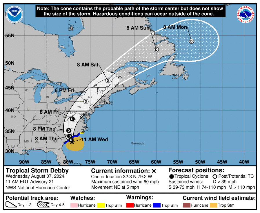
National Weather Service forecasters said Wednesday morning that they expect Tropical Storm Debby to move slowly just offshore of the South Carolina coast Wednesday, make landfall in South Carolina late Wednesday night and lift to the north through central North Carolina Thursday night and Friday morning.”
Cooper said that in North Carolina, “we’re all too familiar with rain and flooding that comes from slow-moving storms, so preparation now means saving lives later. We expect this storm to continue its slow, gradual approach, bringing multiple days of heavy rainfall and the potential for widespread and even severe flash flooding.”
Residents across the state “need to be prepared for a deluge. More rain than most of us see in a month, or even several months,” Cooper continued, adding that the southeastern region could see as much as 15 inches, and the central could see up to 10 inches. “In some areas, the rain combined with already saturated soil and winds can lead to downed trees and power lines.”
He urged residents to ready supplies in the event of power loss.
Supporter Spotlight
North Carolinians should take this storm seriously and make sure you’re ready, especially if you live in low-lying areas, which means taking care of your pets, securing your home and belongings, having a way to stay informed, and making a plan now if told to evacuate.
Cooper reminded listeners never to drive through flooded roads or around barricades.
“It only takes 6 inches of fast-moving flood water to knock over an adult and just 12 inches to carry away most cars. Now is not the time to see if your car floats, because it doesn’t,” Cooper said. “It’s not safe to drive or walk through flood waters, our Department of Transportation and our first responders will tell you that we’ve lost too many lives after these storms because of people trying to drive through or walk through water.”
Emergency Management Director Will Ray said that with the forecasted rainfall amounts for up to 15 inches across eastern North Carolina and up to 10 inches in Central North Carolina, “we are anticipating major impacts from flooding across portions of the state. Rainfall in these amounts can flood homes and businesses, erode and damage roadways, and may create situations in which local officials may need to order evacuations to ensure public safety.”
Ray noted that areas that normally do not flood may be covered in water, “and I urge you to follow the guidance of your local public safety agencies.”
Ahead of the storm, Cooper said he has activated more than 350 soldiers and airmen from the North Carolina National Guard and deployed swift water rescue teams. He declared a state of emergency Monday to help move supplies, and the state received a federal disaster declaration from President Biden Tuesday evening that will help direct federal assistance.
Ray said these 350 soldiers were provided with high-clearance vehicles and other equipment to move supplies and personnel across the state, and are prepared to assist the counties that experience flooding.
The State Emergency Response Team has distributed to nine eastern counties water pumps, tarps, meals, water generators and sandbags and other supplies, Ray said, and continue to work with partners to stage resources that support the healthcare infrastructure across the state.
“Finally, please call 911, only for emergencies. We wish to keep emergency lines open for those with life threatening situations. As we begin to see impacts here in North Carolina, please remain alert earned and check on those in your community who may need assistance together taking care of our families, our neighbors and our communities. We are stronger during a disaster,” Ray said.
State recreational water quality officials also advised on Wednesday that the public to avoid swimming in coastal waters affected by Tropical Storm Debby from Wright Memorial Bridge in Kitty Hawk south to the South Carolina State line.
“Severe weather events like tropical storms and hurricanes bring excessive amounts of rain, storm surge and cause extreme flooding. These conditions increase levels of harmful bacteria in our coastal waters that can cause illness,” Erin Bryan-Millush, manager of the N.C. Recreational Water Quality Program, said in a statement. “The sources of bacteria can vary and include failing septic systems, sewer line breaks and overflowing manholes.”
Wednesday conditions
North Carolina Emergency Management officials said on social media Wednesday morning that Tropical Storm Debby was “meandering” offshore of Charleston, with the center of Debby expected to reach the South Carolina coast by Wednesday night or early Thursday.
Officials said that they were increasingly confident that, after landfall, Debby will move quickly north-northeast through South Carolina and North Carolina on Thursday and Friday.
“The main impact from Debby is still expected to be the threat for heavy rainfall and life-threatening flash flooding,” officials said.
National Weather Service forecasters in the Newport-Morehead City office said in an 11 a.m. Wednesday update that Tropical Storm Debby would continue dumping significant rainfall on eastern North Carolina through the end of the week.
They said the main threat for eastern North Carolina would be periods of heavy rain with additional rainfall amounts of 4 to 8 inches, and locally higher amounts possible. The highest rainfall totals are expected for areas south of Highway 70.
“This will bring the threat of localized flash flooding especially in low-lying, urban, and poor drainage areas. The threat of river flooding will also increase late week into next week,” said forecasters.
Tropical-storm-force winds could begin impacting portions of eastern North Carolina by Thursday afternoon with strong winds continuing through early Friday morning, potentially bringing scattered tree damage and power outages. A few tornadoes could produce locally significant damage through Thursday night, forecasters said.
Post has been updated.


