Area meteorologists predict eastern North Carolina will feel the effects of two named storms later this week, including dangerous rip currents.
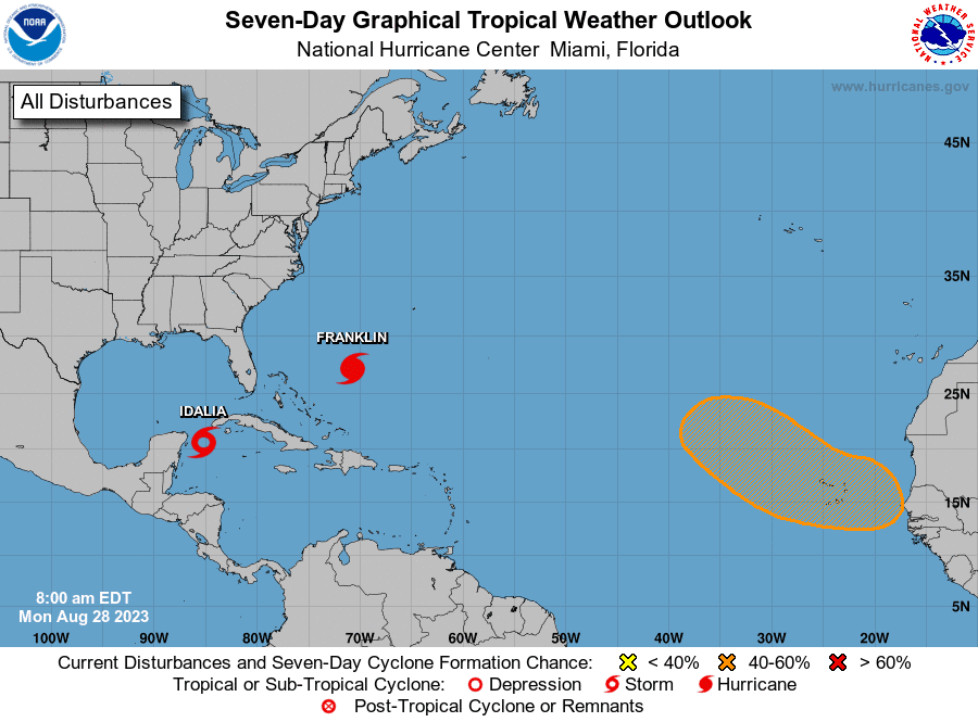
The National Hurricane Center issued at 8 a.m. Monday advisories on Hurricane Franklin, which is several hundred miles southwest of Bermuda, and Tropical Storm Idalia, which was over the northwestern Caribbean Sea.
Supporter Spotlight
The advisories come just a few weeks after National Oceanic and Atmospheric Administration forecasters upped their late-May prediction from a near-normal level of activity of 12 to 17 named storms for this year’s hurricane season, which is June 1 through Nov. 30, to an above-normal level of activity of 14 to 21 named storms.
“There is high confidence in a prolonged dangerous rip current/surf conditions and beach erosion event that will begin today and continue through the coming week as Hurricane Franklin passes offshore,” National Weather Service officials said Monday morning. “Localized ocean over wash along the Outer Banks is also possible during this time. In addition heavy rain is possible over the next few days, well before any impacts from Idalia.”
Tropical Storm Idalia was forecast to become a hurricane by Monday afternoon with a track into the northeast Gulf of Mexico. Eastern North Carolina may feel the effects as early as Wednesday night if the storm stays on its current track.
“Impacts to eastern NC from Tropical Storm Idalia look to be increasing mid-to-late week, but the extent of any impacts is uncertain at this point and largely track and intensity dependent,” officials said.
Now is the prime time of the season, mid-August through late September, with the peak around Sept. 10, National Weather Service Warning Coordination Meteorologist Erik Heden, based at the Weather Forecast Office Newport/Morehead City, told Coastal Review.
Supporter Spotlight
He said that even though NOAA expects a busier season than initially predicted in its May outlook, National Weather Service officials stress that residents should be prepared throughout hurricane season.
“We try to stress no matter the outlook, people should be preparing each and every year the same because it just takes one storm to make an impact on our lives,” Heden said, emphasizing that now is the time people should ensure their emergency kits are ready, and they have a hurricane plan in place.
“Have enough food, water, medicine for a minimum of three days on their own, with a preference for up to a week. Have at least two options to go if you need to evacuate. We like to have people have two options so they can pick the one that is the most away from the storm’s path,” he said.
Heden said that his office is hosting hurricane outreach talks through October along the coast. Locations of future talks and recording of past discussions are at www.weather.gov/mhx/hurricanecommunityforums.
The talks are typically specific to the area where it’s being presented. For example, the talk held in Manteo Aug. 23, was focused on options based in Dare County, but Heden said his talk is generic and covers having a plan, what to include in that plan, hurricane products, and other details.
In addition to the effects of the two storms, coastal residents are urged to be prepared for extreme high tides, or king tides event, through Sept. 4. A nonscientific term used to describe the predicted highest high-tide and lowest low-tide events of the year, king tides are regular and predictable events occurring multiple times a year, according to the North Carolina King Tides Project, which encourages the public to submit photos of these extreme high tide events.


