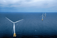
NOAA Fisheries updated existing analyses and reports on impacts of offshore wind development on commercial and recreational fisheries off the Atlantic coast.
Officials said the updates are to help the public better understand the impacts of offshore wind development.
Supporter Spotlight
The updates announced Wednesday complement previously developed analyses and include more recent updated fishing operations data, project areas, and data outputs for existing lease areas and approved project areas.
Updates include adding fishery data for 2020 and 2021 to both commercial and party/charter impact summaries for each lease area, noting that 2020 fishing operations were affected by the beginning of the global COVID-19 pandemic and may not be reflective of future fishing operations.
Individual lease areas were updated to reflect the most recent areas under consideration as reported by BOEM’s GIS website. Staff also added new tables that summarize fishery landings and revenue by landing port and state, and the number of business entities fishing within the boundaries of each project.
“All of these updates, except for the number of business entities, are also integrated into the data query tool, which enables users to organize the data to meet their individual needs,” officials said. “Together, these updates provide the latest information available to help estimate the potential impacts of offshore energy leases and approved projects on regional commercial and party/charter fisheries and associated fishing communities.”
The socioeconomic impact reports and data query tool are both available online.
Supporter Spotlight
Officials said the site will be updated every June, unless otherwise noted.


