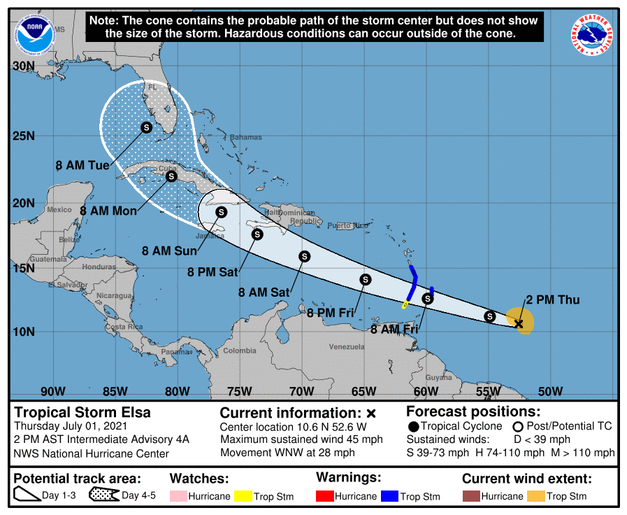
INVEST 97L, a tropical depression, was upgraded to Tropical Storm Elsa at 5 a.m. Thursday.
The tropical storm, which is about 850 miles east of Trinidad’s Port of Spain, is the earliest “E” storm in the satellite era dating back to about 1966, meteorologist Denver Ingram, National Park Service Regional Remote Automatic Weather Stations coordinator for the Southeast, wrote Thursday in an emailed update about the storm.
Supporter Spotlight
The naming of Tropical Storm Elsa so early in the season is in line with National Oceanic and Atmospheric Administration’s Climate Prediction Center, which predicted in May this year would be an above-normal Atlantic hurricane season. Though experts didn’t expect the historic level of storm activity as last year, forecasters did predict a 60% chance of an above-normal season, NOAA said.
Ingram added that the National Hurricane Center pointed out the “interesting tidbit.” Edouard was the previous earliest “E” storm in 2020 when he formed on July 6. There is little to no information about hurricanes and their impacts to North America before 1850.
According to the National Hurricane Center’s 2 p.m. Thursday update, Elsa was expected to dump heavy rain Friday morning as it makes its way across the Windward and southern Leeward Islands, move into the eastern Caribbean Sea late Friday, and head near the southern coast of Hispaniola on Saturday. Elsa is forecast to move near portions of eastern Cuba by early Sunday.
Ingram noted that the latter days of Elsa’s track forecast are less confident than the near term portion of it.
“I strongly urge folks to keep abreast of the track forecast with Elsa as it will change. Given the steep slope of the U.S. coastline, even a small change in the track can shift the impacts significantly. Gulf Coast impacts cannot be ruled out either, although I think an eastward shift is more likely than a western one,” he said.
Supporter Spotlight
The storm’s current track as of Thursday is well south of Puerto Rico and the U.S. Virgin Islands through Saturday. Over the weekend, Elsa was expected to track near or over Hispaniola, then across eastern Cuba, emerging near the Florida Keys about Monday night or Tuesday, Ingram said.
“I think the main take-away is that Florida could be affected by Elsa (wind, rain, marine impacts) Monday into Tuesday of next week,” Ingram wrote, adding that because it’s Independence Day holiday, it’s likely there are many vacationing there taht week. “It’s also entirely possible that the track continues to shift further east and that would change the impacts to Florida.”
He said a significant eastward shift could open up South Carolina to impacts later in the week.


