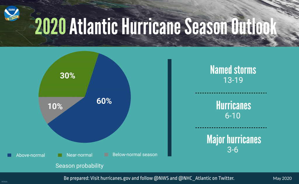
With 13 to 19 named storms predicted to form this year, forecasters expect 2020 to have an above-normal Atlantic hurricane season, which begins June 1 and ends Nov. 30.
The National Oceanic and Atmospheric Administration’s Climate Prediction Center, a division of the National Weather Service, announced Thursday that forecasters predict a 60% chance of an above-normal season, a 30% chance of a near-normal season and only a 10% chance of a below-normal season.
Supporter Spotlight
“Unfortunately, and it’s kind of what we’ve been used to over the last couple years, looks like another active season,” Warning Coordination Meteorologist Erik Heden with the National Weather Service Weather Forecast Office Newport/Morehead City said Thursday afternoon during a webinar on 2020 hurricane outlook.
The forecast shows a likely range of 13 to 19 named storms with winds of 39 mph or higher. Of those, six to 10 could become hurricanes with winds of 74 mph or higher and include three to six Category 3, 4 or 5 major hurricanes with winds of 111 mph or higher. NOAA provides these ranges with a 70% confidence, according to the Climate Prediction Center. An average hurricane season produces 12 named storms, of which six become hurricanes, with three becoming major hurricanes.
“As Americans focus their attention on a safe and healthy reopening of our country, it remains critically important that we also remember to make the necessary preparations for the upcoming hurricane season,” said Secretary of Commerce Wilbur Ross. “Just as in years past, NOAA experts will stay ahead of developing hurricanes and tropical storms and provide the forecasts and warnings we depend on to stay safe.”
Heden said it doesn’t really matter in terms of how many or how little storms we have in any given year, “it matters, is it the one that hits our area. It only takes one storm,” he said, and recalled the storms of 2017: Harvey, Irma and Maria. That year was very active with 17 storms, six of which were major hurricanes. “But as far as we’re concerned here in North Carolina, it was a quiet year.”
He then asked, “Do you remember 2018? I know the answer. Of course you do, Florence and Michael.”
Supporter Spotlight
He said that year there were less storms, less hurricanes and less major hurricanes, “but did it really matter? We were directly impacted by two major storms in our region. The whole point of that is, you should be preparing each and every year” for at least one storm. “Even if we were saying it was going to be a weak year, it doesn’t mean we can let our guard down.”
He said that the peak of hurricane season is roughly the middle of September, when the water is the warmest.
“We had Dorian and Florence about the peak of hurricane season, that’s when we usually see the highest impact and the most frequency of storms in our area,” he said, adding that Arthur last week shows “we are equal opportunity here in North Carolina.” Anytime from May on, the state is at risk for tropical cyclones, emphasizing that we should be prepared from this day forward.
There are several climate factors that make for a strong possibility for above-normal activity in the Atlantic this year, including an El Nino presence isn’t expected, which suppresses hurricane activity and warmer-than-average sea surface temperatures in the tropical Atlantic Ocean and Caribbean Sea. Additional factors include reduced vertical wind shear, weaker tropical Atlantic trade winds, and an enhanced west African monsoon all increase the likelihood for an above-normal Atlantic hurricane season, according to the Climate Prediction Center. Similar conditions have been producing more active seasons since the current high-activity era began in 1995.
“NOAA’s analysis of current and seasonal atmospheric conditions reveals a recipe for an active Atlantic hurricane season this year,” said Neil Jacobs, Ph.D., acting NOAA administrator. “Our skilled forecasters, coupled with upgrades to our computer models and observing technologies, will provide accurate and timely forecasts to protect life and property.”
He said that a lot of times there’s too much focus on the category, which is only related to wind.
“Category is only focused on wind and only tells us about how strong the winds are, it says nothing about the rainfall, the surge, rip currents, or tornadoes. Since 2010, we’ve had 175 direct deaths and over $100 billion in damage from category ones,” Heden said.
In addition to heavy rains and flooding, other major impacts are storm surge, rip currents, which have caused more deaths in the state than wind events, wind and tornadoes, a risk as soon as the bands reach us.
As with every hurricane season, the need to be prepared is critically important this year.
“Social distancing and other CDC guidance to keep you safe from COVID-19 may impact the disaster preparedness plan you had in place, including what is in your go-kit, evacuation routes, shelters and more. With tornado season at its peak, hurricane season around the corner, and flooding, earthquakes and wildfires a risk year-round, it is time to revise and adjust your emergency plan now,” said Carlos Castillo, acting deputy administrator for resilience at FEMA. “Natural disasters won’t wait, so I encourage you to keep COVID-19 in mind when revising or making your plan for you and your loved ones, and don’t forget your pets. An easy way to start is to download the FEMA app today.”
The Climate Prediction Center will update the 2020 Atlantic seasonal outlook in August prior to the historical peak of the season.


