BOLIVIA – Holden Beach is taking the state Division of Coastal Management to task for its proposal to expand the western end of the island’s inlet hazard area.
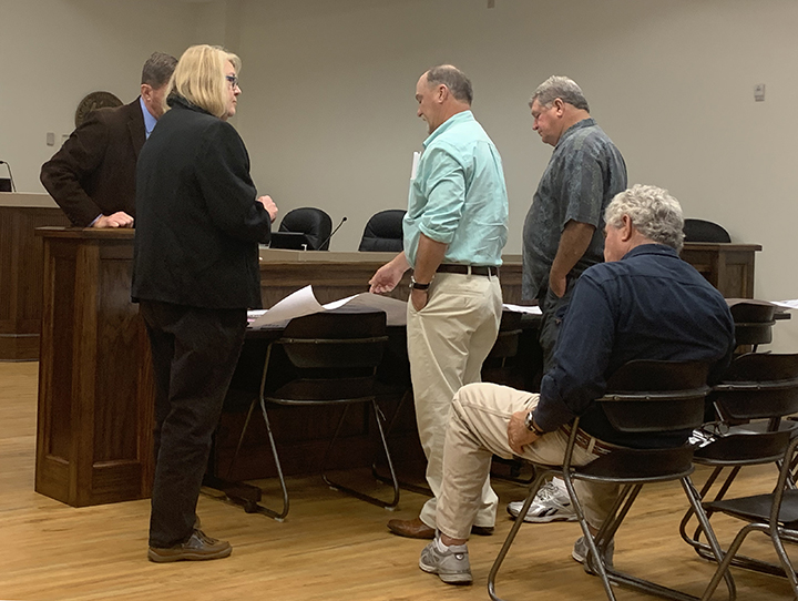
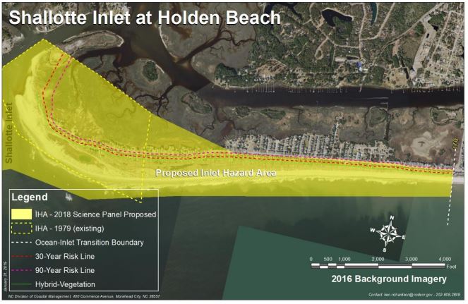
During the first in a series of public meetings the division is hosting through January, a small group of Holden Beach residents and the town’s planning director on Tuesday morning questioned a state official as to why the preliminary boundary at Shallotte Inlet stretches eastward for about 2 miles from the end of the island that is accreting.
Supporter Spotlight
“I really have concerns just about how you came up with these boundaries,” said Vicki Myers, resident and chair of the town’s Inlet and Beach Protection Board. “I think your math is wrong.”
The preliminary boundary encompasses a little more than 200 structures, nearly four times the 51 structures in the current inlet hazard area.
“This is a huge issue,” said Holden Beach Property Owners Association President Tom Myers. “To look at these numbers it makes it look like it’s the most dangerous place in the state. Just looking at it makes no sense that our west end of the island has the most houses in an inlet hazard area in the state.”
The Myerses, who are married, do not live in the current or proposed inlet hazard area, or IHA, but said expanding the area at the western end, which has been accreting since the 1970s, does not make sense.
Developed inlets
IHAs are defined as shorelines especially vulnerable to erosion and flooding where inlets can shift suddenly and dramatically.
Supporter Spotlight
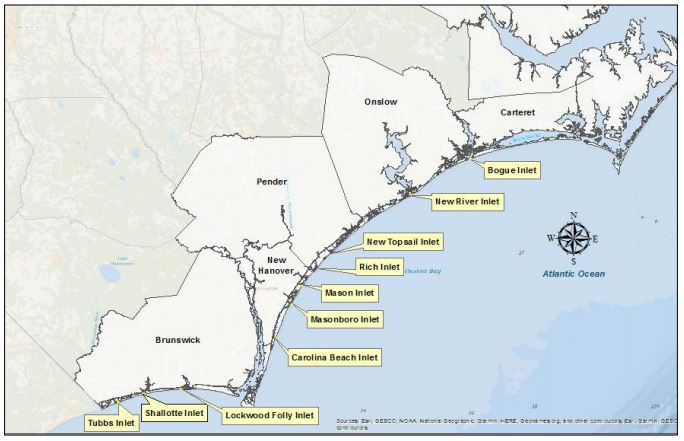
Shallotte Inlet is one of 19 active inlets in the state. Ten of those are called developed inlets. A little more than 2,900 acres at the 10 developed inlets are designated as IHAs.
Those inlets include Tubbs, Shallotte and Lockwood Folly in Brunswick County; Carolina Beach, Masonboro, Mason and Rich in New Hanover County; New Topsail and New River in Pender County; and Bogue Inlet in Carteret County.
Discussions and attempts to update IHA boundaries, which were first drawn in the late 1970s, go to back to 1998-99, when members of the first-appointed science panel suggested to the commission that the boundaries were outdated.
Current IHAs were drawn based on the historic migration of the inlet shoreline.
To establish the proposed updated IHAs, the science panel is using the hybrid vegetation line, or landwardmost position of the historic vegetation line, to determine boundaries.
The proposed maps expand current IHAs collectively by a little more than 1,359 acres while removing about 470 acres from existing boundaries at the 10 developed inlets.
Inlets typically move over time in one of two ways: An inlet migrates, meaning it moves in one general direction, or it oscillates, wagging back and forth. A majority of the state’s inlets, including Shallotte Inlet, oscillate.
In its recommendations released to the Coastal Resources Commission earlier this year, the commission’s science panel explained that the historic repositioning of the outer bar channel from the southwest to the southeast reshaped the ebb-tide delta and its effect on the adjacent oceanfront shorelines on Holden and Ocean Isle beaches.
The ebb channel has generally aligned in a southeast/east-southeast direction since the late 1960s, which has allowed sand to accrete at the western end of Holden Beach. During this same time, Ocean Isle’s oceanfront shoreline at the inlet has experienced chronic, long-term erosion.
If the ebb channel were to re-orient itself again toward Ocean Isle, then Holden Beach would erode, according to the science panel.
“I just don’t see how we can believe in the science.”
Tim Evans, Director, Holden Beach Planning and Inspections
Holden Beach Planning and Inspections Director Tim Evans said the data indicate the inlet essentially stabilized in the 1970s.
“Our vegetation line is constantly growing,” he said. “I think that Holden Beach really needs to be looked at again, especially where the original inlet hazard area was. I just don’t see how we can believe in the science.”
The new proposed boundaries come with updated rules, which include the current limit that structures within an IHA can be built no larger than 5,000 square feet of heated space and no more than one unit per 15,000 square feet of land area.
Homes and businesses that exceed the size limit within the new boundaries would be grandfathered under the new rules.
Existing structures destroyed or damaged, requiring more than 50% repair, can be rebuilt regardless of size or density as long as the structure meets the setback requirements within the IHA. Setbacks vary in each area.
If a structure does not meet the setback requirements, a structure that meets current grandfathering rules may apply. Those rules include being built before Aug. 11, 2009, meeting minimum setbacks, staying within the original footprint and rebuilt as far landward on a lot as possible.
The current preliminary boundary at the west end of Holden Beach stretches about 2 miles, Evans said.
He argued that a major storm, not inlet erosion, could damage and destroy the more than 200 homes within the proposed IHA. If those homes cannot be rebuilt because they do not meet setback conditions, that would have a significant economic impact to the town, Evans said.
More hearings scheduled
Public hearings are being hosted in counties where there are developed IHAs.
Hearings were held in New Hanover, Pender and Onslow counties Tuesday and Wednesday.
The remaining hearings are as follows:
- Jan. 7 – N.C. Division of Coastal Management office, 400 Commerce Ave., Morehead City.
- Jan. 8 – Community Center, Multipurpose Room, 30 Oyster Creek Road, Swan Quarter, and broadcast simultaneously to Ocracoke Island at the Ocracoke Community Center, 999 Irvin Garrish Highway.
- Jan. 14 –Nags Head Board of Commissioners room, 5401 S. Croatan Highway, Nags Head.
Public comments may be submitted to the Division of Coastal Management through Jan. 31, 2020.
Public comments will likely be presented to the Coastal Resources Commission at its February meeting next year. If the commission adopts the new boundaries, those may go into effect between April and May.
Written comments may be sent to Braxton Davis at braxton.davis@ncdenr.gov or Ken Richardson at ken.richardson@ncdenr.gov


