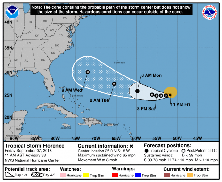
MIAMI – Large swells from Tropical Storm Florence will begin to affect portions of the East Coast this weekend as the distant storm begins to regain hurricane strength, the National Hurricane Center said Friday.
Although there was still much uncertainty in Florence’s track beyond five days out, forecasters advised residents of hurricane-prone areas to ensure they have a hurricane plan in place.
Supporter Spotlight
As of 11 a.m. Friday, the center of the storm was at 25 degrees north, 51.8 degrees west or about 935 miles east-southeast of Bermuda with maximum sustained winds of 65 mph and moving west at about 8 mph. This general motion is likely to continue through Sunday. A west-northwestward motion with an increase in forward speed is forecast over the southwestern Atlantic Ocean early next week.
Little change in intensity was expected Friday, but Florence was forecast to become a hurricane again Saturday night or Sunday as it moves over warmer waters and could potentially become a major hurricane by mid-week.
Tropical-storm-force winds extend outward up to 140 miles from the center. Storm swells are likely to cause life-threatening surf and rip current conditions.
Officials recommend that coastal residents take the following steps:
- Make sure you are familiar with your evacuation zone, the evacuation route and shelter locations.
- Gather needed supplies for at least three days, including medication and first-aid and pet supplies.
- Keep important documents in a safe place or create password-protected digital copies.
- Protect your property. De-clutter drains and gutters. Install check valves in plumbing to prevent backups. Consider hurricane shutters. Review insurance policies.


