Reprinted from the Outer Banks Voice.
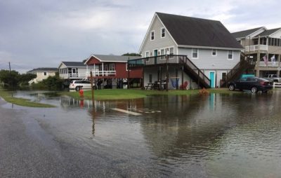
NAGS HEAD — Homes and businesses in Nags Head were inundated by rainwater twice in the span of six days recently by slow-moving thunderstorms that poured millions of gallons of water onto the town in less than two hours.
Supporter Spotlight

Water is receding about as fast as Nags Head can address chronic flooding between the Beach Road and bypass that first came to a head after Hurricane Matthew’s record-breaking rainfall.
The Outer Banks topography is not exactly ideal to handle any significant rainfall, as a “trough” probably best describes the peninsula and island chain. Man-made dunes to the east and much taller natural dunes to the west funnel water in between, where the most structures happen to be located.
Although it usually takes only a few hours for water to percolate into the sandy soil during normal rainfall, the problem is compounded by a drainage system that dates back as much as five decades and can barely handle a heavy rain when it is in perfect shape.
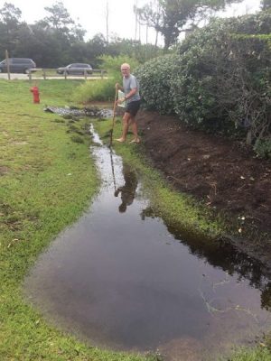
“Ditches full of sand, mud, weeds and water,” said South Wrightsville Avenue resident William Broadhurst. “The culverts under streets and storm drains are choked with weeds and debris. No flow at all. None.”
Town officials have been scrambling to do as much as they can to alleviate the flooding, but with more than 55 miles of pipes and ditches, they can only move so fast.Supporter Spotlight
“We are responding to all inquiries to assess the situation on the ground so that we can take the necessary corrective actions,” said Town Manager Cliff Ogburn.
On July 11, 3.96 inches of rain fell in just 90 minutes at Nags Head Town Hall from the same thunderstorm that garnered attention nationwide because it also spawned numerous waterspouts in the Albemarle Sound off Colington.
The connecting streets between Virginia Dare Trail and Croatan Highway from just north of the Kill Devil Hills line to South Nags Head disappeared under as much as 2 feet of water, and sections of both N.C. 12 and U.S. 158 were inundated, bringing traffic to a near standstill.
Other than video of the flooding on the Beach Road shot by The Outer Banks Voice and shared by The Weather Channel’s Jim Cantore on Twitter, there was no mention outside of Dare County about the freak storm’s flooding.
Water was still standing in the yards and driveways of the homes of permanent residents, vacation rentals and businesses from that storm and several others that passed through over the next few days, when another “frog-strangler” formed early July 16.

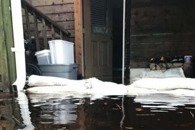
During a two-hour period, 4.97 inches of rain fell, sending up to a foot of water into the lowest level of a number of homes.
Since July 1, the town’s rain gauge has collected more than 15 inches of rain, and measurable rainfall had been recorded in 14 of the first 18 days of the month.
“We have had personnel performing maintenance activities pre-, during and post-rainfall events,” Ogburn said.
Broadhurst said the water table is now just 3 inches below the ground surface in the area where he lives, near the corner of Wrightsville Avenue and Blackman Street, and that septic tanks and drain fields are under water.
He said many residents can’t do laundry, take a shower or even flush their toilets.
According to a “Drainage FAQ” issued by the town on Tuesday, “the rainfall frequency is contributing to elevated groundwater conditions, reducing a ‘drying out’ period, as well as the ability for the Town’s drainage network to recover.”
Rainfall runoff is primarily managed by allowing it to infiltrate into the surrounding sandy soils.
But what isn’t absorbed is supposed to move through the network of “drainage infrastructure,” a third of which is owned and maintained by the North Carolina Department of Transportation, including five ocean outfall discharge points.
While those pipes are located at low points in the town, the majority of them were installed in the early 1960s in response to the Ash Wednesday Storm, which inundated nearly the entire northern Outer Banks with primarily ocean overwash.
No design records for the outfall systems are available, according to the town, but the system has a capacity of less than a two-year level of service, or a 2-inch rainfall occurring over a 24-hour period.
Along South Virginia Dare Trail, South Croatan Highway or South Old Oregon Inlet Road, the stormwater systems are owned and maintained by NCDOT.

“A significant challenge exists due to state regulations prohibiting any new outfall connections or size increase,” Ogburn said.
“This is further compounded by the outfalls having a minimal level of service, having to overcome tidal influences to function efficiently in addition to continual maintenance by keeping the pipes free of obstructions.”
The outfall pipes have no control mechanisms, such as a flood gate or valve, which regulate the outflow or inflow of water from these systems, and the town has no means or authority to close or provide maintenance to the pipes.
Kitty Hawk has been installing a system of drains and pipes in key locations since Hurricane Sandy flooded much of the area between the highways.
Temporary pumps are then placed at the end of the pipes to move the water into the ocean.
But Nags Head has yet to move beyond the planning stages on a similar system, and is in the second year of a three-year effort to update its stormwater master plan and a 10-year capital improvement plan.
“All available options will be explored to include both innovative and conventional stormwater management techniques to increase the level of service throughout the town,” Ogburn said.
“In addition, the town is currently working on the development of an emergency pumping plan, which is required to be approved by the North Carolina Department of Environmental Quality in advance of operation under emergency conditions,” said Ogburn.
“While it’s understandable the unusual rain causes unusual problems, one would think there would be crews out addressing the issue immediately after the rain,” said Broadhurst. “It’s Wednesday now and I’ve seen not a single truck or man with a shovel even. And the water remains.”
“Our initial efforts were focused on the downstream areas prior to our outfalls to ensure that all were flowing and free of obstruction,” Ogburn added.
“We are currently working our way upstream and in some of the most affected areas in an effort to alleviate flooding,” Ogburn said. “It will take some time to cover the entire town, but we ask our residents to be patient until we are able to get there.”
This story is provided courtesy of the Outer Banks Voice, a digital newspaper covering the Outer Banks. Coastal Review Online is partnering with the Voice to provide readers with more environmental and lifestyle stories of interest about our coast. You can read other stories about the Outer Banks here.


