Reprinted from the Outer Banks Voice.
NAGS HEAD — While Nags Head’s wider beach is more than holding its own three years after an unprecedented 10-mile nourishment effort, plans should start now for the next step, which ideally would include a jetty on the south end of town, the contractor who led the project says.
Supporter Spotlight
Tim Kana, president of Coastal Science and Engineering, told town commissioners last week that dunes are bigger than expected and sand loss has not been nearly as substantial as historic erosion rates might have suggested.
But on the extreme south end of the project, the surf is taking its toll, Kana said. The losses there were expected because the beach tapers down to its original width at the border with the Cape Hatteras National Seashore.
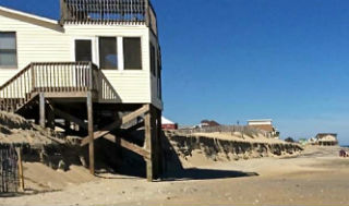
 Waves are taking their toll at the south end of Nags Head, which shows higher rates of beach erosion than its north end. The contractors who led the 10-mile beach widening project in 2011 suggest the town start making plans to put in a jetty at its south end to hold the sand in place. Photo: Rob Morris |
Ideally, a groin or jetty would minimize sand loss in South Nags Head, where the rate of erosion is much higher than it is north of Whalebone Junction, Kana said.
“The most cost-effective, long-term strategy for reducing your sand maintenance costs is to nourish and place a sand-retaining structure at the south end of Nags Head to hold the sand in place to reduce the erosion rate there down to a comparable rate to what north Nags Head is,” Kana said.
Legislators have eased a statewide ban on hardened structures along the shoreline, but only terminal groins are now allowed with limitations. Terminal groins are small jetties designed to stabilize inlets.
Supporter Spotlight
Whether the state would eventually consider allowing jetties elsewhere remains to be seen. Also worth considering is that the town borders federal land and environmental groups would more than likely mount legal challenges.
In the meantime, Kana said, the town should plan for adding more sand to the beach by starting the permitting process soon. Replenishment was originally projected to be needed after 50 percent of the sand was lost or in six years.
Overall, about 96 percent of the 4.6 million cubic yards of sand pumped onto the beach in 2011 remains in the system out to a depth of 19 feet, the distance the federal government uses to determine if a project qualifies for money to replace losses after a named storm.
The visible beach is narrower than it was after the sand was first placed, but on average it’s still about twice as wide as it was before nourishment, 80 feet compared to 40 feet, Kana said.
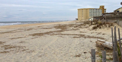
 Whalebone Junction, at the north end of Nags Head, is holding up well since the town’s beach re-nourishment project in 2011. Photo: Rob Morris |
Some of the sand was blown west to build up dunes, and some, as expected, slid into the water close to shore, where it acts to buffer storm surge and can wash back onto the beach depending on weather conditions.
A downside of the westward migration of sand is that it has blown onto property and into swimming pools in some areas. Moving it required an exemption from a Coastal Area Management Act permit and monitoring by the town.
Hotspots, including a segment where six houses close to the ocean are still the focus of legal action by the town, have seen much more erosion, Kana said.
Coastal Science’s survey last June showed that more than one million cubic yards of new sand remains between the dune and water. Eight miles of northern Nags Head gained around 10 percent while south Nags Head lost 30 percent.
Any planning should consider that sand retention will be exponentially higher the longer the project is. So pumping sand into one problematic area would not justify the cost of deploying dredges and equipment, Kana said.


