Reprinted from the Island Free Press
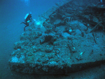 The wreck site of the USS Monitor has become popular with recreational divers. Here, one explores the bow of the ship. Photo: NOAA |
WANCHESE — Expansion of the Monitor National Marine Sanctuary could encompass nearly all of the existing wrecks off the N.C. coast, where ships were lost in storms and every conflict that raged off the coast.
Supporter Spotlight
Or the nation’s first marine sanctuary, situated 16 miles off Hatteras, could expand to include just a few more isolated but significant wreck sites.
Four draft models in various range and scope were presented last month at the Coastal Studies Institute in Wanchese during a meeting of the Sanctuary’s advisory council.
“What you see here today is sort of the first step out of the gate,” Sanctuary Superintendent Dave Alberg said.
Alberg quickly added that “every one of these is designed not to limit, not to restrict” diving activities, an acknowledgement of the intense skepticism from divers since the prospect of expansion was first raised in 2008.
Designated in 1975 to protect the remains of the famed Civil War ironclad Monitor that was lost in a New Year’s Eve storm in 1862, the sanctuary, currently is a column of water one nautical mile in diameter around the sunken vessel. The wreck was discovered in 1973 under 230 feet of water about 16 miles off Cape Hatteras. It’s managed by NOAA’s Office of National Marine Sanctuaries, .
Supporter Spotlight
During the planning process for the sanctuary management plan, finished in early 2013, some divers reacted with suspicion when they learned the management plan included the option to expand.
“In the southern Outer Banks, we all know what’s happened with the federal government,” commercial fisherman and diver Steve Wilson told Alberg at a meeting in 2012, in a comment that typified the sentiments expressed by other divers. “It doesn’t matter what reassurances we receive. Any third party can come along and blow that right out of the water.”
Comments from divers at last month’s meeting seemed to reflect the inevitability of some expansion, with mostly pragmatic rather than mistrustful questions about access, costs and regulations.
Jim Bunch, a veteran diver who presented the Expansion Working Group recommendations to the council, said that the group felt that it was important to not cause any harm to the diving and fishing communities. In the interest of protecting the resource, no removal of artifacts or disturbance of the wreck would be permitted, but fishing and anchoring over the wreck would not be restricted.
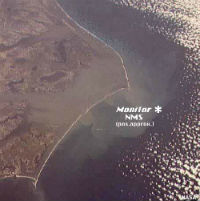 The USS Monitor sank about 16 miles from Cape Hatteras and sits in about 230 feet of water. Map: WUNC |
“I guess our overriding concern,” Bunch said, “is that people involved with these wrecks would not be detrimentally affected.”
Bunch said later that dive operations have been stretched to the limit by fuel increases and other cost-of-living pressures. Access to wrecks is important, but so is staying in business.
“Their plea was, ‘Don’t do anything to us that’s going to cost us any money,’” Bunch said. “‘We barely get by as it is.’”
In Model A, the sanctuary would include noncontiguous wreck sites, such as the well-known U-85, the HMT Bedfordshire and the U-701, but not include state waters. Model B – the working group preference – would be a compact area centered off Cape Hatteras that included several wrecks with a historic theme, for instance, North American exploration. Ideally, this would include wrecks in state and federal waters. It would maintain free and open access to ocean users and include a recommendation for a minimum 10-year sunset clause.
Model C is a hybrid of A and B that includes areas between each known site as study areas, making it easier for inclusion of wrecks discovered in the future.
Model D represents a collection of federal and state wrecks from many eras and historically significant wrecks off the Outer Banks.
Potential downsides of each of the draft models were included in the discussion material. For instance, large areas will have management and enforcement challenges, and separated areas lack connectivity.
“This is a very difficult thing for us to do because, frankly, every single shipwreck off the coast represents a story,” said Kevin Duffus, a member of the expansion advisory committee. “If I had my way, I would want to include every single shipwreck out there, especially those wrecks that resulted in loss of life. But that’s not practical.”
Joe Hoyt, also with the working group and a NOAA marine archaeologist, said that the focus was on finding a realistic way to enhance the resource – access for divers and protection of the sunken vessels – as well as the educational opportunities for the public.
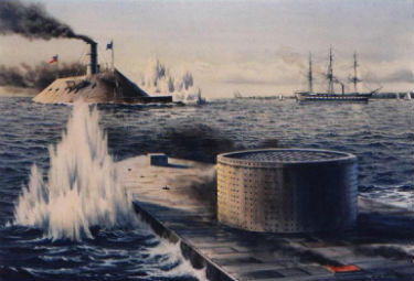 |
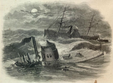 Top: The USS Monitor, foreground, and the CSS Virginia fight to a draw in Hampton Roads in March 1862 in the first battle of iron warships. Nine months later, the Monitor sinks in a storm off Cape Hatteras. Illustrations: Monitor Collection, Library of Congress |
“We knew, obviously, we couldn’t do the take-everything model,” Hoyt said. “We want to have some of those iconic ones that are representative of our maritime heritage.”
Hoyt said that multiple data bases provide details about each shipwreck — type of vessel, location, date, historic significance, even what shipping lane or inlet it went down in. With the dreaded Graveyard of the Atlantic off North Carolina having one of the greatest concentrations of wrecks in the world, there’s a lot to work with.
“This is the very beginning of a discussion of what this could look like,” he said. “This will probably change multiple times before this comes to fruition.”
After the advisory council submits its recommendation on a suitable model for expansion to NOAA, formal public scoping meetings will be held, likely in the fall, Alberg said. A draft environmental impact statement will be drafted for review, and a final plan is expected in two to three years. Opportunity for public input will be provided at all stages of the process.
“The intent here is not to take anything from anybody,” he said.
But Gary Gentile, the man who successfully sued NOAA – in four lawsuits over eight years — to force the agency to allow diving on the Monitor, remains cynical about expansion of the sanctuary and NOAA sanctuaries in general, which he accused of restricting access to wrecks and fishing at sites in other states.
“It has nothing to do with preservation –it has to do with control,” he said in a telephone interview.
Gentile, 68, who lives in the mountains in Jim Thorp, Pa., has dived all over the world, including the Outer Banks.
The fact that NOAA allowed funding of the Monitor artifact preservation at The Mariner’s Museum to lapse in January, he said, impugns their trustworthiness.
“So they let it go,” he said. “They reneged on that.”
Gentile conceded, however, that he is not objective.
“Of course, you have to imagine,” he said, “that I have a bad taste in my mouth about NOAA.”


