WANCHESE — After five meetings trying to nail down how to seize control of the most intractable inlet in the nation, it’s gotten down to the wire for the state’s Oregon Inlet Land Acquisition Task Force.
The deadline for the 11-member body to submit its report to the General Assembly is today.
Supporter Spotlight
“The task of drafting the report was given to us in late January and we are working on a thorough and complete report,” said Christopher Mears, a spokesman for the N.C. Department of Administration, in an e-mail Wednesday morning. “Our intention is to meet the May 1 deadline.”
The legislation passed last year charged the panel, which first met on Feb. 6, with “determining, reviewing, and considering” options, including condemnation, for acquiring the submerged and surrounding lands of Oregon Inlet from the federal government.
But between weighing the myriad issues with property law, coastal processes, fisheries management and economic impacts, as many questions as answers have been raised by the panel. Meanwhile, the inlet’s navigational channel, clogged weeks ago, remains impassable, an uneasy reminder of the bear the state is trying to slay.
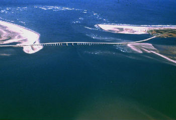
 The Oregon Inlet Land Acquisition Task Force is studying state acquisition of land at Cape Hatteras National Seashore, left, and Pea Island National Wildlife Refuge, right. Photo: N.C. Department of Transportation |
A draft report released at a meeting last week at the UNC Coastal Studies Institute includes an almost $30 million market value appraisal of the 710 acres that the state would acquire on either side of the inlet, but sidesteps details of potential land swaps or negotiations with the landowners, the National Park Service and the U.S. Fish and Wildlife Service. With the submission of the final report, the task force will be officially disbanded.
Many questions remain dangling: Will the state try to claim eminent domain? Would the feds even be willing to consider trading? How would the state pay for in-depth surveys, biological reports, geological analysis and, not to mention, the inlet land?
Supporter Spotlight
State and county officials say that Oregon Inlet is vital to the economic and environmental well-being of Dare County. The stated goal of the task force was to study how to acquire the inlet so that jetties can be built to anchor the channel. But jetty opponents say the rock walls would cause downstream erosion and harm fisheries.
“The aspect of possible exchange or acquisition of property with the federal government is a promising approach toward developing a workable and cost effective solution to the continual problems associated with keeping the Oregon Inlet channel navigable and safe,” the draft report said.
On the north side of the inlet, 530 acres owned by Cape Hatteras National Seashore were valued at $17.9 million, according to the draft report, and 180 acres owned by Pea Island National Wildlife Refuge on the south side were valued at $12 million.
“This was really difficult property to appraise,” the report said, “because there were no comparable land sales on this kind of property.”
Complicating an already complex situation is the disputed ownership of a 298-acre parcel on the north side of the inlet, which may or may not be accreted land owned by a man who has paid taxes on it for years.
Norm Shearin, a lawyer in Dare County who has expertise in property rights issues, has been hired by the state to do a title search of the property.
The draft report noted that earlier discussions had been held with Fish and Wildlife officials about potential land exchanges. But David Viker, refuge chief for the southeast region of the U.S. Fish and Wildlife Service, said he would not cast a brief head’s up from task force Chairman Bill Daughtridge as a “discussion.”
Viker said that the state has communicated little more than its interest in a property exchange, and it would be premature to react to even the potential of a land swap.
“We first have to receive the proposal, and see what it would do to Pea Island,” he said. “We would evaluate any proposal very carefully.”
Daughtridge, the secretary of the N.C. Department of Administration, had said previously that he intended to negotiate directly at the administration level with agency officials. When asked after the May 25 meeting about negotiations with the National Park Service, Daughtridge said only that the state “will be having discussions” with the Park Service.

Officials at Pea Island National Wildlife Refuge said that any land swap with the state must benefit wildlife at the refuge, such as this black skimmer. Photo: U.S. Fish and Wildlife Service |
Refuge manager Mike Bryant said that, beyond one phone call looking for a contact name, no one from the state or the task force has contacted him, nor has he discussed any proposed land swaps with anyone in his agency.
“It would be highly unusual to divest ourselves of refuge land,” Bryant said in an interview Tuesday. “But it’s not unprecedented. It’s not an everyday occurrence, that’s for sure.”
Bryant said that before any trade would be considered, there would have to be “absolute certainty” that there is a net gain for the refuge system and for the wildlife that is supported by it.
Nor has any conversation yet been broached with anyone in Cape Hatteras National Seashore about trading or selling Oregon Inlet, said Outer Banks Group superintendent Barclay Trimble.
“I have not heard from anyone,” he said, adding he finds that “curious.”
Potentially attractive Oregon Inlet land swaps, Trimble said, are not on his radar screen.
“I have not given that any thought,” he said.
Other issues the task force has been looking into is whether jetties and a sand-bypass system would be effective, or if one or the other would be feasible solutions.
In a presentation to the panel last week, Billy Edge, program head of sustainable coastal engineering at the Coastal Studies Institute, said that jetties combined with a sand-bypass system used at the Nerang River in Queensland, Australia, have worked well.
Edge said that Nerang is similar to Oregon Inlet with its powerful wave action and high volume of sediment transport. The jet pumps would be spaced about 15 feet apart on a pier, drawing water and sediment through pipes. Ideally, he said, the sediment would be able to be discharged on the beach south of the inlet.
Of all the engineering options available today, Edge said that the jet pump option was worth investigating as a way to manage sand in Oregon Inlet. He said a modeling survey and a three-year fish larva transport study would be necessary to determine whether the option is viable.
When Oregon Inlet was opened by a hurricane in 1846, the only cut between Virginia and Hatteras created new commercial and recreational fishing opportunities in Dare County. But its continual southward movement – two miles, so far – renders it an unreliable and treacherous passage between ocean and sound. Powerful currents and constantly shifting sand has made the 14-foot channel, first dredged in 1950, difficult and expensive for the Army Corps of Engineers to maintain.
Frequent nor’easters this winter and spring aggravated the shoaling in the inlet. It got so bad that even the dredge was unable to make any progress removing sand and was forced to leave until conditions improved. A side-caster dredge is currently carving a pilot channel to allow a hopper dredge to come in next week to start clearing the channel.
 Billy Edge |
In 1970, Congress authorized construction of twin jetties to block sand from the channel, but money was never appropriated. A presentation done for the Department of Administration illustrated the subsequent three-decade struggle by watermen, boaters and local officials to get the $108 million jetty project built over the objection of the US. Department of Interior. Finally, in 2003, with the consensus of involved federal agencies, the White House Council on Environmental Quality announced that the project was dead.
The ruling, however, does not preclude the jetty permitting process from being started anew, said Shearin, the local attorney hired by the task force to analyze the disputed deed.
Shearin, a partner with Vandeventer Black in Kitty Hawk, had represented the state Commerce Department, overseer of the Wanchese Industrial Park, in its interests with Oregon Inlet back when the White House had done its review.
“This has been an ongoing battle and it’s been very frustrating for those of us involved with it,” he said. “I just think it’s still a very difficult problem to solve and it’s going to involve some cooperation from the federal government.”
Shearin said he has not been asked to assist the state in the federal property matters, but he did say that he does not expect that the state’s rights issue, or eminent domain, will be applicable.
“There’s nothing clear cut about it,” he said, “but that issue is not alive and well.”
The titles to the federal land preserve certain rights to the state to protect its property. That provision allowed the terminal groin on the south side of Oregon Inlet to be built in 1991 to protect N.C. 12 and the Bonner Bridge.
Shearin said he has long been familiar with the disputed deed. According to a 2009 article in the Island Free Press, the Dare County tax records list a 316-acre parcel at the Bodie Island spit as owned by the W.A. Worth Estate and James C. Fletcher, a Manns Harbor waterman. The property taxes are still being paid on the parcel, the online newspaper said in a recent update.
Shearin said that accredited land like the Bodie Island spit involves very complicated legal rules, and it could take weeks to resolve.
“It’s been coming and going and moving around,” he said. “It’s not just enough to look at the title. We’ve got to look at what Mother Nature did out there.”


