This story was compiled from a series of stories about Hurricanes Emily and Isabel that appear in the Island Free Press. Irene Nolan, the Web site’s editor, is the primary author. You can read all the stories and view slide shows here.
HATTERAS — As we head into the middle of August and the period for the most intense hurricane activity in the eastern Atlantic, we pause to remember two catastrophic hurricanes a decade apart that have significant anniversaries this year.
Supporter Spotlight
Hurricane Emily “brushed” the Outer Banks on Aug. 31, 1993 – 20 years ago. And Hurricane Isabel slammed Hatteras village and moved inland across North Carolina 10 years later on Sept. 18, 2003.
Theirs is the tale of two very different hurricanes, both of which had impacts that won’t be soon forgotten.
They were not particularly strong storms on the National Weather Service’s Saffir-Simpson Scale as they approached Hatteras, but they caused damage of historic proportions. And the damage was not caused only by wind in either case, but mostly by storm surge.
Hurricane Emily
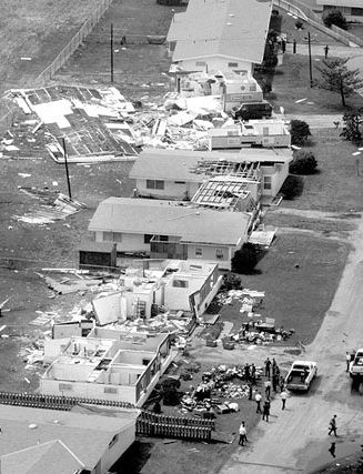 A tornado spawned by Hurricane Emily is thought to have caused this damage to U.S. Coast Guard housing in Buxton. Photo: Island Free Press |
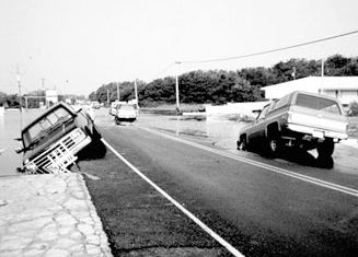 Vehicles fell into sinkholes along N.C. 12 in Buxton after Hurricane Emily. Photo: Island Free Press |
Hurricane Emily was not a really impressive storm as it moved through the Atlantic Ocean on a path that would take it very close to Hatteras Island.
Supporter Spotlight
The tropical wave that spawned Emily moved off the West Coast of Africa on Aug. 17, 1993, and into the Cape Verde Islands. After briefly becoming a hurricane on Aug. 26, the storm fluctuated in intensity between a hurricane and a tropical storm as it moved west-northwest. Intensification continued and by the time Emily came within 13 miles of Cape Hatteras on Aug. 31, it had become a Category 3 storm.
Luckily for the Outer Banks, the hurricane veered north just offshore of Hatteras, but the southern part of the island was in Emily’s western eyewall for an hour and a half. This caused a terrific and destructive storm surge from the Pamlico Sound.
Wally DeMaurice, who was then director of the Weather Service office in Buxton, said the storm surge in Avon, Buxton, Frisco and Hatteras was the highest in living memory. At more than 10 feet, the surge, he said, was higher than in the hurricanes of 1933 and 1944 – and probably the highest since an 1846 storm opened Oregon and Hatteras inlets.
The wind instruments at the Weather Service office stopped functioning about 6 p.m. when flood waters from the Pamlico Sound got telephone lines wet. The highest gust measured at the office before that time was 98 mph.
A wind gauge at Fox Watersports in Buxton, which DeMaurice said was “very reliable,” measured a gust of 107 at 6:12 p.m. The winds at the Diamond Shoals tower, which was very close to the eye, were clocked at 142.
DeMaurice said he was “sweating buckshot” until Emily’s gaping eye, headed straight for Cape Hatteras, made a turn to the north, just a few miles off the coast. If the hurricane had passed over the island and turned north up the sound, he emphasized, the devastation would have been unbelievably worse.
The devastation on the lower part of the island, he noted, was because of the duration of the storm. While Gloria in 1985 moved over Hatteras at 28 mph, Emily poked along at eight to 13 miles per hour. The persistent northwest winds drove a storm surge from the Pamlico Sound over the island up to 10.5 feet in places.
The storm surge brought up to five feet of water into the homes of island residents from Avon through Buxton and on to Frisco and Hatteras villages. Dare County officials later estimated the damage at $12.6 million, but most of it was limited to a 17-mile stretch of the island.
Early damage estimates indicated that 683 primary homes of residents were affected by the storm. That included 168 homes destroyed, 216 uninhabitable because of major damage, and 144 uninhabitable because of minor damage. It was estimated that 25 percent of the year-round, single-family homes were destroyed or uninhabitable.
There were no deaths and only one reported injury during the storm, but Emily brought devastating personal tragedy to the islanders.
Connie Farrow was living on Lester Farrow Road in Frisco during Hurricane Emily. She and her toddler daughter, Tiffany, decided to stay with her brother for the duration of the storm in his two-story house. As they were preparing to leave, a neighbor stopped by and commented, “Shouldn’t you get some of these things up higher?”
“I have lived in this area for most of 30 years,” Connie said. “We have never had tide in the houses.” She later returned home to 18 inches of standing water and numerous ruined photographs, clothes, toys, and other possessions.
While they were staying with her brother, water began flooding the downstairs of the house, forcing them to climb to the second floor. Tiffany kept running to the doorway to watch the water creep up the stairs. With a child’s innocence, she joyfully announced, “I’m going swimming!”
Edie Coulter and her husband, “Creature,” were under their house in Frisco, attempting to secure a few things when they saw the tide beginning to rise at the corner of their yard. They decided to disconnect their propane tanks, but within minutes the water was up to their waists and climbing higher. As they struggled with the tanks, Edie says they were pelted with pine cones shaken from the trees in the wind and rain.
They had previously parked their John Deere lawn tractor on top of their septic tank since that spot was the highest point in their yard. “We stood at the upstairs window and watched the water rise right up over that old John Deere,” Edie remembers. “There was just water everywhere. So much water. Water as far as the eye could see.”
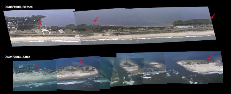
These before and after composite photos compiled by the U.S. Geological Survey show the section of Hatteras Island that was punched through by Hurricane Isabel. Photo: USGS
Hurricane Isabel
Unlike Emily, Isabel was a monster of a storm as it moved across the Atlantic toward its rendezvous with Hatteras village on Sept. 18, 2003.
Hurricane Isabel began as a strong tropical wave off the coast of Africa in early September. It became a tropical depression and then was christened Tropical Storm Isabel on Sept. 6. By the next day, it was a minimal hurricane, but it rapidly progressed up the Saffir-Simpson scale. A day later, on Sept. 8, Isabel was a Category 4 with winds of 135 mph. The winds kept going up and on Sept. 11, it became a Category 5 with winds measuring 160 mph. It maintained that strength for the better part of three days, but then started to weaken.
Isabel was downgraded to a Category 2 on Sept. 16 and stayed there until it made landfall two days later near Drum Inlet in Carteret County around 1 p.m. The storm moved northwest to Roanoke Rapids by 5 p.m. and accelerated to northeast West Virginia by 5 a.m. Sept. 19 as a tropical storm. Its remnants eventually moved northward into Canada.
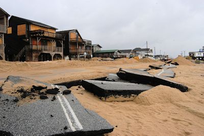 N.C. 12 though Kill Devil Hills is a jumbled mess after Hurricane Isabel. Photo: Mark Wolf, FEMA |
The wave energy that built up as the storm churned over the ocean as a Category 4 and 5 sealed the fate of Hatteras village.
“When it was a Category 5, it generated very high surf,” Dr. Steve Lyons, who in 2003 was the Weather Channel’s tropical weather expert, said in an interview the week after the storm. “The high surf continued to move on shore and made the wave action on landfall much larger than would have been expected in a Category 2 storm.”
Lyons and others note that Hatteras village was in the right front quadrant of the storm as it came ashore to the south. That’s the area that can expect the worst weather — the highest winds, waves, and storm surge. Hatteras, Lyons said, had “the highest waves of any on the East Coast.”
He added that Isabel was a Category 2 storm in terms of its winds and storm surge, but he said it was a Category 5 for wave action.
Gene “Iceman” Chiellini, who in 2003 was a hydrometeorological technician at the Newport weather office, is even more emphatic that wave energy was the most destructive force in Isabel.
“Isabel, the Category 2 storm, didn’t do that damage that you see,” he said. “The winds didn’t do this. They did some of the damage. But most of the damage you see was done by wave action.”
Marine forecasts just before the storms predicted wave heights of 30 to 35 feet, but Chiellini, an avid surfer with 27 years’ experience with the Weather Service, felt that estimate was conservative.
On the afternoon and evening of Sept. 17, the day before Isabel hit the coast, Chiellini said the NOAA buoy at Diamond Shoals, about 15 miles off Cape Hatteras, was registering waves of 16 to 18 feet. By 9 p.m., the wave height was up to 21 feet. At 2 a.m. it was 27 feet, and then an hour later, at 3 a.m., the buoy registered a 44.6-foot wave and stopped reporting. He presumes the buoy has been blown to parts unknown.
Chiellini says the Weather Service estimates that the storm surge was 6 to 8 feet with 15- to 20-foot waves breaking onshore in Hatteras village. That would have put the wall of water with tremendous energy hitting the shoreline in the range of 21 to 28 feet. Lyons at the Weather Channel put the height at 20 to 26 feet.
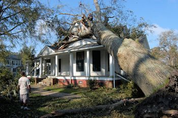 A tree came down on a historic house in Edenton. Photo: Mark Wolfe, FEMA |
The immense power of the storm surge plus the wave energy was apparent in Hatteras village. Motels along the beach were destroyed, with buildings moved into or across N.C. 12. Buildings, such as the Hatteras Cabanas, were moved across the highway and into the marsh. Other buildings were washed off their pilings. Houses sat in sink holes with only a few feet of the top floor and the roofs above water. One house was washed out into the Pamlico Sound. Buildings stood with only side cinder-block walls, the front and back walls blown out by the wave energy and the building swept clean of furnishings. Cars and trucks were flipped and crushed, and many feet of sand filled the lower floors of many buildings.
Although most of Hatteras Island did not have soundside flooding, as it does in most hurricanes, even homes in Hatteras village that were not on the oceanfront were not immune from damage. The surge with the waves on top washed over the eastern end of the village and into the sound near Sandy Bay. The east wind blew the water around the back of the village and in through the creeks that run through it. Homes were flooded, and debris from the oceanfront — refrigerators, air conditioners, beds, dressers, motel room doors with the numbers still on them — lined the back creeks into the village.
Isabel would become the deadliest and costliest storm of the 2003 hurricane season. It produced moderate to heavy damage across eastern North Carolina, totaling $450 million. Damage was heaviest in Dare County, where storm surge flooding and strong winds damaged thousands of houses. The storm surge cut a 2,000-foot wide inlet on Hatteras Island, unofficially known as Isabel Inlet, isolating Hatteras by road for two months.
Strong winds downed hundreds of trees of across the state, leaving up to 700,000 residents without power. Most areas with power outages had power restored within a few days.
The hurricane directly killed one person and indirectly killed two in the state.


