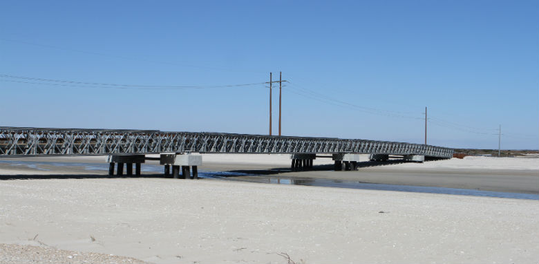
 The temporary bridge spanning NC 12. Photo: Sam Bland
First of a two-part series
RODANTHE– Leave the bustle and bedlam of summer traffic on the northern Outer Banks and take a drive south on N.C. 12, probably the most written-about and ever-changing road on the East Coast. Get a glimpse of climate change at work and peek into the future of North Carolina’s barrier islands.
Supporter Spotlight
Start at Whalebone Junction in Nags Head and head south. The beach expands, the salt marsh appears and the unbroken line of beachfront homes gradually subsides. The next 25 miles encompass the most dynamic stretch of roadway in North Carolina.
Before crossing over Oregon Inlet to Pea Island, a stop at Oregon Inlet Fishing Center is elemental to the trip south. Built in 1953, the marina is the center of the local sportfishing industry. During the summer months, the marina’s docks are animated with one of the greatest traditions in the region – swapping fishing truths and tales. Enjoy the center’s famous hot dogs and observe one of the best recreational fishing fleets in the world heave their day’s catch from boat to dock.
Turn right out of the fishing center and cross the 2.5-mile-long Herbert C. Bonner Bridge over Oregon Inlet. The inlet and the bridge are key chapters in the N.C. 12 story. To know why, you need to understand just one thing: The inlet moves and the bridge does not.
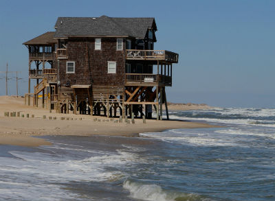 This house at the S-curves in Rodanthe demonstrates the precariousness of life on a moving island. Photo: Sam Bland |
As do other inlets along the N.C. coast, Oregon Inlet has steadily crept southward. Scientists estimate it has moved two miles since it opened in a storm in 1846. If you could walk across the fishing catwalks on the side of the bridge, you’d notice that much of the catwalk on the northern end of the bridge now spans dry land. It didn’t when the bridge opened in 1963.
The moving inlet has been more than just an inconvenience to fishermen. To ensure safe passage to the sea, the boat channel through the inlet must pass under the bridge’s highest spans. That hasn’t been easy since the inlet moves and the bridge doesn’t. The state has had to constantly dredge the channel to keep it in place and deep enough for the commercial fishing boats that use it. The job has become increasingly more difficult and expensive in recent years. One reason is that the sea is rising faster than it has in the past because of global warming.
Supporter Spotlight
Stop at the Pea Island National Wildlife Refuge at the south end of the bridge to stand on the other reason. The refuge is known for its crystal waters and vibrant bird populations. But walk out to the beach and you can stand on the big rock wall that the state built in the early 1990s to protect the southern approach to the Bonner Bridge. The so-called terminal groin did its job and kept the land here from migrating away from the bridge. But the island on the other side of the inlet keeps coming south, squeezing the channel and making the difficult job of keeping it in place almost impossible.
Maybe this will all be solved when the state builds a new bridge across the inlet. The debate about where to put the replacement bridge has raged for several years now. Some environmental groups and scientists urged the state to avoid the inlet altogether and build a causeway into Pamlico Sound to connect the two islands. The state opted instead to build the new bridge about where the current one sits. The environmental groups sued, and the courts will decide the matter, though bridge construction is scheduled to begin next year.
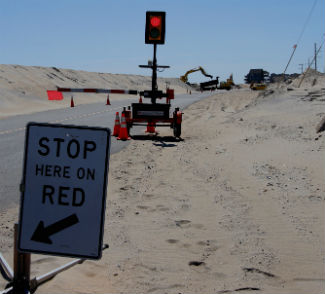 Construction equipment is now a seemingly permanent part of the landscape on NC12. Photo: Sam Bland |
Driving south through Pea Island you can’t help but notice the new “normal” of N.C. 12. Bright yellow bulldozers sling sand that the ocean dumps on the abused roadway with every storm tide, while lines of dump trucks transport load after load to build dunes in a herculean effort to halt the encroaching ocean. Rows of sand bags, some as big as houses, hold power poles in place at Mirlo Beach, while a piecemeal bridge supports traffic at the “new” New Inlet that Hurricane Irene cut a couple a years ago. This is now the new standard as the state battles to keep the road open in the face of a rising sea.
While the tenuous system will continue to flounder in the face of the next coastal storm, the beaches lining N.C. 12 are worth the extra look. Stand beneath the temporary bridge of the “new” New Inlet, or float from sound to ocean. Count the paces from Mirlo Beach’s sandbags to the ocean’s edge, or name the drab houses pasted with condemnation notices, tottering precariously over the surf, as if one pin prick would send them reeling to the sea.
The fragility of the system is unmatched. Sure, it may not have been what you had in mind, but I’ll bet you’ll remember exploration of these oddities better than that nap on the beach. Crystal clear waters and sweltering beach days will most likely always be a part of Outer Banks summers. Will N.C. 12?
Part Two, Thursday, June 13: A Walk on the Beach at Pea Island


