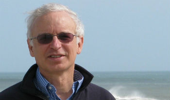
 Bill Birkemeier arrived in Duck as a 29-year-old engineer, never intending to stay for long. He retired 32 years later as the esteemed head of one of the most respected centers of coastal research in the world. Photo: Bill Birkemeier |
DUCK — Bill Birkemeier is not one to brag, but he’s got to feel good about his nearly four-decade career with the Army Corps of Engineers, the bulk of which was spent overseeing the Duck Field Research Facility, a cauldron of cutting-edge coastal research that has single-handedly changed the understanding of beaches for the entire world.
Suffice it to say that Birkemeier, who retired last month, never expected how satisfied he would feel at age 62, looking back 32 years on a job spent just where he started and still living in the house where his children were raised.
Supporter Spotlight
“I never thought I’d come here at the age of 29 and retire at the same place,” he said during a recent interview in his living room at his Southern Shores home, jazz playing in the background.
Tall and lean, Birkemeier has a persona that young folks would call “chill.” He walks with a relaxed, long-legged lope, has an easy grin and laughs readily. He responds to the most inane questions with no condescension, patiently breaking dense scientific concepts into digestible bits. When he speaks to non-scientists, he can make arcane coastal engineering concepts sound like fascinating feats.
But the affable coastal engineer is also highly regarded by his peers within the national and international coastal science community.
 Orrin Pillkey |
“To me, he’s the good guy. He’s the good part of the Corps,” said Orrin Pilkey, a Duke University coastal geologist and longstanding critic of the Corps. “When we’d go to Duck pier, he’d always lead the way. He was very generous with his time.
“He’s really a very respected guy. I don’t think of him as an engineer. I think of him as a scientist,” Pilkey said. “He’s wonderful. He’s a real gem.”
Supporter Spotlight
Built in 1977, the Duck Pier, as it’s known informally, was established to provide a way to study coastal processes near the shore, which at the time had been barely researched. Situated on the ocean beach and accessible to breaking waves, the 1,840-foot concrete pier, its cement-filled steel pipe pilings driven 50 feet into the sand, provided an ideal location to conduct research.
Birkemeier, who grew up in Connecticut, had earned his masters degree in coastal engineering from the University of Delaware — “I was always intrigued with the ocean,” he said — and had found a job with the Corps in Washington where he worked as a coastal researcher for five years. Then he heard about an opening at the Duck Pier.
“I thought, ‘Mmmm, if you’re going to be a coastal engineer, you should live at the coast,’” he recalled.
Soon, he and his wife, Peggy, and their then-3-year-old daughter, Sara, moved to a lovely tree-lined neighborhood in Southern Shores, a few miles away from the pier. A younger daughter, Emily, was born six years later. At the time, there was no town water, no grocery store and the paved road stopped just north of the Duck Pier. But the family quickly made themselves at home.
“It’s interesting, I think you lock-in — fall in love is another way of saying it — with the Outer Banks the way it was the year you arrived,” Birkemeier said, sidestepping nostalgic ruminations about the good ol’ days. “We felt very remote, but like I say, you lock-in.”
Initially, he was working as one of a small group of engineers and scientists studying the impacts of storms on the beaches. Various gauges and instruments were suspended off the pier or attached on top, an ocean buoy provided information about waves, tides and currents, and eventually a camera was set up to constantly record the near shore beach north of the pier.
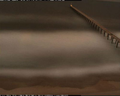 This ghostly, time-lapse photograph of the pier at the Duck Field Research Facility was taken yesterday at 5 p.m. Photo: Army Corps of Engineers |
The research started getting real interesting when the Coastal Research Amphibious Buggy arrived in 1981, still one of only two in the world. A motorized 35-foot tall tripod, the CRAB, unlike a research boat, could map the ocean floor without being affected by motion from waves or currents. Thanks to its ability to operate in up to 30 feet of calm water and in breaking waves, the CRAB amassed data that recorded sandbar movement and bottom changes. For the first time the pier’s equipment was able to observe and measure sand movement on and off the beach, and the changes could be mapped.
“There just wasn’t any data,” Birkemeier said about the early days. “A little bit here and a little bit there — no comprehensive sampling or measurements during storms. Most of the cool data was from the CRAB.”
In 1987, Birkemeier was named director of the facility. By the time he retired, he was the pier’s liason to Washington. But whatever his title, he was the face of the pier to the Outer Banks and the entire coastal research community.
Kent Hathaway, a research oceanographer at the pier since 1985, said that he first regarded the job as a jumping-off point for his career. But he soon found both the work and his boss too good to leave.
“Bill was just the most even-tempered, together guy to work for,” he said. “He was an amazing boss.”
Easy-going as he was, Birkemeier still kept the 10-person team (now there are 12) focused on the “vision” to collect long-term climate data sets. It was Birkemeier who wrote the software development that corrected for boat motion in the data, and who processed the data that was collected, as well as maintaining his duties as branch chief.
“Bill’s been instrumental in keeping that mission,” Hathaway said about surveying. “He always kept us in the forefront.”
But Birkemeier was never big-headed or too busy to encourage budding scientists, Hathaway said.
“We’ve had so many good students come through here, and when we hear from them,” he said, “they’d say it was one of their greatest experiences.”
The Duck ’85 and Sandy Duck experiments, which included extensive study of waves, currents and sediment transport by many academic scientists and researchers, really put the Corps on the map. The projects garnered international news coverage in newspapers, magazines and television. And the pier has since stayed on media radar screens. In 2005, for instance, Birkemeier and the work at the pier were covered in the National Geographic News and on NPR.
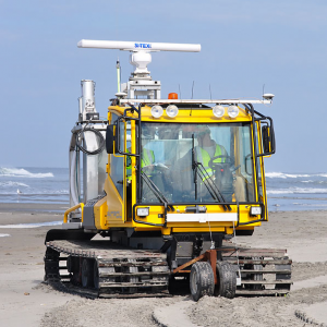 Called CLARIS for Coasal Lidar and Radar Imaging System, this machine looks like a tractor cab set on tank tracks. Its lasers and radar help scientists at the Duck Pier better predict beach erosion. Photo: Army Corps of Engineers |
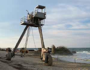 This is the famous CRAB — for Coastal Research Amphibious Buggy. It arrived in Duck in 1981 and changed our understanding of the natural forces close to shore. Photo: Outer Banks Voice |
“It’s still the place to come for coastal studies,” Hathaway said. “We’ve got the cool toys. When you go to international meetings to discuss coastal research, everybody’s presenting their stuff and half of them are using data from here.”
Thanks in part to experiments done at the pier, more and more coastal data is being collected worldwide, Hathaway said, but the pier has the best long-term data set on waves.
Hathaway said that it has barely sunk in that with Birkemeier’s retirement, “a wealth of knowledge is walking out the door.”
“Bill, he’d remember what everybody was doing,” he said. “He’d look at a slide and see an instrument and say, ‘Yeah, that’s so-and-so’s gauge.’”
With increasingly sophisticated technology being created on a steady basis, research and the computer models used at the pier have become much more complex. Additional gauges that measure waves and currents have been installed offshore, allowing waves to be measured from the shelf break to the beach. There is also remote sensing data collected from lasers and radar attached to a vehicle that drives up and down the beach.
Today, the data collected at the pier are available online to anyone — although a science background is necessary to decipher it. But local weather junkies and surfers routinely log on to the pier Web site to get information on tides, temperature and wave heights.
“In our history, the measurements that have been done and the research that has been done has totally changed our understanding of the near shore,” Birkemeier said. “It applies to a lot of the coast, too.
Picking up his laptop computer he had stashed nearby, Birkemeier showed off one of the dazzling tools developed to illustrate the data: a “movie” of the beach moving over a period of months.
“See the sand coming onshore?” he said, pointing to the shadowy line moving underwater toward the shoreline. “People didn’t understand the accretion process. Most of the time the beach is building.”
The pier’s research not only disproved a previous theory that the current was strongest on the sandbar, Birkemeier said, it showed that there was actually little current over the bar. That’s just one reason he often cautioned his cohorts to “let the data talk.”
Birkemeier said he’ll help out at the pier on a part-time basis, but he said he’s got plenty to do to keep himself busy, including his successful photography business, “In the Lens.”
The pier will continue to work cooperatively on coastal research programs with numerous state and federal agencies and academic scientists and researchers from around the world. Increasing concerns about sea-level rise and climate change have raised new questions for coastal scientists and engineers. Many of their answers will be based on data from the Duck Pier.
Pilkey said that the pier is not only a unique resource for coastal science worldwide, it may be the best pier on the East Coast for looking at sea-level rise.
“It’s so intermeshed with our understanding of beaches,” Pilkey said. “Everybody who studied beaches has benefited from the work that was done under Bill Birkemeier’s tutelage.”


