Reprinted from the Outer Banks Voice
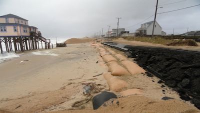
 Sandy flattened sand dunes in Kitty Hawk. Photo: N.C. Department of Transportation. |
NAGS HEAD — Two years ago, Hurricane Sandy would have been big news in South Nags Head.
For years, the narrow shoreline from Jennette’s Pier south to the National Park Service border took a pounding from winter storms and tropical systems.
Supporter Spotlight
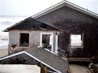
Left behind were pitiful images of half-collapsed houses and a beach strewn with broken septic tanks, twisted pipes and pieces of decks and stairs. Dozens of houses were routinely condemned as uninhabitable until repairs were made.
The scenes were perfect for a television news standup.
But after Sandy raked Outer Banks beaches for three days at the end of last month, South Nags Head was little more than a footnote. Last year’s $36 million project to widen 10 miles of the Nags Head shoreline did its job. This time, at least. Still, the results were good enough to warrant some bragging.
Critics had to stretch to make a case that nourishment wasn’t working. Renee Cahoon, a Nags Head commissioner, noted the difference between photos during the storm, which showed heavy surf to the dune line, and those after Sandy revealing a wide, flat beach.
“I’d like to remind everybody that blogs represent opinions, not facts,” she said at a recent Board of Commissioners meeting. “And that contrary to what goes out, the beach was never meant to stop the water. The beach was meant to absorb the impacts of the ocean before it damaged all the structures behind it.”
Supporter Spotlight
Contrasts can also be seen in the numbers. After Sandy, repairs to Nags Head beach accesses cost $93, town officials said. After Hurricane Isabel in 2003, damage to Nags Head accesses amounted to $300,000 to $400,000.

Images like this one after 2009′s hybrid storm like Sandy at the same time of year were typical of South Nags Head. Photo: Outer Banks Voice. |
Overall, damage to homes throughout the town after Sandy added up to about $413,000, Elizabeth Teague, the town’s Planning and Development director, said. All of it was minor — mostly water in ground-floor enclosures.
Commercial damage was estimated at $202,000 to 11 properties. The only major damage — about $30,000 worth — was next door to the Nags Head Fishing Pier, where the surf blew out a bulkhead and a patio collapsed.
“Considering what happened in other places, we did very well in terms of damage,” Teague said.
Kitty Hawk is still mopping up after Sandy’s surf flattened a dune line north of the Black Pelican restaurant, sending water two blocks west and across U.S. 158. The section of U.S. 158 was closed for two days, and N.C. 12, the beach road, was buried in sand with asphalt in some places left crumbling.
Town Manager John Stockton said Kitty Hawk saw $63,500 in commercial damage and $1,608,800 in residential damage.
Houses in Kitty Hawk have been removed from the beach over the years, and a weak point — where the waves found an opening — appears to be near the one that remains. The town might qualify for beach re-nourishment funds from the county to buy and remove the house, but so far the owner is not ready to negotiate, Stockton said.
Beach re-nourishment is not under consideration right now. Most of the damage in recent years has been to N.C. 12, which the N.C. Department of Transportation maintains. The weak section of the beach appeared to have gained some width during the storm, but the dune line was unable to hold the surf back, Stockton said.
Meanwhile, Kill Devill Hills is still considering a two-mile widening project.
A Nags Head maintenance plan submitted to FEMA calls for re-nourishing the beach after five years or a 50 percent loss of new sand, whichever comes later. So the real test will be how the beach holds up over at least five years.
After Hurricane Irene in August 2011, measurements showed that about half the visible sand from the project was underwater but still within the system. FEMA considers sand offshore to a depth of 19 feet part of the system.
Coastal Science and Engineering, the town’s consultant, is putting together a new survey of the beach to see how it has fared. Town Manager Cliff Ogburn said that judging from the accumulation of sand along fencing, it appears that 2 to 3 feet of elevation have been added at the base of the dune line.


