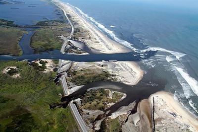
 Hurricane Irene cut two inlets in the Pea Island National Wildlife Refuge on Hatteras Island. Photo: U.S. Fish & Wildlife Service Hurricane Irene cut two inlets in the Pea Island National Wildlife Refuge on Hatteras Island. Photo: U.S. Fish & Wildlife Service |
HATTERAS — Traveling along the edge of the continent on a two-lane highway built atop a skinny strand of shifting sand just inches above two mighty bodies of water might sound adventuresome in travel guides.
The adventure can turn hazardous on a nasty day in the Pea Island National Wildlife Refuge. Sand swirls in angry gusts across the road, vast pools of water — from sky, ocean, sound or all of the above — force vehicles to crawl, turn around or stall. Dunes appear to transform into living things, buffeting a pitiful strip of asphalt from monstrous waves.
Supporter Spotlight
But for residents of the Outer Banks, driving on the 65-miles of N.C. 12 on Hatteras and Ocracoke islands is an economic necessity and a transportation challenge. Tourism brought $834 million into Dare County in 2010, and most islanders make their living from tourist-related business.
Two severe cuts in the road in and on the south edge of the refuge inflicted by Hurricane Irene in August were the most recent illustration of the corridor’s vulnerability to beach erosion and storm damage, renewing questions about the futility of fixing such a vulnerable highway, especially in an era of a rapidly rising sea.
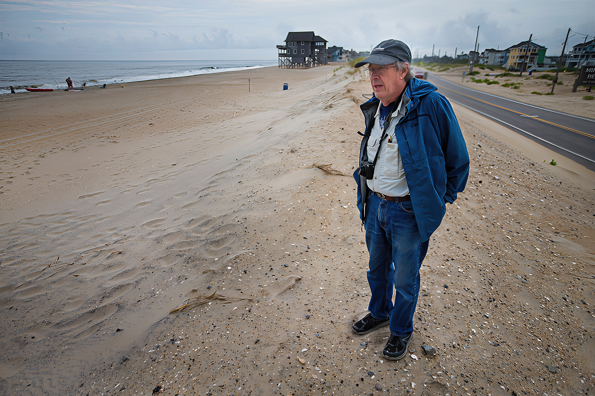
“The cost of maintaining Pea Island has been incredibly expensive,” said Stan Riggs, a geology professor at East Carolina University. “If the public knew how much has been spent just to hold that road, I think they’d croak.”
 Dr. Stanley Riggs |
Riggs has spent his professional life researching the natural dynamics of the N.C. coast. Few people know more about the coast’s geology. Riggs has written numerous books on coastal geology, including The Battle for North Carolina’s Coast. The recently published book argues that the present development and management policies for the coast’s changing barrier island are in direct conflict with their natural dynamics.
Riggs agrees that a transportation route for Hatteras Island is a necessity. But sea level rise is expected to accelerate in the future because of a changing climate, he says. That means only worse problems for N.C. 12, Riggs noted. It’s time, he said, for people to get creative.
Supporter Spotlight
“We need a whole new paradigm,” he said.
How High Will She Rise
Oceans rise in a warming climate. Water expands as it heats up, and melting glaciers add to the oceans’ volume.
That much scientists know. How high the sea might rise in the future and how quickly are still open to debate. That will depend largely on how much of the Greenland and Antarctic ice caps melt.
Because of its gently sloping coastline, North Carolina is one of the most vulnerable states on the East Coast to sea-level rise, scientists say. Most current scientific estimates put the Atlantic Ocean along our shores about three feet higher than it is now by 2100. That’s about double the historic rate of sea-level rise. A panel of scientific experts that advises the state’s Coastal Resources Commission came to a similar conclusion last year in its original draft report on future sea-level rise. It concluded that the rise would be about 39 inches by 2100. Depending on how much or how little is done to address climate change, the rate could potentially be as low as 18 inches per 100 years, or as high as 55 inches.
A follow-up draft was watered down significantly after intense lobbying by development interests. The commission is awaiting a response from its scientific panel before deciding on a final report.
As policymakers ponder, the ocean continues its inexorable rise, putting that thin ribbon of asphalt known as N.C. 12 in greater jeopardy and its future in greater question.
“We’re not opposed to doing something out there,” Riggs said. “Our point is, we know what the science is.”
Along Comes Irene
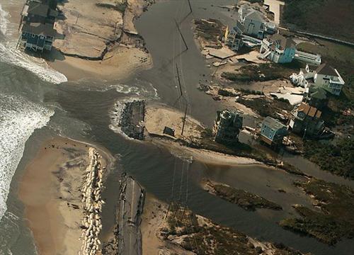 Hurricane Irene chewed up N.C. 12 through Mirlo Beach. Photo: Outer Banks Voice |
At one breach in Pea Island, about six miles south of Oregon Inlet, Hurricane Irene cut about 150 feet from the road, channeling surging water from ocean to sound. Further south at Mirlo Beach, she destroyed whole sections of roadbed with a surging tide.
Riggs has long predicted that those areas, especially at Mirlo, could become new inlets, but Irene was a weak hurricane that barely kicked up wave. Even weak storms, scientist warn, can have catastrophic effects as the oceans warm and rise.
“It was all on the backside, and those inlets blew out, not in,” Riggs said. “And all that destruction was because the water couldn’t get out.”
With the blessing of Gov. Bev Perdue, the N.C. Department of Transportation went into high gear to get the road reopened to traffic. Emergency ferries transported supply vehicles, utility trucks and, eventually, some of stranded residents back and forth between Stumpy Point and Rodanthe.
Within weeks, a temporary, $2.6 million steel truss bridge was installed over the breach in Pea Island, and road workers repaired the underbed and repaved N.C. 12 at Mirlo Beach. The highway reopened Oct. 5, but DOT already has had to reinforce the new inlet’s south shore with rock and metal sheet piling to stem erosion that could have undermined the bridge.
Long-term solutions at the north end at Mirlo, where erosion is as much as 15 feet a year, include building a bridge within the easement and building a bridge that extends into the Pamlico Sound. At the Pea Island inlet, options are to build a new road or bridge west of the existing road, or build a permanent bridge where the road now stands.
Permanent fixes proposed by DOT at both sites initially included beach nourishment, either by itself or combined with bridging, But after a December meeting of state and federal agency representatives, DOT decided it was not a viable option because offshore sand sources were inadequate, it was too costly and permits would be difficult, if not impossible, to obtain.
At the suggestion of the U.S. Fish and Wildlife Service manager of the refuge, DOT agreed at the December meeting to look into the feasibility of a longer, seven-mile bridge that would start north of the Pea Island breach, curve out into Pamlico Sound and tie-in at Rodanthe.
Public comment on the proposals closed in January, and DOT is expected to make a recommendation on an alternative within weeks.
Maintaining the Road
Whatever the choice, DOT remains committed to keeping the coastal thoroughfare open.
“N.C. 12 is just like any of our highways that has its own challenges,” said Victor Barbour, DOT’s technical services administrator. “But I do think from an overall perspective, we have some roads in the mountains that cost as much or more as N.C. 12 to maintain.”
According to information in the final environmental impact statement for replacing the aging Herbert C. Bonner Bridge at Oregon Inlet, DOT spent about $5.5 million to restore N.C. 12 after storms between August 1999 and October 2007. Of that, about $3.9 million was spent within the Pea Island refuge at three “hot spots, ” including at ‘S’ Curves, renowned as a premier East Coast surfing spot. Most of the costs were related to Hurricanes Dennis, Bonnie and Floyd in 1999 ($1.7 million) and Hurricane Isabel in 2003 ($1.2 million). Over that period, there were six hurricanes, one tropical storm and 13 nor’easters that required clean-ups.But Barbour agreed that maintenance of N.C. 12 is more expensive than an average road. Over the last 10 years, he said, DOT has spent $100 million maintaining 120 miles of N.C. 12 stretching from Corolla to Ocracoke. Although the cost has not been broken out per mile, there’s no doubt that the vast majority of work is concentrated south of Oregon Inlet. So far, Barbour said, Hurricane Irene damage has cost $12 million, much of it paid by federal emergency funds.
Pea Island, the Bonner Bridge
Pea Island National Wildlife Refuge has some of the most pristine beaches on Outer Banks. Not only do residents love to go there, it attracts about 3 million visitors per year. But it’s not a substantial land— just 13 miles long, the refuge is at its widest only one mile east to west. At its narrowest, it is just a quarter mile across.
In the old days, the ebb and flow of the tide was unrestricted. Now, Riggs said, “the whole system is in danger of being blown out.”
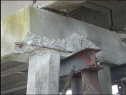 Crumbling supports at the Herbert C. Bonner Bridge. |
Environmental groups and the U.S. Fish and Wildlife Service, which runs the refuge, favored a 17.5-mile bridge to replace the aging Herbert C. Bonner Bridge over Oregon Inlet that would have bypassed Pea Island and its troublesome hot spots. DOT took the proposal off the table because of its high upfront cost and access issues. Construction of the new bridge just west of the existing one is scheduled to begin in early 2013.
Dennis Stewart, a refuge biologist who is a member of a N.C. 12 coastal scientist panel that has advised DOT, said that Fish and Wildlife is working cooperatively with DOT to find mutually acceptable fixes to N.C. 12. Although Mirlo is mostly outside of the refuge, the hot spot area stretches from ‘S-Curves’ on the south end of the refuge into Rodanthe.
Stewart said he has seen Pea Island narrow over the years. When he first started in 1994, N.C. 12 was located east of a ranger’s building, a 40-vehicle parking lot was east of the highway and a double dune line was east of the lot. All that’s gone now, he said.
The water that came rushing back toward the sound shoreline when Irene passed turned out to be a powerful punch at a weak spot.
“It was almost like a tsunami,” Stewart said. “Hurricane Irene totally convinced me that it’s a fragile system.”
As a coastal engineer with North Carolina Sea Grant, Spencer Rogers —who is also a member of the N.C. 12 coastal panel — said that despite the overall success of road relocation in the past, Fish and Wildlife will no longer permit that remedy. Another challenge to maintaining the corridor in the future, he said, is the near-impossibility of fixing the road within the 100-foot state right of way, as required by the refuge.
Andrew Coburn, associate director of the Program for the Study of Developed Shorelines at Western Carolina University, said that it all boils down to allocation of sparse resources
“If there’s an unlimited amount of sand and an unlimited amount of money, absolutely you can keep a road open there,” he said. “If you had unlimited resources, you probably wouldn’t have had a breach. But you’d have to deal with the potential environmental impacts of what you did to maintain that road.
“It’s tough,” Coburn said. “It’s almost an impossible situation to be in.”
Riggs, convinced that there will be little other option in the not -too-distant future, supports use of high-tech ferries – an idea that is anathema to Dare County and one DOT says would be impractical– combined with things like water taxis or float planes that have been used successfully in other coastal regions.
“Right now, we’ve survived just out of sheer luck,” Riggs said “The next big storm is going to be a catastrophe.”
Coming in March: What will the Outer Banks look like?


