The National Park Service has approved a project to stabilize about a mile of rapidly eroding shoreline at Fort Raleigh National Historic Site.
The 513-acre site located on the northern end of Roanoke Island in the Albemarle Sound was established in 1941 to preserve where Sir Walter Raleigh established colonial settlements between 1581 and 1591.
Supporter Spotlight

National Park Service leadership signed on Jan. 14 a finding of no significant impact to install a combination of rock revetment and rock berm to sections of the shoreline. A finding of no significant impact confirms that a proposed action won’t significantly affect the environment.
When the National Park Service announced the project’s approval Jan. 15, officials also released the mandatory floodplain statement of findings, which explains why the project must take place in a floodplain, along with any associated risk, and flood mitigation strategies.
The announcement opened up a two-week comment period that ends Friday on the findings. Instructions on how to comment are on National Park Service’s website.
The floodplain statement of findings concludes that the proposed rock revetment and berm to prevent ongoing and future shoreline erosion at Fort Raleigh National Historic Site “is necessary and consistent” with federal rules on activities in floodplains.
On the same day, the North Carolina Department of Environmental Quality’s Division of Coastal Management announced and opened up a public comment period for the National Oceanic and Atmospheric Administration-requested federal consistency determination for the proposed rock berm and revetment combination project.
Supporter Spotlight

The determination is to “ensure compliance” with the Coastal Zone Management Act, a national policy for managing coastal resources.
“Specifically, the National Park Service proposes installing rock berms and rock revetments along approximately 1,100 linear feet of shoreline on the western end of Roanoke Island to reduce erosion, protect infrastructure, and enhance long-term shoreline stability,” per the state. “The State’s review of the submitted federal consistency determination request will determine if the proposed project in Dare County is consistent with the enforceable policies of North Carolina’s Coastal Management Program.”
To read the shoreline stabilization federal consistency determination request and comment, visit NCDEQ’s website.
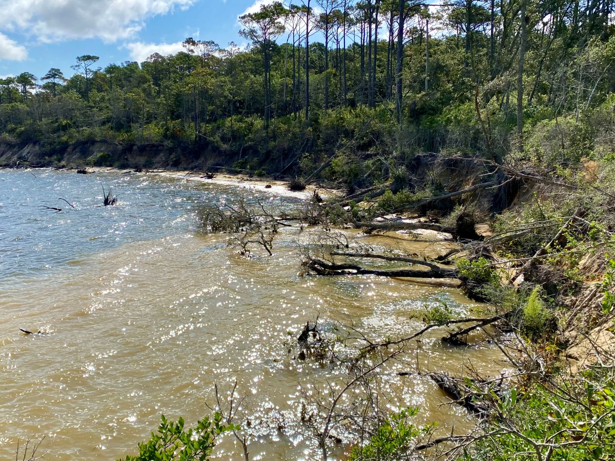
Since becoming a national historic site, erosion along the property’s shoreline has been a management challenge. The shoreline is estimated to have eroded a quarter-mile or more since the late 16th century, according to the National Park Service.
Previous efforts have been made to slow shoreline loss but erosion has continued at an estimated 1 to 5 feet per year, impacting both cultural and natural resources at the site as well as the adjacent, privately owned Elizabethan Gardens, documents explain.
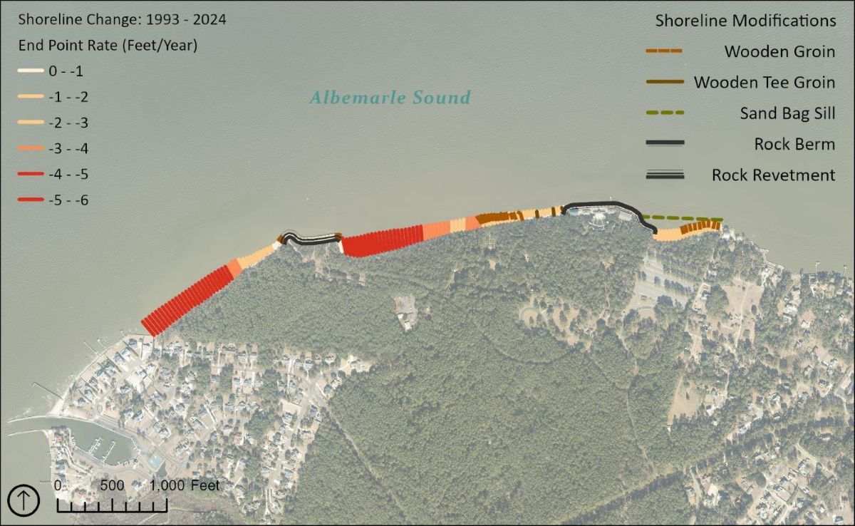
Raleigh National Historic Site and Elizabethan Gardens. Graphic: National Park Service
Michael Flynn is the physical scientist and certified floodplain manager for the Outer Banks Group of National Parks, which consists of Fort Raleigh, Cape Hatteras National Seashore and Wright Brothers National Memorial.
Flynn told Coastal Review that wind, wave action and currents have eroded the shoreline over time and threaten facilities, infrastructure and cultural resources such as the Waterside Theater, where the “Lost Colony” out door drama is performed every summer, and a family cemetery on the property.
“This has caused loss of archeological resources and upland forested areas,” Flynn said. “In the 1980s, the park installed stabilization measures including rock berm and rock revetment. Erosion is especially prevalent at the edges of these stabilization measures in an effect known as flanking.”
In recent years, park staff have been developing the stabilization and erosion control plan approved earlier this month and the associated environmental assessment, which identifies any potential effects of the proposed project.
The plan and environmental assessment released in July 2025 detailed three possible projects: a rock revetment, a rock berm or a combination of the two. The environmental assessment that was out for public review July 21, 2025, to Aug. 20, 2025, identified as the preferred action the combination of the two.
“After evaluating the potential impacts of three action alternatives, NPS selected the preferred alternative: a combination of rock revetment and rock berm in areas of the shoreline that are the best fit due to existing topography, land use and constructability,” according to the press release.
Flynn said the combination was chosen because of the variable topography along the shoreline. The approach also offers flexibility for engineered designs for different environmental conditions.
For example, the rock revetment alternative will be placed in locations where existing steep and high embankments range from 5 to 15 feet or higher, he said.
“For areas with rock revetment, the application of appropriately sized rock will prevent the bluff from sloughing. The rock berm alternative will be placed in areas with no or minimal embankment heights. For areas with rock berm, the application of appropriately sized rock will protect the low-elevation sand beach areas from erosion caused by wave action,” he explained.
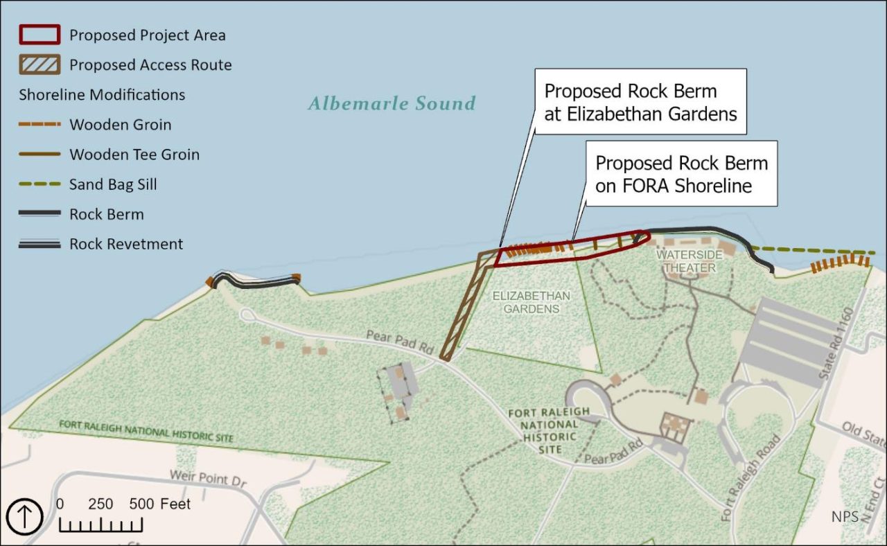
Elizabethan Gardens and a section of the shoreline at the Fort Raleigh National Historic Site, labeled as FORA Shoreline on the map. Graphic: National Park Service
Flynn said that the environmental assessment for the proposed project was prepared in accordance with the National Environmental Policy Act, NEPA, and Department of Interior NEPA regulations.
Because the National Park Service issuing earlier this month the finding of no significant impact, often referred to as a FONSI, officials determined that the preferred alternative identified in the environmental assessment, or EA, will not have a significant effect on the human environment. If the environmental assessment does not support a finding of no significant impact, then the park service must prepare an environmental impact statement and issue a Record of Decision before taking action on the proposed activity.
“In short, Fort Raleigh may now proceed with implementing the preferred alternative described within the EA. The park will stabilize the shoreline for erosion control once NPS officials finalize the accompanying Floodplain Statement of Findings,” Flynn said.
The floodplain statement of findings is necessary because of two executive orders that require the National Park Service to evaluate the likely impacts of actions in floodplains.
It is park service policy to preserve floodplain functions and values, minimize potentially hazardous conditions associated with flooding, including threats to human health and safety, risks to National Park Service capital investment, and impacts on natural and beneficial floodplain values, he said.
That means a floodplain statement of findings “is prepared when a proposed action is found to be in, or affecting a floodplain, and relocating the action to a non-floodplain site is considered not to be a viable alternative. This is the case with implementing shoreline stabilization measures for erosion control,” Flynn continued.
Flynn noted that the floodplain findings factor in climate change effects. When data are available, the climate-informed science approach detailed in one of the executive orders is the preferred way to develop the floodplain statement of findings.
The climate-informed science approach incorporates the use of best-available data on water movement and methods that integrate current and future changes in flooding due to the increasing severity and frequency of precipitation, sea level rise, tidal cycles, land use change, yielding the most accurate elevation and flood hazard area, Flynn said.
Once the public review and comment period closes Friday, park staff are to revise the document accordingly and send it to the National Park Service’s Water Resources Division for review and signature. After that, the plan goes to the regional office for review, signature and approval to move forward, he explained.