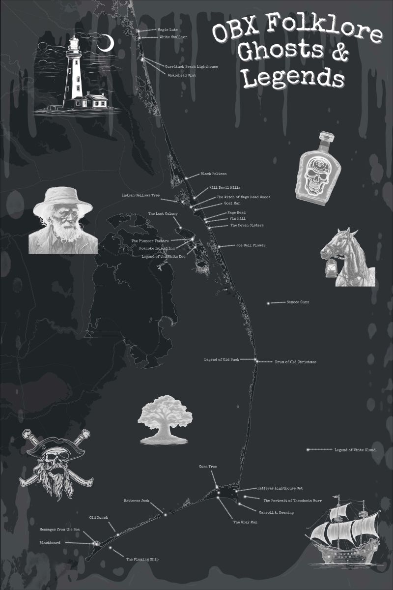
One of North Carolina’s most famous mysteries, the “Lost Colony,” is among the more than 30 tales, tragedies and legends from the barrier islands to get lost in — virtually — while using Dare County’s new interactive map, “OBX Folklore: Your gateway to Outer Banks Legends, Ghosts, and Folklore.”
The map allows users to “delve deeper into the many eerie and mysterious occurrences that have taken place over the years and have ultimately become legends that are passed down from generation to generation,” the county said in an announcement earlier this week.
Supporter Spotlight
Dare County GIS Specialist Kristen Stilson and county librarians Meaghan Leenaarts Beasley and Theresa Cozart spent the last year collaborating on the website that celebrates Geographic Information Systems Day 2024 on Nov. 20.
“The Outer Banks has a long history full of lore to choose from, from Native American tales to modern day frights. This made for a really diverse set of stories to educate and entertain both the readers and us,” Stilson said in the announcement.
Stilson explained to Coastal Review Tuesday that the county had been creating special maps to celebrate GIS Day since 2019. Past projects include the 2019 Look Back Map, the 2020 Shipwreck Map, the 2021 Trivia Map, the 2022 OBX Days Gone By Map, and the 2023 Pop Culture Map, all available on the Dare County website.
The idea for this year’s map on Outer Banks folklore came about through a conversation they had about a year ago.
Cozart said that when she was hired last November, she and Stilson began talking about the 2023 Pop Culture Map, which had just been released for GIS Day, and of the interesting places in Dare County.
Supporter Spotlight
“Kristen was telling me about all the fun maps she had created and how I should check them out to help me get a feel for the Outer Banks. Kristen’s excitement about these maps was infectious,” Cozart explained.
Coming from Wilmington, Cozart continued, “I started talking about all the ‘haunted’ locations down there and fun ghost tours. Kristen and Meaghan then started telling me about folklore associated with the Outer Banks and I said that sounded like a fun map that everyone would enjoy.”
Stilson said that since she tries to make a fun map for each GIS Day, she drew inspiration from Cozart’s idea and they decided to collaborate on the folklore map.
“It took us a few months to make, with all of us working on it in our spare time and adding a few things here and there,” Stilson said.
The map is best viewed on a desktop for all the effects but will work on all devices. “You can read the stories in any order you like thanks to the dropdown menu but I ordered the stories from North to South,” Stilson added.
The earliest stories date back to the “Lost Colony of Roanoke” and the “Legend of the White Doe,” both late 1500s, Beasley told Coastal Review.
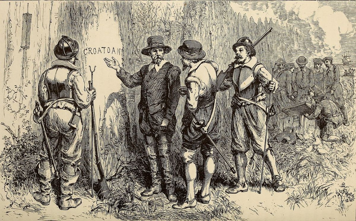
The story of the “Lost Colony” begins in the summer of 1587, when men, women and children attempt to establish Roanoke Colony, the first permanent English outpost in North America. About 115 English settlers arrived at Roanoke Island, welcoming a month later Virginia Dare, the first English child born in the New World. Later that year, Roanoke Colony’s governor, John White, returned to England for supplies, leaving the colonists behind.
White’s return to North America was delayed by three years because of war with Spain. When he made his way back in 1590, he found the colonists had disappeared and the only clues were “CRO” and “CROATOAN” carved on trees. “Though there are many theories about their fate, the colonists were never found and what happened to them remains a mystery to this day.”
One version of the “Legend of the White Doe” suggests that Virginia Dare was raised among the Croatoan. As she matured, she became a great beauty, drawing the unwanted attention of a young chieftain who, angry at her rejection, tricks her into drinking a potion that turns her into a white doe.
Stilson said in the press release that they chose stories for the map based on ones “we knew growing up or ones that we hadn’t heard that spoke to us.”
Stilson explained in a follow-up interview Tuesday that one of the legends from her youth is about the “goat man,” the most recent tale featured on the map.
The goat man legend began circulating in the 1970s, gaining momentum in the decades that followed. The story goes that a man lived in a yellow shack in Nags Head Woods with just his goats to keep him company. One night, teens vandalized his house while he was away, killing all of his goats. It is rumored that he kidnaps or chases teenagers, the map states.
Stilson continued that when she was growing up, she had always heard the story of the goat man. “Friends and I looked for him in Nags Head Woods.”
One legend Stilson had not heard before is the story of the magic lute, she said, “but for some reason I was really drawn to that one and wanted to write it up.”
The magic lute is a tale from the 1600s about two sisters in Currituck vying for the same man’s affection, and the musician who used strands of the chosen sister’s hair, who was drowned by the rejected sister, to replace the broken strings of his lute.
Cozart moved to Dare County in November 2023 from Wilmington. She said in an interview that she “really enjoyed learning about the local legends” since she’s new to the Outer Banks and “I love a good ghost story.”
She said she is partial to their very own poltergeist in the Kill Devil Hills Library. The branch where she is based opened 34 years ago.
“I usually get here first thing in the morning and I’ve heard stuff. Usually it’s in the back areas — meeting room and kitchen. I’ve raced back there to see what was making noise and there was nothing there. It’s happened several times,” Cozart said. “Others here say they’ve had books found on the floor that were on the shelves when we closed up the night before. I haven’t experienced that yet, but I’m keeping on the poltergeist’s good side.”
Cozart said her favorite story that she came across is about the Whalehead Club. Built in 1922, the 21,000-square-foot house in Corolla was a winter home until 1933 when the original owners made their last visit. The couple died in 1936. Uneasy feelings are reported at the building and it has been investigated by paranormal researchers.
“So creepy that the original owners just abandoned that huge house,” Cozart added.
For Beasley, the Queen of the Sounds is “a perfect Halloween tale with witches, explosions and ghosts.”
The Queen of the Sounds was a riverboat commissioned after the Civil War that toured through the Currituck and Albemarle sounds. The owner supposedly fell in love with a witch, and their relationship ended when the riverboat exploded on a Sunday, after a ceremony to summon the devil.

Beasley said in a press release that it was a “natural fit” for library staff to work with Stilson on the interactive map.
“Not only do we have physical collections of celebrated folklorists, most notably Charles Harry Whedbee, but we also have little-known Outer Banks authors and locally written pamphlets of eerie tales and legends that often go overlooked,” Beasley continued. “While some of these items reside in our reference collections due to their age or rarity and can only be viewed in our libraries, many are available for checkout by the public.”
Beasley told Coastal Review that they used about 20 resources, including books and digitized newspapers from the Dare County Library holdings, as well as outside sources such as a photo from the archives of the Outer Banks History Center to build the map.
“It was a pleasant surprise to find a diversity of sources for these legends in our collections – we’re not a large place geographically but we’ve had some legendary events here,” Beasley said.
In each of the county’s three branches, the resources are on display along with a 24-inch by 36-inch framed poster of the OBX Folklore Map. Patrons can enter the raffle at the branches located in Hatteras, Kill Devil Hills and Manteo between Thursday and Nov. 19. A winner will be selected from each branch Nov. 20, on GIS day.


