The panel of scientists that advises the North Carolina Coastal Resources Commission will continue its review of inlet hazard areas boundaries during a web conference on Wednesday.
The 2 p.m. meeting will be the latest round of efforts by the CRC Science Panel to update decades-old inlet hazard area, or IHA, maps.
Supporter Spotlight
IHAs are shorelines especially vulnerable to erosion and flooding where inlets can shift suddenly and dramatically. Erosion rates are more similar and evenly parallel along a straight shoreline. That’s not the case at inlet shores, which curve around.
After initially forming in the late 1990s, the Science Panel identified a need to update the state’s IHAs. Since then, the Science Panel has discussed how to best predict inlet erosion and accretion rates at IHAs and recommended updated boundaries.
Updates were proposed in 2010, but discussions on those were sidelined by a state-implemented terminal groin study and a study of oceanfront erosion rates.
The CRC in 2015 unanimously approved rule amendments and redrawn boundaries for IHAs, but Division of Coastal Management officials later withdrew those citing the need for additional review on rules pertaining to size and location of buildings allowed within inlet areas.
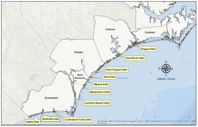
Ten of North Carolina’s 19 active inlets are developed, including Tubbs, Shallotte and Lockwood Folly in Brunswick County; Carolina Beach, Masonboro, Mason and Rich in New Hanover County; New Topsail and New River in Pender County; and Bogue Inlet in Carteret County.
Supporter Spotlight
The public may listen to the meeting by computer or phone.
Join webinar # 2422 033 0197 via Webex | Password: science2024 (72436232 from phones)
Join by phone: 1-415-655-0003 | Access code: 2422 033 0197
A listening station will be established at DCM headquarters at 400 Commerce Ave. in Morehead City.
Interested parties may submit comments by email to DCMcomments@deq.nc.gov. List “Science Panel” in the subject line.
The division carries out the state’s Coastal Area Management Act, the Dredge and Fill Law and the federal Coastal Zone Management Act of 1972 in the 20 coastal counties, using rules and policies enacted by the Coastal Resources Commission. The division also serves as staff to the commission.


